A chart of the South Sea / by J. Seller, J. Colson, W. Fisher, J. Atkinson & J. Thornton ; Dundee, sculp
A chart of the South Sea / by John Seller, Hydrographer to the Kings most Excellent Majestie ; Dundee, sculp

A Chart of the SOUTH=SEA
A chart of ye eastermost part of the East Indies / by Iohn Seller

A chart of the eastermost part of the East Indies with all the adjacent islands from Cape Comorin to Iapan / by Iohn Seller, Hydrographer to the King ; F. Lamb Sculp

A Generall Chart of the South Sea from the River of Plate to Dampiers Streights on ye Coast of New...

Chart of the S.W. Part of Japan from a dutch MS / by A. Dalrymple ; W. Harrison sc

Chart of the S.W. Part of Japan from a dutch MS / by A. Dalrymple ; W. Harrison sc
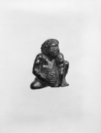
Netsuke in the Form of a Korumbo (South Sea Islander)
A chart of the eastermost part of the East Indies with all the adjacent islands from Cape Comorin to Iapan / by Iohn Seller, Hydrographer to the King
A Chart of the Northern Part of the China Sea [Material cartográfico] : shewing the Passage from F...
Portion of NZ transport south east of Mersa Matruh, Egypt - Photograph taken by W A Whitlock

The Game of Go; A Shoemakers; Entertainment; A Flower Seller
A New & Correct Chart of the Indian Sea From Cabo Bonea Esperanca to Japan [Material cartográfico]...

A chart of the Tartarian Sea from Nova Zemla to Japan

A Buoy on the Sea of Time - J (Toki no fuhyō - J) (時の浮標)
![Russian Empire [with] Chart of the Communication Between The Archipelago And Black Sea](https://stacks.stanford.edu/image/iiif/bk956jy9388%2F18960/full/!200,200/0/default.jpg)
Russian Empire [with] Chart of the Communication Between The Archipelago And Black Sea
L J Fisher and A R Cross in a well loaded jeep on the Italian Front, World War II - Photograph taken by Geor...
Maritime territorial disputes in East Asia: a comparative analysis of the South China Sea and the ...

The Geisha Emu of Matsuya as a Cormorant Fisher

Benten on a rock by the sea
A new & correct chart of the Indian Sea from Cabo Bonea Esperanca to Japan according to Mr. Edward Wrights projection vulgarly called Mercators chart
A chart of the northern part of the China Sea shewing the passage from Formosa to Japan : with the eastern coast of China and the Lekeyo Islands

A New & Accurate Chart of the Discoveries made by the late Capt. Js. Cook, and other distinguished...
Japan : Nipon, Kiusiu and Sikok, and a part of the coast of Korea / according to Krusenstern's Chart of 1827 ; J & C Walker sculpt
Nieuwe wassende graet kaert van Oost Indien van d. C. d Bono Esperanca tot t'Lant Eso / gedruckt by I. Robyn met Privilege
A Chart of the SOUTH=SEA
Pascaerte vande Zuyd-Zee tussche California, en Ilhas de Ladrones / by Pieter Goos, op't Waater inde Vergulde Zeespiegel
Nanʼyō Shotō oyobi Santō Hantō Kuroiwa Yoshima cho
The entrance of Nangasacqui the chief port of the island of Kiusiu in the Kingdom of Japan from the manuscript chart of the Dutch East India Company
A chart of the northern part of the China Sea shewing the passage from Formosa to Japan with the eastern coast of China and the Lekeyo islands / by Van Kuelen ; improved from the maps drawn in China by Father Gaubil in 1752

Mare Del Sud Detto Altrimente Mare Pacifico

「米国公使館通事ヒウスケン遭難関係地図及顛末」
![[下図]「石川郡分間絵図」文政五年](https://adeac.jp/items/imizu-shinminato-mus/catalog/mp105870-15100/3-1-C85v2.jpg)
[下図]「石川郡分間絵図」文政五年
Map of the missionary districts of north Tokyo & Kyoto : under the jurisdiction of the Bishop of Tokyo 1895

New map of Shanghai. (on verso) A map of China : Published by K. Saito. Osaka Japan Sole agent T. ...
ふみ(文)のはやし

「」

「凌雲院様御供開場絵図」

「」
![[Palembang and Bangka Island, Indonesia] Het Eiland Banka. 1819 [and] De Rivier van Palembang. 1821](https://stacks.stanford.edu/image/iiif/vz793zp5933%2F36200/full/!200,200/0/default.jpg)
[Palembang and Bangka Island, Indonesia] Het Eiland Banka. 1819 [and] De Rivier van Palembang. 1821

Carte réduite de l'océan septentrional compris entre l'Asie et l'Amérique ... Par le Sr. Bellin ..
![Pascaerte vande Zuyd-Zee tussche California, en Ilhas de Ladrones [cartographic material] / by Pieter Goos, ...](https://collections.library.yale.edu/iiif/2/15825821/full/!200,200/0/default.jpg)
Pascaerte vande Zuyd-Zee tussche California, en Ilhas de Ladrones [cartographic material] / by Pieter Goos, ...

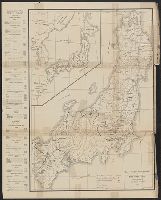
Japan, acreage of rice by prefectures, 1939. Japan, acreage of wheat by prefectures, 1939
![[Carte simplifiée de l'Ouest de la ville d'Osaka.]](https://api.europeana.eu/api/v2/thumbnail-by-url.json?uri=http%3A%2F%2Fgallica.bnf.fr%2Fark%3A%2F12148%2Fbtv1b530667820.thumbnail.jpg&type=IMAGE)
[Carte simplifiée de l'Ouest de la ville d'Osaka.]
Dai Nihon yochi zenzu / Kodama Matashichi

Nouvelle Carte de la Partie Septentrionale du Globe, comprise entre le Kamtchatka et la Californie...

「看々天狗」

「正月三日御拵絵図」
最終更新日: 2020-06-05
登録日: 2021-07-22