![Pascaerte vande Zuyd-Zee tussche California, en Ilhas de Ladrones [cartographic material] / by Pieter Goos, ...](https://collections.library.yale.edu/iiif/2/15825821/full/!200,200/0/default.jpg)
Pascaerte vande Zuyd-Zee tussche California, en Ilhas de Ladrones [cartographic material] / by Pieter Goos, ...
- People
- Time
- Owner Organization
Pascaerte vande Zuyd-Zee tussche California, en Ilhas de Ladrones / by Pieter Goos, op't Waater inde Vergulde Zeespiegel
National Library of Australia
Trove: National Library of Australia
Pascaerte vande Zuyd-Zee tussche California, en Ilhas de Ladrones / by Pieter Goos, op't Waater inde Vergulde Zeespiegel
State Library of New South Wales
Trove: National Library of Australia

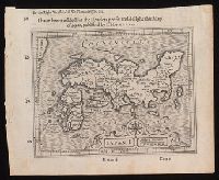
Pascaerte vande Zuyd-Zee tusche California, en Ilhas de Ladrones . . . 1666 (shows New Zealand, Ca...
Stanford University Libraries
Stanford Libraries SearchWorks

Pas-caart van Zuyd-Zee, tusschen California en ilhas de Ladrones
Stanford University Libraries
Stanford Libraries SearchWorks

Pas-Caart van Zuyd-Zee tusschen California en Ilhas de Ladrones . . . (shows New Zealand, Carpenta...
Stanford University Libraries
Stanford Libraries SearchWorks

Magnum Mare del Zur cum Insula California | De Groote Zuyd-Zee en 't Eylandt California
Stanford University Libraries
Stanford Libraries SearchWorks

Magnum Mare del Zur cum Insula California | De Groote Zuyd-Zee en 't Eylandt California
Stanford University Libraries
Stanford Libraries SearchWorks

Magnum Mare del Zur cum Insula California | De Groote Zuyd-Zee en 't Eylandt California
Stanford University Libraries
Stanford Libraries SearchWorks
![Map of Manchuria, Corea & Japan [cartographic material]](https://collections.library.yale.edu/iiif/2/15828540/full/!200,200/0/default.jpg)
Map of Manchuria, Corea & Japan [cartographic material]
Yale University Library
Yale University Library Digital Collections

Eastern Asia
Yale University Library
Yale University Library Digital Collections
![(A Set of Landform and Outline Maps by Erwin Raisz) [cartographic material].](https://stacks.stanford.edu/image/iiif/vf022zq3993%2F7943001/full/!200,200/0/default.jpg)
(A Set of Landform and Outline Maps by Erwin Raisz) [cartographic material].
Stanford University Libraries
Stanford Libraries SearchWorks
![China and Japan [cartographic material]](https://collections.library.yale.edu/iiif/2/15828553/full/!200,200/0/default.jpg)
China and Japan [cartographic material]
Yale University Library
Yale University Library Digital Collections
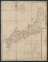
Japan I
Yale University Library
Yale University Library Digital Collections
![Accuratissima totius Asiae tabula [cartographic material] : in omnes partes divisa, de nova correcta, ac in ...](https://collections.library.yale.edu/iiif/2/16669381/full/!200,200/0/default.jpg)
Accuratissima totius Asiae tabula [cartographic material] : in omnes partes divisa, de nova correcta, ac in ...
Yale University Library
Yale University Library Digital Collections
![Japan, radiotelephone and radiotelegraph stations [cartographic material] : 1941](https://stacks.stanford.edu/image/iiif/pp234mp0165%2Fpp234mp0165_00_0001/full/!200,200/0/default.jpg)
Japan, radiotelephone and radiotelegraph stations [cartographic material] : 1941
Stanford University Libraries
Stanford Libraries SearchWorks
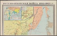
Русско-японская война 1904-1905 гг. / карта составлена Научно-редакционной картосоставительской частью ГУГК ...
Yale University Library
Yale University Library Digital Collections

Nemuro
Yale University Library
Yale University Library Digital Collections
![Exactissima Asiae delineatio, in praecipuas regiones, ceterasq [cartographic material] : partes divisa, et d...](https://collections.library.yale.edu/iiif/2/16618498/full/!200,200/0/default.jpg)
Exactissima Asiae delineatio, in praecipuas regiones, ceterasq [cartographic material] : partes divisa, et d...
Yale University Library
Yale University Library Digital Collections
![Bering Sea, Japanese fishing and associated activities, 1930-1941 [cartographic material]](https://stacks.stanford.edu/image/iiif/kb473nj6517%2Fkb473nj6517_00_0001/full/!200,200/0/default.jpg)
Bering Sea, Japanese fishing and associated activities, 1930-1941 [cartographic material]
Stanford University Libraries
Stanford Libraries SearchWorks
![Far East, Japanese occupied area, major railroads [cartographic material] / Board of Economic Warfare, Enemy...](https://collections.library.yale.edu/iiif/2/15510697/full/!200,200/0/default.jpg)
Far East, Japanese occupied area, major railroads [cartographic material] / Board of Economic Warfare, Enemy...
Yale University Library
Yale University Library Digital Collections
![China and Japan [cartographic material] / compiled from G.S.G.S. 4065 and 2957](https://collections.library.yale.edu/iiif/2/15510764/full/!200,200/0/default.jpg)
China and Japan [cartographic material] / compiled from G.S.G.S. 4065 and 2957
Yale University Library
Yale University Library Digital Collections
Japan-China War, 1894-5
Yale University Library
Yale University Library Digital Collections
![Japan and adjacent regions of Asia and the Pacific Ocean [cartographic material] / compiled and drawn in the...](https://collections.library.yale.edu/iiif/2/15510875/full/!200,200/0/default.jpg)
Japan and adjacent regions of Asia and the Pacific Ocean [cartographic material] / compiled and drawn in the...
Yale University Library
Yale University Library Digital Collections
![Japan and adjacent regions of Asia and the Pacific Ocean [cartographic material] / compiled and drawn in the...](https://collections.library.yale.edu/iiif/2/15509964/full/!200,200/0/default.jpg)
Japan and adjacent regions of Asia and the Pacific Ocean [cartographic material] / compiled and drawn in the...
Yale University Library
Yale University Library Digital Collections

A Chart of the SOUTH=SEA
Stanford University Libraries
Stanford Libraries SearchWorks
Pascaerte vande Zuyd-Zee tusche California, en Ilhas de Ladrones . . . 1666 (shows New Zealand, Ca...
Stanford University Libraries
Stanford Libraries SearchWorks

A Generall Chart of the South Sea from the River of Plate to Dampiers Streights on ye Coast of New...
Stanford University Libraries
Stanford Libraries SearchWorks
Pas-caart van Zuyd-Zee, tusschen California en ilhas de Ladrones
Stanford University Libraries
Stanford Libraries SearchWorks

Carte Reduite De L'Ocean Septentrional compris entre l'Asie et l'Amerique Suivant les Decouvertes ...
Stanford University Libraries
Stanford Libraries SearchWorks

Carte réduite de l'océan septentrional compris entre l'Asie et l'Amérique ... Par le Sr. Bellin ..
Yale University Library
Yale University Library Digital Collections

Mar Del Zur Hispanis Mare Pacificum (Rare 2nd State with Tasman's Discoveries)
Stanford University Libraries
Stanford Libraries SearchWorks

Carte Reduite De L'Ocean Septentrional compris entre l'Asie et l'Amerique Suivant les Decouvertes ...
Stanford University Libraries
Stanford Libraries SearchWorks

Carte des découvertes au Nord du Japon faites en 1643 par les vaisseaux hollandais le Kastrikum et...
Bibliothèque nationale de France
Europeana API

Tabula Indiae Orientalis et Regnorum Adjacentium J. Van Braam et G. onder de Linden . .
Stanford University Libraries
Stanford Libraries SearchWorks

Carte Reduite De L'Ocean Septentrional compris entre l'Asie et l'Amerique Suivant les Decouvertes ...
Stanford University Libraries
Stanford Libraries SearchWorks

Iles Kouriles, Yeso et Sakhaline
Bibliothèque nationale de France
Europeana API

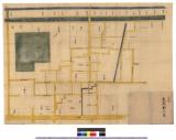
改 高家御役屋敷手扣絵図
Kyoto University Library
IIIF Discovery in Japan
日置村図 : 名古屋図
Iwase Bunko Libray
ADEAC: A System of Digitalization and Exhibition for Archive Collections

drawing
British Museum
British Museum Collection

Carte des Costes de L'Asie Sur L'Ocean Contenant les Bancs Isle et Costes &c. (Indian Ocean, South...
Stanford University Libraries
Stanford Libraries SearchWorks
![Hailaerh fukin zu [cartographic material]](https://stacks.stanford.edu/image/iiif/nc103dh1915%2Fnc103dh1915_00_0001/full/!200,200/0/default.jpg)
Hailaerh fukin zu [cartographic material]
Stanford University Libraries
Stanford Libraries SearchWorks

Carte réduite de l'Ocean Oriental depuis le Cap de Bonne Espérance jusqu'au Japon / dressée sur le...
Bibliothèque nationale de France
Europeana API

Japan distribution of waterworks
Stanford University Libraries
Stanford Libraries SearchWorks

高家御役屋敷絵図
Kyoto University Library
IIIF Discovery in Japan
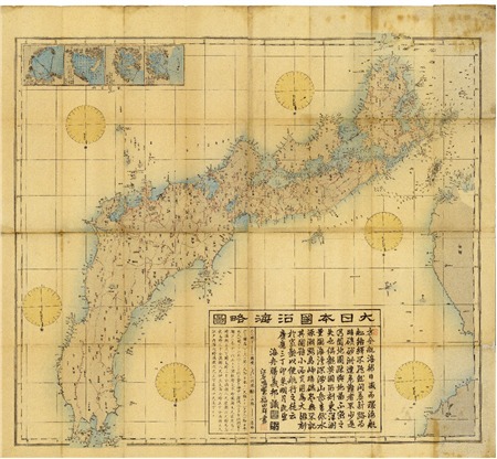
Dainihonenkairyakuzu
Geospatial Information Authority of Japan
FishPix
Carte de L'Empire du Japon ..
Yale University Library
Yale University Library Digital Collections
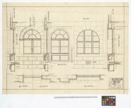
遠州銀行本店(本館側窓詳細図)
Hamamatsu City Central Library
ADEAC: A System of Digitalization and Exhibition for Archive Collections

Asie entre l'Angara, le Kamtchatka, Macao et le Pacifique, y compris Formose et le Japon / par le ...
Bibliothèque nationale de France
Europeana API
Last Updated: 2021-01-30
Uploaded: 2021-07-29