
Japan, acreage of rice by prefectures, 1939. Japan, acreage of wheat by prefectures, 1939
- Time
- Owner Organization
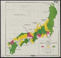
Japan : industrial concentration by prefectures
![Japan [cartographic material] : industrial concentration by prefectures](https://stacks.stanford.edu/image/iiif/zh931gv1396%2Fzh931gv1396_00_0001/full/!200,200/0/default.jpg)
Japan [cartographic material] : industrial concentration by prefectures

Japan : population densities by prefectures and provinces
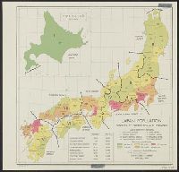
Japan: population densities by prefectures and province

Population densities in Japan : Densities by prefectures and provinces
The wheat among the tares studies of Buddhism in Japan
The Emperor of Japan in his Coronation robes. (Evening Post, 23 January 1939)
[Dosa med lock, stengods. Japan ca. 1939- 40]
First Polish Trade Agreement with Japan since 1939

Connecting traditions. The Spirit of the Rice Field (Japan)
Example of accent from Fukushima, Japan, by female born 1974
Example of accent from Hokkaido, Japan, by male born 1988
Migrant arrivals and departures to New Zealand by citizens of Japan - By direction of travel, 2001–2019, num...
Interior of a Japanese house (Evening Post, 27 May 1939)
Example of accent from Japan, by female born 1988

Catalogue of vertebrated animals of Japan / by S. Okada
Catalogue of vertebrated animals of Japan / by S. Okada
Sports stadium used by New Zealanders of J Force, Yamaguchi, Japan
Tectonic map of Japan / compiled by Hiroshi Isomi in 1965

Japan, wheat, showing the relative amount of production in colors, from light, lowest, to dark, highest
Example of accent from Osaka, Japan, by male born 1991

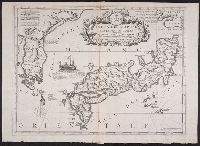
A map of the Empire of Japan, made by Dr. Kaempfer [with maps of Kamchatka, Northern coast of Japan, as well...
Political relations and conflict between republican China and imperial Japan, 1930-1939 [electroni...
Example of accent from Asahikawa, Japan, by female born 1972

Carte des Isles du Japon et la Presqu Isle de Coree Avec les Costes de la Chine. Depuis Pekin Jusqu'a Canton...

Jūmanbunnoichi Guamutō fukin

Manshū Gomanbun no ichi Haisen Kokusan fukin

Durville Island and Approaches

Plans on the north-eastern coast of New Guinea

Plans of Anchorages in Witu Islands

Skizze des weges von Tokio nach Yumotto (Nikko Berge) nach eigenen Aufzeichnungen / von E. Knippin...

Descripcion De Las Indias Del Poniente
Chart of Japanese islands and surrounding seas

Ryōtō Kaiwan : Daitzu Shan to Fuchou Chao
The island of Formosa

China - east coast : Hangchow Wan - southeast portion : including the approaches to the Yung Kiang

Descripcion De Las Yndias Ocidentales
![America Bay [cartographic material]](https://stacks.stanford.edu/image/iiif/nj035cf2832%2Fnj035cf2832_00_0001/full/!200,200/0/default.jpg)
America Bay [cartographic material]

Central Portion of Sumbawa with Pulo Tenga Islands

Partie Septentrionale De L'Ocean Pacifique ou L'on Marque Les Decouvertes Et Les Routes De Mrs. De...
![[Spanish Chart of the Philippines, China, Japan, Korea, Kamtchatka, Western Pacific]](https://stacks.stanford.edu/image/iiif/nk348cb2252%2F42187sh/full/!200,200/0/default.jpg)
[Spanish Chart of the Philippines, China, Japan, Korea, Kamtchatka, Western Pacific]

Plans in south eastern part of New Guinea
![[Japan] (Published in Manila!)](https://stacks.stanford.edu/image/iiif/gv355sq3352%2F37869hs/full/!200,200/0/default.jpg)
[Japan] (Published in Manila!)
森林鉄道布設図
Isola del Giapone e penisola de Corea / Vincenzo Coronelli

Chart Prepared By James B. Moore, To Accompany His Memorial To Congress Respecting the subject of ...

North West Pacific Ocean : Including Yellow, Japan & Okhotsk Seas, the Kuril Islands and Kamchatka
Japanese mandated islands / prepared by Naval Intelligence Division
Last Updated: 2020-04-17
Uploaded: 2021-09-21