
A New & Accurate Chart of the Discoveries made by the late Capt. Js. Cook, and other distinguished...
- People
- Time
- Owner Organization

An Accurate Chart of the World, with the New Discoveries; Also a View of the General & Coasting Tr...
Stanford University Libraries
Stanford Libraries SearchWorks
Asia with its islands and different regions : according to their modern divisions ; also the discoveries made by Capt. Cook
National Library of Australia
Trove: National Library of Australia

Chart of the Discoveries made in 1787, in the Seas of China and Tartary by the Boussole and Astrol...
Stanford University Libraries
Stanford Libraries SearchWorks

Chart of Discoveries made in 1787, in the Seas of China and Tartary, by the Boussole and Astrolabe...
Stanford University Libraries
Stanford Libraries SearchWorks

A New and Accurate Map of the Colony of Massachusets Bay, In North America from a Late Survey
Stanford University Libraries
Stanford Libraries SearchWorks

A New and Accurate Map of the Colony of Massachusets Bay, In North America from a Late Survey
Stanford University Libraries
Stanford Libraries SearchWorks

Chart of Discoveries made in 1787 In the Seas of China and Tartary between Manilla and Avateha by ...
Stanford University Libraries
Stanford Libraries SearchWorks

A new and accurate map of the Empire of Japan. Laid down from the memoirs of the Portuguese and Du...
Stanford University Libraries
Stanford Libraries SearchWorks
Asia and its islands according to Danville : divided into empires, kingdoms, states, regions &ca. with the European possessions and settlements in the East Indies and an exact delineation of all the discoveries made in the Eastern parts by the English under Captn. Cook
State Library of New South Wales
Trove: National Library of Australia

A New and Accurate Map of the Empire of Japan Laid down from the Memoirs of the Portugese and Dutc...
Stanford University Libraries
Stanford Libraries SearchWorks

A New and Accurate Map of the World. Drawn from the best Surveys and regulated by Astronomical Obs...
Stanford University Libraries
Stanford Libraries SearchWorks

A new and accurate map of the Empire of Japan : laid down from the memoirs of the Portuguese and Dutch, and ...
Yale University Library
Yale University Library Digital Collections

A New and Correct Chart of all the Known World Laid down according to Mercator's Projection
Stanford University Libraries
Stanford Libraries SearchWorks

A New and Correct Chart of all the Known World Laid down according to Mercator's Projection
Stanford University Libraries
Stanford Libraries SearchWorks

A New and Correct Chart of all the Known World Laid down according to Mercator's Projection
Stanford University Libraries
Stanford Libraries SearchWorks
A new & accurate map of Asia : drawn from the most approved modern maps & charts / by Thos. Bowen ; engraved for Middletons complete system of geography
National Library of Australia
Trove: National Library of Australia
Laurie and Whittle's new chart of the Indian and Pacific Oceans between the Cape of Good Hope, New Holland, and Japan, comprehending New Zealand, New Caledonia, New Britain, New Ireland, New Guinea,&c., Louisiade and New Georgia; also the Pelew, New Caroline, Ladrone, and Philippine Islands; &c. with the most remarkable tracks of the English, Spanish, French and Dutch navigators: and chiefly the track of the Walpole, Eastindiaman, Captn. Thos. Butler, 1794 from the Cape of Good Hope to Van Diemen's Land and, from thence to China, and the track of the Royal Admiral Captn. Henr. Bond in 1792 and 93, from the Cape to Port Jackson and China
National Library of Australia
Trove: National Library of Australia
Laurie and Whittle's new chart of the Indian and Pacific Oceans between the Cape of Good Hope, New Holland and Japan : comprehending New Zealand, New Caledonia, New Britain, New Ireland, New Guinea &c., Louisiade and New Georgia; also The Pelew, New Caroline, Ladrone and Philippine Islands &c. with the most remarkable tracks of the English, Spanish, French and Dutch navigators and chiefly the track of the Walpole, EastIndiaman, Captn. Thos. Butler, 1794 from the Cape of Good Hope to Van Diemen's Land and from thence to China, and the track of the Royal Admiral Captn. Henr. Bond in 1792 and 93 from the Cape to Port Jackson and China
State Library of New South Wales
Trove: National Library of Australia

A new chart of the Pacific Ocean : exhibiting the western coast of America, from Cape Horn to Beerings Strait, the eastern shores of Asia including Japan, China and Australia and all the numerous islands and known dangers situated in Polynesia and Australasia / correctly drawn and regulated according to the most approved and modern surveys and astronomical observations by J.W. Norie
State Library of New South Wales
Trove: National Library of Australia
![[Southeast Asia, China & India]](https://stacks.stanford.edu/image/iiif/jj467gk2095%2F0171gh/full/!200,200/0/default.jpg)
[Southeast Asia, China & India]
Stanford University Libraries
Stanford Libraries SearchWorks
Eis van het college
Royal Library of the Netherlands
Europeana API

〔冨士講社諸国商人定宿引札〕
Mt.Fuji World Heritage Center, Shizuoka
ADEAC: A System of Digitalization and Exhibition for Archive Collections
![[Japan] (Published in Manila!)](https://stacks.stanford.edu/image/iiif/gv355sq3352%2F37869hs/full/!200,200/0/default.jpg)
[Japan] (Published in Manila!)
Stanford University Libraries
Stanford Libraries SearchWorks

Carte réduite de l'océan septentrional compris entre l'Asie et l'Amérique ... Par le Sr. Bellin ..
Yale University Library
Yale University Library Digital Collections

Ryōtō Kaiwan : Daitzu Shan to Fuchou Chao
Stanford University Libraries
Stanford Libraries SearchWorks

Descripcion De Las Yndias Ocidentales
Stanford University Libraries
Stanford Libraries SearchWorks
Eis van de gouverneur van Nangasakij
Royal Library of the Netherlands
Europeana API

Asia : Coast of China : Ryōtō Kaiwan. Approaches to Ryō Ga Entrance
Stanford University Libraries
Stanford Libraries SearchWorks

「豊国神社祭礼行粧図」
C. V. Starr East Asian Library, University of California, Berkeley
ARC Ukiyo-e Portal Database

Empire of Japan. (with) Nagasaki Harbour. Engraved by J. & C. Walker. Published under the superint...
Stanford University Libraries
Stanford Libraries SearchWorks
Eis van de opperburgermeester
Royal Library of the Netherlands
Europeana API
![Indo Hyakumanbunnoichi Zu Tōbu Shūiki [cartographic material]](https://stacks.stanford.edu/image/iiif/wr290sd1084%2Fwr290sd1084_00_0001/full/!200,200/0/default.jpg)
Indo Hyakumanbunnoichi Zu Tōbu Shūiki [cartographic material]
Stanford University Libraries
Stanford Libraries SearchWorks

Shiberia jūmanbun no ichizu Urajiosutoku
Stanford University Libraries
Stanford Libraries SearchWorks
Eis van de gouverneur van Nangasakij
Royal Library of the Netherlands
Europeana API
![[Spanish Chart of the Philippines, China, Japan, Korea, Kamtchatka, Western Pacific]](https://stacks.stanford.edu/image/iiif/nk348cb2252%2F42187sh/full/!200,200/0/default.jpg)
[Spanish Chart of the Philippines, China, Japan, Korea, Kamtchatka, Western Pacific]
Stanford University Libraries
Stanford Libraries SearchWorks
Eis van de opperburgermeester
Royal Library of the Netherlands
Europeana API

Carte des Isles du Japon et la Presqu Isle de Coree Avec les Costes de la Chine. Depuis Pekin Jusqu'a Canton...
Yale University Library
Yale University Library Digital Collections

Karte von Australien oder Polynesien, nach den Zeichnungen, Reisebe Schreibungen und Tagebucher de...
Stanford University Libraries
Stanford Libraries SearchWorks

Hyakumanbun no ichi Nanpō kōkūzu
Stanford University Libraries
Stanford Libraries SearchWorks
The island of Formosa
National Library of Australia
Trove: National Library of Australia

Descripcion De Las Indias Del Poniente
Stanford University Libraries
Stanford Libraries SearchWorks

「都四条自大橋洛東勝地遠望之図」
C. V. Starr East Asian Library, University of California, Berkeley
ARC Ukiyo-e Portal Database
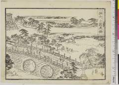
「西大谷円通橋」 「都名勝 三拾景 初編」
Art Research Center, Ritsumeikan University
ARC Ukiyo-e Portal Database
Last Updated: 2020-04-17
Uploaded: 2021-09-21