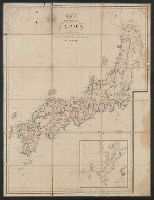
Cook's map of the tourist districts of New South Wales
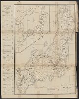
![[Highway map of the Tokyo region].](https://stacks.stanford.edu/image/iiif/gm158cc8245%2Fgm158cc8245_0001/full/!200,200/0/default.jpg)
[Highway map of the Tokyo region].
Map of Tokyo

Amsterdam - Tokyo via the North Pole

Map of Tokyo and Yokohama

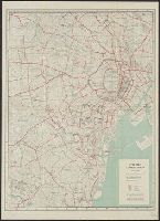
Map of Tokyo : city communications
![Eifuku Tokyo go-ezu [Illustrated map of Tokyo]](https://collections.library.yale.edu/iiif/2/15511725/full/!200,200/0/default.jpg)
Eifuku Tokyo go-ezu [Illustrated map of Tokyo]
City map, central Tokyo. December 1946 / prepared under direction of the chief engineer, general headquarter...
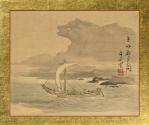
Picture of Kyoto Seascape under the Night Moon
City map, central Tokyo / prepared under the direction of the Engineer, GHQ, FEC ; by the 64th Engineer Base Topographic Battalion

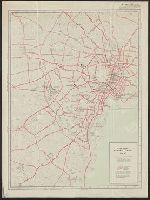
The Guide Map to the Railway in The Neighbourhood of Tokyo
City map, central Tokyo. October 1947 / prepared under direction of the chief engineer, GHQ, FEC, byt the 64...
City map, central Tokyo / prepared under the direction of Office of the Engineer, HQ, AFFE, by the 64th Engineer Battalion (Base Topographic)

Zoning map of town-planning area of Tokyo - 1925
Map showing Green Islands, to the north of Biika. Several of the Japanese bases marked on the map 1 have sin...

Tokyo metropolis. (inset map) Kanto district. (cover title) Tourist map of Tokyo. Japan : where th...
Hiroshima region : A map of the lines under the jurisdiction of to HRDO. Report No. 54k(3)(e), USSBS Index Section 2
Map of area of operation of picket boats under jurisdiction of the 22d Battle Squadron. Report No. 4d, USSBS Index Section 2
East Asia and North Pacific 1:4,350,000 / prepared under the direction of the Chief of Engineers by the Army Map Service (AM) ; U.S. Army, Washington, D.C

Map of Tōkyō : city communications / printed by the Tokyo Printing Co., Ltd
Kowasaki: One of the 53 Tokaido Stations (between Tokyo and Kyoto)
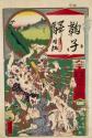
Mariko: One of the 53 Tokaido Stations (between Tokyo and Kyoto)
Bilingual map of Greater Tokyo. Prepared by the Cartographic Division of King Associates. Publishe...
Map of North Africa showing the extent of operations undertaken by the Long Range Desert Group during World ...
Carte de L'Empire du Japon ..
![[下図]「河北郡分間絵図」(文政五年)](https://adeac.jp/items/imizu-shinminato-mus/catalog/mp105720-15100/3-1-C52v2.jpg)
[下図]「河北郡分間絵図」(文政五年)

「鎌倉一覧之図」

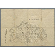
習志野演習場
![[Japan] (Published in Manila!)](https://stacks.stanford.edu/image/iiif/gv355sq3352%2F37869hs/full/!200,200/0/default.jpg)
[Japan] (Published in Manila!)
![[下図]「砺波郡之内五箇山絵図」(文政五年)](https://adeac.jp/items/imizu-shinminato-mus/catalog/mp104440-15100/3-1-BIII42v2.jpg)
[下図]「砺波郡之内五箇山絵図」(文政五年)

百万分一南方航空圖

「西国三十三所順拝地図」
![[下図]「石川郡分間絵図」文政五年](https://adeac.jp/items/imizu-shinminato-mus/catalog/mp105870-15100/3-1-C85v2.jpg)
[下図]「石川郡分間絵図」文政五年
![[清図]「加越能三州郡分略絵図」天保六年一月](https://adeac.jp/items/imizu-shinminato-mus/catalog/mp101160-15100/3-1-A17v2.jpg)
[清図]「加越能三州郡分略絵図」天保六年一月
![Fuji-mi jūsan-shū yochi zenzu [Map of the 13 provinces around Mt. Fuji]](https://collections.library.yale.edu/iiif/2/15510837/full/!200,200/0/default.jpg)
Fuji-mi jūsan-shū yochi zenzu [Map of the 13 provinces around Mt. Fuji]
![[清図]「射水郡分間絵図」文政六年九月](https://adeac.jp/items/imizu-shinminato-mus/catalog/mp101590-15100/3-1-BII19v2.jpg)
[清図]「射水郡分間絵図」文政六年九月

New map of Shanghai. (on verso) A map of China : Published by K. Saito. Osaka Japan Sole agent T. ...
Nieuwe wassende graet kaert van Oost Indien van d. C. d Bono Esperanca tot t'Lant Eso / gedruckt by I. Robyn met Privilege

Tabula Indiae Orientalis et Regnorum Adjacentium J. Van Braam et G. onder de Linden . .

Carte réduite de l'océan septentrional compris entre l'Asie et l'Amérique ... Par le Sr. Bellin ..

Map of Colorado Territory, Compiled from Government Maps & Actual Surveys. Made In 1861

Ryukyu Islands roads, railroads and cables

A Chart of the SOUTH=SEA
富士山頂上図(表口、須山口)
A chart of the South Sea / by J. Seller, J. Colson, W. Fisher, J. Atkinson & J. Thornton ; Dundee, sculp
Illustrated Story about Ono no Komachi (Komachi uta-arasoi), 2nd of 2 Volumes
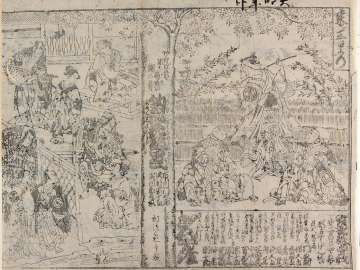
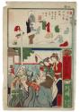
釣狐花設罠、七種粧曽我
![Kaisei dai Nihon bizu [carte du Japon] / par Jikôan Mabuchi](https://api.europeana.eu/api/v2/thumbnail-by-url.json?uri=http%3A%2F%2Fgallica.bnf.fr%2Fark%3A%2F12148%2Fbtv1b53066779q.thumbnail.jpg&type=IMAGE)
Kaisei dai Nihon bizu [carte du Japon] / par Jikôan Mabuchi
最終更新日: 2021-01-30
登録日: 2021-07-29