A new & correct chart of the Indian Sea from Cabo Bonea Esperanca to Japan according to Mr. Edward Wrights projection vulgarly called Mercators chart
- People
- Time
- Owner Organization

A new & correct chart of the Indian sea from Cabo Bonea Esperanca to Japan : according to Mr Edwar...
A New & Correct Chart of the Indian Sea From Cabo Bonea Esperanca to Japan [Material cartográfico]...

A New and Correct Chart of all the Known World Laid down according to Mercator's Projection

A New and Correct Chart of all the Known World Laid down according to Mercator's Projection

A New and Correct Chart of all the Known World Laid down according to Mercator's Projection

A Correct Sea Chart of the Whole World, According to Wright's, Commonly Called Mercator's, Project...

A Correct Sea Chart of the Whole World, According to Wright's, Commonly Called Mercator's, Project...
![[Untitled Sea Chart of Australia, Indian Ocean, China, Japan, SE Asia, &c] (First Printed Map to S...](https://stacks.stanford.edu/image/iiif/cv359wv2441%2F22989/full/!200,200/0/default.jpg)
[Untitled Sea Chart of Australia, Indian Ocean, China, Japan, SE Asia, &c] (First Printed Map to S...

Laurie and Whittle's New Chart of the Indian and Pacific Oceans Between the Cape of Good Hope, New...

Laurie and Whittle's New Chart of the Indian and Pacific Oceans Between the Cape of Good Hope, New...

Zee-atlassen, wereldkaarten enz. >> "A new and correct outline chart intended for the use of...
A New Chart of the Indian and Pacific Oceans Between the Cape of Good Hope, New Holland, and Japan...

A Generall Chart of the South Sea from the River of Plate to Dampiers Streights on ye Coast of New...
Evening Post" Photo. MR. K. SAKAMAKI, a Japanese agriculturist, who is.visiting New Zealand', to study farmi...

A New Chart of The Pacific Ocean, Exhibiting The Western Coast of America from Cape Horn to Beerin...

A New Chart of The Pacific Ocean, Exhibiting The Western Coast of America, From Cape Horn To Beeri...

A New Chart of The Pacific Ocean, Exhibiting The Western Coast of America, From Cape Horn To Beeri...
A New Chart of The Pacific Ocean, Exhibiting The Western Coast of America, From Cape Horn To Beeri...
A new chart of the Indian and Pacific Oceans between the Cape of Good Hope, New Holland and Japan : comprehending New Zealand, New Caledonia, New Britain, New Ireland, New Guinea &c., also the New Caroline, Ladrone and Philippine Islands : with the tracks of the English, French, Spanish and Dutch discoverers
Evening Post" Photo. MR. J. L. THOMAS, ivho returned to New Zealand by the Remuera this morning after teachi...
MR. F. C. CHICHESTER. The New Zealand aviator, who is reported to be making a good recovery from the acciden...

A new chart of the Indian and Pacific Oceans between the Cape of Good Hope, New Holland and Japan : comprehending New Zealand, New Caledonia, New Britain, New Ireland, New Guinea &c., Louisade and New Georgia ; also the Pellew, New Caroline, Ladrone and Philippine Islands; with all these which have been discovered in the year 1788; & the tracks of the English, French, Spanish and Dutch discoverers
Laurie and Whittle's new chart of the Indian and Pacific Oceans between the Cape of Good Hope, New Holland, and Japan, comprehending New Zealand, New Caledonia, New Britain, New Ireland, New Guinea,&c., Louisiade and New Georgia; also the Pelew, New Caroline, Ladrone, and Philippine Islands; &c. with the most remarkable tracks of the English, Spanish, French and Dutch navigators: and chiefly the track of the Walpole, Eastindiaman, Captn. Thos. Butler, 1794 from the Cape of Good Hope to Van Diemen's Land and, from thence to China, and the track of the Royal Admiral Captn. Henr. Bond in 1792 and 93, from the Cape to Port Jackson and China
Laurie and Whittle's new chart of the Indian and Pacific Oceans between the Cape of Good Hope, New Holland and Japan : comprehending New Zealand, New Caledonia, New Britain, New Ireland, New Guinea &c., Louisiade and New Georgia; also The Pelew, New Caroline, Ladrone and Philippine Islands &c. with the most remarkable tracks of the English, Spanish, French and Dutch navigators and chiefly the track of the Walpole, EastIndiaman, Captn. Thos. Butler, 1794 from the Cape of Good Hope to Van Diemen's Land and from thence to China, and the track of the Royal Admiral Captn. Henr. Bond in 1792 and 93 from the Cape to Port Jackson and China

Carte réduite de l'océan septentrional compris entre l'Asie et l'Amérique ... Par le Sr. Bellin ..
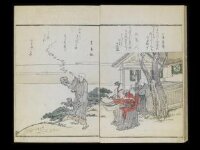
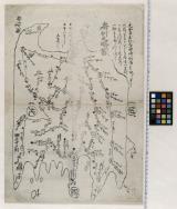
Kuniyoshi's preparatory drawings, no.39
![Hailaerh fukin zu [cartographic material]](https://stacks.stanford.edu/image/iiif/nc103dh1915%2Fnc103dh1915_00_0001/full/!200,200/0/default.jpg)
Hailaerh fukin zu [cartographic material]

A New & Accurate Chart of the Discoveries made by the late Capt. Js. Cook, and other distinguished...
Range upon Range of Mountains
A Correct Sea Chart of the Whole World, According to Wright's, Commonly Called Mercator's, Project...

Japan, acreage of rice by prefectures, 1939. Japan, acreage of wheat by prefectures, 1939
![[Spanish Chart of the Philippines, China, Japan, Korea, Kamtchatka, Western Pacific]](https://stacks.stanford.edu/image/iiif/nk348cb2252%2F42187sh/full/!200,200/0/default.jpg)
[Spanish Chart of the Philippines, China, Japan, Korea, Kamtchatka, Western Pacific]

[Carte de la Tartarie chinoise et des îles du Japon pour servir à la lettre de Mr. d'Anville au Mr...

Japan, political divisions

Carte des Isles du Japon et la Presqu Isle de Coree Avec les Costes de la Chine. Depuis Pekin Jusqu'a Canton...
The island of Formosa
![[Japan] (Published in Manila!)](https://stacks.stanford.edu/image/iiif/gv355sq3352%2F37869hs/full/!200,200/0/default.jpg)
[Japan] (Published in Manila!)
Dai ni-gun no heitan : Meiji sanjūnana-nen hachi-gatsu jūichi nichi
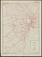
City map, central Tokyo. October 1947 / prepared under direction of the chief engineer, GHQ, FEC, byt the 64...
Kuniyoshi's preparatory drawings, no.39

Carte du Japon sous la féodalité (Les divisions de Mutsu et Dewa datent de 1868). G. Appert / Grav...

実業家所在案内 佐賀市街地図
房州之畧図

滿洲歴史地理. : 第壹巻附図 : 隋代及唐初満洲図(西暦五八九年-六六八年)
Stanford's map of eastern China, Japan and Korea : the seat of war in 1894
Piece
A New and Correct Chart of all the Known World Laid down according to Mercator's Projection

Kita Karafuto niman-gosenbun no ichizu
Last Updated: 2020-06-05
Uploaded: 2021-07-22