
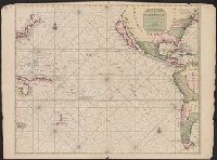
A Generall Chart of the South Sea from the River of Plate to Dampiers Streights on ye Coast of New...
- People
- Time
- Owner Organization

A Chart of the SOUTH=SEA
Stanford University Libraries
Stanford Libraries SearchWorks

A New Chart of The Pacific Ocean, Exhibiting The Western Coast of America from Cape Horn to Beerin...
Stanford University Libraries
Stanford Libraries SearchWorks

A New Chart of The Pacific Ocean, Exhibiting The Western Coast of America, From Cape Horn To Beeri...
Stanford University Libraries
Stanford Libraries SearchWorks

A New Chart of The Pacific Ocean, Exhibiting The Western Coast of America, From Cape Horn To Beeri...
Stanford University Libraries
Stanford Libraries SearchWorks
A New Chart of The Pacific Ocean, Exhibiting The Western Coast of America, From Cape Horn To Beeri...
Stanford University Libraries
Stanford Libraries SearchWorks

Chart of the Coast of China from Cambodia to Nanquam with Part of Japan
Stanford University Libraries
Stanford Libraries SearchWorks

New Guinea - South-East Coast. Approaches to Dedele
Stanford University Libraries
Stanford Libraries SearchWorks
South Pacific - Fiji - Rifle drill for New Zealand soldiers on the coast of Viti Levu
Alexander Turnbull Library
DigitalNZ New Zealand API

(Composite of) A New Chart of The Pacific Ocean, Exhibiting The Western Coast of America, From Cap...
Stanford University Libraries
Stanford Libraries SearchWorks

New Guinea - South Coast. Freshwater Bay to C. Blackwood
Stanford University Libraries
Stanford Libraries SearchWorks
Kaifūzu : Nihon kinkai = Wind chart of Japan coast
National Library of Australia
Trove: National Library of Australia

Oshima, south coast of Japan
Royal Museums Greenwich
Europeana API

Plans on the north-eastern coast of New Guinea
Stanford University Libraries
Stanford Libraries SearchWorks
"Sea-coast of Kanagawa"
Royal Library of the Netherlands
Europeana API

A Chart of the Coast of China From Cambodia to Nanquam with Part of Japan
Stanford University Libraries
Stanford Libraries SearchWorks
A chart of the South Sea / by John Seller, Hydrographer to the Kings most Excellent Majestie ; Dundee, sculp
National Library of Australia
Trove: National Library of Australia
A chart of the northern part of the China Sea shewing the passage from Formosa to Japan : with the eastern coast of China and the Lekeyo Islands
National Library of Australia
Trove: National Library of Australia
A New & Correct Chart of the Indian Sea From Cabo Bonea Esperanca to Japan [Material cartográfico]...
Biblioteca Nacional de España
Europeana API
A new & correct chart of the Indian Sea from Cabo Bonea Esperanca to Japan according to Mr. Edward Wrights projection vulgarly called Mercators chart
National Library of Australia
Trove: National Library of Australia

Chart of the coast of China and of the Japan islands including the Marianes and part of the Philippines
Boston Public Library
DPLA API
Screen with sea eagle along the coast
Rijksmuseum
Europeana API
Screen with sea eagle along the coast
Rijksmuseum
Europeana API
A chart of ye eastermost part of the East Indies / by Iohn Seller
National Library of Australia
Trove: National Library of Australia

A chart of the Tartarian Sea from Nova Zemla to Japan
Royal Museums Greenwich
Europeana API

Pas-caart van Zuyd-Zee, tusschen California en ilhas de Ladrones
Stanford University Libraries
Stanford Libraries SearchWorks

(Southeast Asia, China &c.)
Stanford University Libraries
Stanford Libraries SearchWorks
Mer de Sud ou Pacifique ..
Yale University Library
Yale University Library Digital Collections

Mar Del Zur Hispanis Mare Pacificum (Rare 2nd State with Tasman's Discoveries)
Stanford University Libraries
Stanford Libraries SearchWorks

Carte des Costes de L'Asie Sur L'Ocean Contenant les Bancs Isle et Costes &c. (Indian Ocean, South...
Stanford University Libraries
Stanford Libraries SearchWorks

(Southeast Asia, China &c.)
Stanford University Libraries
Stanford Libraries SearchWorks
![Pascaerte vande Zuyd-Zee tussche California, en Ilhas de Ladrones [cartographic material] / by Pieter Goos, ...](https://collections.library.yale.edu/iiif/2/15825821/full/!200,200/0/default.jpg)
Pascaerte vande Zuyd-Zee tussche California, en Ilhas de Ladrones [cartographic material] / by Pieter Goos, ...
Yale University Library
Yale University Library Digital Collections

(Southeast Asia, China &c.)
Stanford University Libraries
Stanford Libraries SearchWorks

Magnum Mare del Zur cum Insula California | De Groote Zuyd-Zee en 't Eylandt California
Stanford University Libraries
Stanford Libraries SearchWorks

Carte Reduite De L'Ocean Septentrional compris entre l'Asie et l'Amerique Suivant les Decouvertes ...
Stanford University Libraries
Stanford Libraries SearchWorks

Tabula Indiae Orientalis et Regnorum Adjacentium J. Van Braam et G. onder de Linden . .
Stanford University Libraries
Stanford Libraries SearchWorks

Carte Reduite De L'Ocean Septentrional compris entre l'Asie et l'Amerique Suivant les Decouvertes ...
Stanford University Libraries
Stanford Libraries SearchWorks

Pascaart vertoonende de zeecusten van Chili, Peru, Hispania Nova, Nova Granada, en California . .
Stanford University Libraries
Stanford Libraries SearchWorks

Pas-Caart van Zuyd-Zee tusschen California en Ilhas de Ladrones . . . (shows New Zealand, Carpenta...
Stanford University Libraries
Stanford Libraries SearchWorks

Tabula Indiae Orientalis et Regnorum Adjacentium J. Van Braam et G. onder de Linden . .
Stanford University Libraries
Stanford Libraries SearchWorks

Carte Reduite De L'Ocean Septentrional compris entre l'Asie et l'Amerique Suivant les Decouvertes ...
Stanford University Libraries
Stanford Libraries SearchWorks
Stanford's map of eastern China, Japan and Korea : the seat of war in 1894
National Library of Australia
Trove: National Library of Australia

Magnum Mare del Zur cum Insula California
Stanford University Libraries
Stanford Libraries SearchWorks
A Chart of the SOUTH=SEA
Stanford University Libraries
Stanford Libraries SearchWorks

Magnum Mare del Zur cum Insula California | De Groote Zuyd-Zee en 't Eylandt California
Stanford University Libraries
Stanford Libraries SearchWorks
Das Chinesische Reich und das Kaiserthum Japan /
Univerzita Karlova. Mapová sbírka
Europeana API

Nieuwe Paskaart van het Noordelijkste Gedeelte van de Golf van Bengalen Vertoonende de Custen van ...
Stanford University Libraries
Stanford Libraries SearchWorks

Carte réduite de l'Ocean Oriental depuis le Cap de Bonne Espérance jusqu'au Japon / dressée sur le...
Bibliothèque nationale de France
Europeana API
A new & correct chart of the Indian Sea from Cabo Bonea Esperanca to Japan according to Mr. Edward Wrights projection vulgarly called Mercators chart
National Library of Australia
Trove: National Library of Australia
Last Updated: 2020-04-17
Uploaded: 2021-09-21