A chart of the northern part of the China Sea shewing the passage from Formosa to Japan with the eastern coast of China and the Lekeyo islands / by Van Kuelen ; improved from the maps drawn in China by Father Gaubil in 1752
- People
- Time
- Owner Organization
A chart of the northern part of the China Sea shewing the passage from Formosa to Japan : with the eastern coast of China and the Lekeyo Islands
A Chart of the Northern Part of the China Sea [Material cartográfico] : shewing the Passage from F...
Chart of the coast of China and of the Japan Islands including the Marianes and a part of the Philippines / compiled by order of Commodore M.C. Perry U.S.N. from the latest authorities with additions and corrections by the U.S. Japan Expedition by Lieuts. W.L. Maury and S. Bent U.S.N. ; drawn by Edw. Sels ; engr. by S. Siebert

An Improved Map of the United States By Shelton & Kensett

Chart of the Discoveries made in 1787, in the Seas of China and Tartary by the Boussole and Astrol...

China and Japan. London: Published by Henry Teesdale & Co. Drawn & Engraved by J. Dower, Pentonvil...
Chart of the world shewing the track of the U.S. steam frigates Mississippi, Susquehanna and Powhatan as flagships of the Japan Squadron under the command of Commodore M.C. Perry U.S.N. 1853-54 / drawn by Edw. Sels ; engr. by Selmar Siebert

Chart of Discoveries made in 1787, in the Seas of China and Tartary, by the Boussole and Astrolabe...
The flight of the Lapwing, a naval officer's jottings in China, Formosa and Japan

Japan From China. (drawn by) Richard Edes Harrison 1943. Copyright 1943. Time Inc. (to accompany) ...

Map of China And the Surrounding Regions. Compiled from the latest information by E. Bretscheider....
A new map of India & China from the latest observations / by I. Senex

The domestication of the cormorant in China and Japan / by Berthold Laufer, Curator, Department of...
The domestication of the cormorant in China and Japan / by Berthold Laufer, Curator, Department of...

China and Japan. Drawn & engraved by J. Dower. London, Published by Henry Teesdale & Co. (to accom...

Michinoku, Passage 1, from the Book Tales of Ise

A New and Accurate Map of the World. Drawn from the best Surveys and regulated by Astronomical Obs...

Chart of Discoveries, Made in 1787, in the Seas of China and Tartary, by the Boussole and Astrolab...
View from Southern end of Takrouna hill, Tunisia - Photograph taken by Father J L Kingan
Reconnoissance of the Gulf and survey of the western shore of the Bay of Yedo / by order of Commodore M.C. Perry U.S.N. by Lieut. W.L. Maury and other officers of the U.S. Japan Expedition in 1853-54 ; drawn by Edw. Sels ; engr. by Selmar Siebert
Keelung Harbor, Formosa Island : surveyed by order of Commodore M.C. Perry U.S.N. / by Lieut. G.H. Preble & Pd. Md. Walter F. Jones in the U.S. Ship Macedonian Capt. J. Abbot. ; drawn by Edwd. Sels ; engr. by Selmar Siebert

CHINA IN THE GRIP OF WAR: LATEST PICTURES FROM THE SHANGHAI ZONE OF THE SINOJAPANESE CONFLICT

the Kingdome of China newly augmented by I.S. 1626

the Kingdome of China newly augmented by I.S. 1626

御表御殿御修復御伺図

「落葉集」
獣類図譜 論説

Kiitotsutsumigamiseizoukoukoku

浜町中屋敷絵図

「落葉集」
![[Carte simplifiée de l'Ouest de la ville d'Osaka.]](https://api.europeana.eu/api/v2/thumbnail-by-url.json?uri=http%3A%2F%2Fgallica.bnf.fr%2Fark%3A%2F12148%2Fbtv1b530667820.thumbnail.jpg&type=IMAGE)
[Carte simplifiée de l'Ouest de la ville d'Osaka.]

Getsukenkaibanzuke

「西国第八番大和長谷寺観音堂平面図」「他(畳物)」

Ogawachou kamiyashiki kashichi kiritsubo ezu
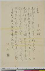
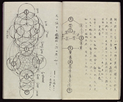
「本てうし とひ梅」
長篠合戦図屏風

「正月三日御拵絵図」
Safō
和国諸職絵尽

Haratamiki jikihitsushokan chibakaigannoshi

「兵庫県下里村一乗寺観音堂平面図」

「京都府府中村成相寺観音堂平面図(畳物)」
.jpg)
「加賀国金沢城内絵図及歴代城主」

Niikawagunshimagumikamegaiaramachimuraryouezu

Houjouzushitaezu

Kurikakifuusonkakiage

Etchuunokuninouchiniikawagunkaiganezu
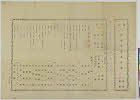
Kitagawareishunhyoumi2gatsuhaikaisurimono
Last Updated: 2020-06-05
Uploaded: 2021-07-22