Maritime territorial disputes in East Asia: a comparative analysis of the South China Sea and the ...
- People
- Time
- Owner Organization

South China Sea. South East Asia - Selected Areas. Pergamon World Atlas. Pergamon Press, Ltd. & P....
Stanford University Libraries
Stanford Libraries SearchWorks

The Senkaku/Diaoyu Islands Territorial Dispute between Japan and China: Between the Materializatio...
Complutense University Library of Madrid
Europeana API

The territorial dispute in the Sea of Japan and its impact on regional security
National Library of Serbia
Europeana API
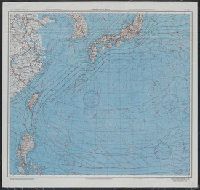
AAF cloth chart ; no. C-52, C-53
Yale University Library
Yale University Library Digital Collections
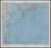
Japan and South China Seas / prepared at the direction of the commanding general, Army Air Forces, for the A...
Yale University Library
Yale University Library Digital Collections
Chiefs of South-east Asia Command drawing up the surrender terms to be fonifarded to the Japanese in their a...
National Library of New Zealand
DigitalNZ New Zealand API
Innovativeness and development in the economies of Japan, Korea and China. A comparative approach....
Dolnośląska Biblioteka Cyfrowa
Europeana API
A Chart of the Northern Part of the China Sea [Material cartográfico] : shewing the Passage from F...
Biblioteca Nacional de España
Europeana API

A new chart of the Pacific Ocean : exhibiting the western coast of America, from Cape Horn to Beerings Strait, the eastern shores of Asia including Japan, China and Australia and all the numerous islands and known dangers situated in Polynesia and Australasia / correctly drawn and regulated according to the most approved and modern surveys and astronomical observations by J.W. Norie
State Library of New South Wales
Trove: National Library of Australia
Last Updated:
Uploaded: 2021-07-27