A chart of the eastermost part of the East Indies with all the adjacent islands from Cape Comorin to Iapan / by Iohn Seller, Hydrographer to the King
- Time
- Owner Organization

A chart of the eastermost part of the East Indies with all the adjacent islands from Cape Comorin to Iapan / by Iohn Seller, Hydrographer to the King ; F. Lamb Sculp

A chart of the easternmost part of the East Indies with all the adjacent islands from Cape Comorin...
A chart of ye eastermost part of the East Indies / by Iohn Seller
A chart of the South Sea / by John Seller, Hydrographer to the Kings most Excellent Majestie ; Dundee, sculp

A Chart of the Eastermost part of the East Indies and China from Cape Comarin to Japan with the Ad...

A Chart of the Eastermost part of the East Indies and China from Cape Comarin to Japan with the Ad...

A chart of the tradeing part of the East Indies and China, with the adjacent islands, from Surrat ...

A New Chart of The Pacific Ocean, Exhibiting The Western Coast of America from Cape Horn to Beerin...

A New Chart of The Pacific Ocean, Exhibiting The Western Coast of America, From Cape Horn To Beeri...

A New Chart of The Pacific Ocean, Exhibiting The Western Coast of America, From Cape Horn To Beeri...
A New Chart of The Pacific Ocean, Exhibiting The Western Coast of America, From Cape Horn To Beeri...

A Map of the East-Indies and the Adjacent Countries; with the Settlements, Factories and Territori...

A Map of the East-Indies and the Adjacent Countries; with the Settlements, Factories and Territori...

A Map of the East-Indies and the Adjacent Countries; with the Settlements, Factories and Territori...

A Map of the East-Indies and the Adjacent Countries; with the Settlements, Factories and Territori...

A Map of the East-Indies and the Adjacent Countries; with the Settlements, Factories and Territori...

A Map of the East-Indies and the Adjacent Countries; with the Settlements, Factories and Territori...

Laurie and Whittle's New Chart of the Indian and Pacific Oceans Between the Cape of Good Hope, New...

Laurie and Whittle's New Chart of the Indian and Pacific Oceans Between the Cape of Good Hope, New...
A new & correct chart of the Indian Sea from Cabo Bonea Esperanca to Japan according to Mr. Edward Wrights projection vulgarly called Mercators chart
A chart of the South Sea / by J. Seller, J. Colson, W. Fisher, J. Atkinson & J. Thornton ; Dundee, sculp

(Upper Sheet to) Map of the Island of Japan, Kurile &c. with the Adjacent Coasts of the Chinese Do...

(Lower Sheet to) Map of the Island of Japan, Kurile &c. with the Adjacent Coasts of the Chinese Do...
A New & Correct Chart of the Indian Sea From Cabo Bonea Esperanca to Japan [Material cartográfico]...
Nieuwe wassende graet kaert van Oost Indien van d. C. d Bono Esperanca tot t'Lant Eso / gedruckt by I. Robyn met Privilege
Laurie and Whittle's new chart of the Indian and Pacific Oceans between the Cape of Good Hope, New Holland and Japan : comprehending New Zealand, New Caledonia, New Britain, New Ireland, New Guinea &c., Louisiade and New Georgia; also The Pelew, New Caroline, Ladrone and Philippine Islands &c. with the most remarkable tracks of the English, Spanish, French and Dutch navigators and chiefly the track of the Walpole, EastIndiaman, Captn. Thos. Butler, 1794 from the Cape of Good Hope to Van Diemen's Land and from thence to China, and the track of the Royal Admiral Captn. Henr. Bond in 1792 and 93 from the Cape to Port Jackson and China
Encyclopedia of Western Art : [volume 4]
Illustrated Proverbs, The Illustrated Lives of Women : [final volume]
Zeekaart van het oostelijk deel van de Indische Oceaan, van India tot Australië en Japan
Illustrated Book of Kyōka (comic poems) "Maple Bridge"
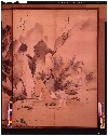
The Mountains of Husband and Wife

Carte réduite de l'Océan oriental depuis le Cap de Espérance jusqu'au Japon / Par Mr. d'Après de M...
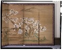
観桜図屏風
Goitsu Picture Album: Quick Practice for Beginners
![[Lotus plants in various stages of development]](https://tile.loc.gov/storage-services/service/pnp/jpd/02400/02435_150px.jpg)
[Lotus plants in various stages of development]
True Reflections on the Life and Manners of a Woman : [volumes 1-3]
Laurie and Whittle's New Chart of the Indian and Pacific Oceans Between the Cape of Good Hope, New...
Laurie and Whittle's New Chart of the Indian and Pacific Oceans Between the Cape of Good Hope, New...
Japanese Empire--802 M

Carte réduite de l'Ocean Oriental depuis le Cap de Bonne Espérance jusqu'au Japon / dressée sur le...
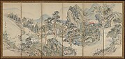
蘭亭曲水図屏風
Itchō Picture Album : [volume 3]
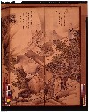
Orchid Pavilion Gathering; Autumn Harvest Festival
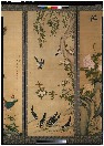
花鳥図屏風
蘭亭曲水図屏風
Chats on Novelties of Foreign Lands : [volume 4]

Carte de la Tartarie chinoise et des pays limitrophes / dressée sur les observations du P. de Mail...
A Garden of Celebrated Japanese and Chinese Paintings : [volume 6]
Last Updated: 2020-06-05
Uploaded: 2021-07-22