
Ryukyu Islands roads, railroads and cables

Ryukyu Islands, orientation
スタンフォード大学図書館
スタンフォード大学図書館SearchWorks

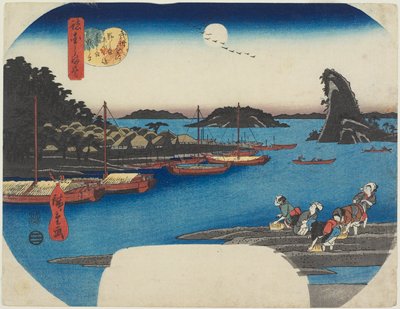
Evening Moon at Izumizaki (Izumizaki yagetsu), from the series “Eight Views of Ryukyu Islands (Ryukyu hakkei)”
シカゴ美術館
シカゴ美術館API

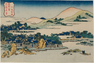
Banana Garden at Nakashima (Nakashima shoen), from the series "Eight Views of the Ryukyu Islands (Ryukyu hakkei)"
シカゴ美術館
シカゴ美術館API

Evening Moon at Izumizaki (Izumizaki yagetsu), from the series "Eight Views of the Ryukyu Islands (Ryukyu hakkei)"
シカゴ美術館
シカゴ美術館API

Japan : railroads and railroad facilities
イェール大学図書館
イェール大学図書館デジタルコレクション

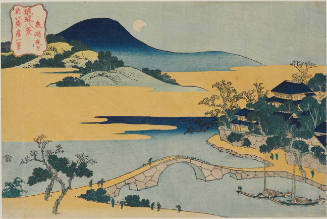
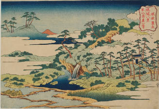
Evening Glow at Jungai (Jungai sekisho), from the series "Eight Views of the Ryukyu Islands (Ryukyu hakkei)"
シカゴ美術館
シカゴ美術館API

The Sound of Wind in the Pines at Ryuto (Ryuto shoto), from the series "Eight Views of the Ryukyu Islands (Ryukyu hakkei)"
シカゴ美術館
シカゴ美術館API
![Japan [cartographic material] : railroads and railroad facilities](https://stacks.stanford.edu/image/iiif/yv242dj2410%2Fyv242dj2410_00_0001/full/!200,200/0/default.jpg)
Japan [cartographic material] : railroads and railroad facilities
スタンフォード大学図書館
スタンフォード大学図書館SearchWorks

Figures and descriptions of the fishes of Japan : including Riukiu Islands, Bonin Islands, Formosa...
スミソニアン図書館
ヨーロピアナAPI

Okinawa Mem-O-Map part of the Ryukyu Islands. Drawn by T/4 John G. Drury 214th_ Ordnance Battalion...
スタンフォード大学図書館
スタンフォード大学図書館SearchWorks
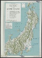
Central Japan (central and northern Honshu) : roads and water routes
イェール大学図書館
イェール大学図書館デジタルコレクション

Southwest Japan (Kyūshū, Shikoku, and southwest Honshū), railroads and railroad facilities [cartog...
スタンフォード大学図書館
スタンフォード大学図書館SearchWorks
SCAPIN-2102: INTERNATIONAL POSTAL SERVICE BETWEEN JAPAN AND THE RYUKYU ISLANDS 1950/06/13
国立国会図書館デジタルコレクション
国立国会図書館デジタルコレクション

South Pacific Ocean : Islands and Anchorages in Cook Islands
スタンフォード大学図書館
スタンフォード大学図書館SearchWorks
Banana Garden at Chūtō (Chūtō shōen), from the series Eight Views of the Ryūkyū Islands (Ryūkyū hakkei)
ハーバード美術館
ハーバード美術館API
![[Railroads in China, Manchuria, Korea, Japan and the eastern U.S.S.R.] [cartographic material]](https://stacks.stanford.edu/image/iiif/pf710vm7134%2Fpf710vm7134_00_0001/full/!200,200/0/default.jpg)
[Railroads in China, Manchuria, Korea, Japan and the eastern U.S.S.R.] [cartographic material]
スタンフォード大学図書館
スタンフォード大学図書館SearchWorks
Banana Groves at Nakashima (Nakashima Shōen), series Eight Views of the Ryūkyū Islands (琉球八景)
ホノルル美術館
ホノルル美術館コレクション
Nojima, Eboshijima, Natsushima, and Sarushima--Islands off Kanazawa in Bushū Province
ミネアポリス美術館
ミネアポリス美術館API
The Islands of Japan with Corea, Manchooria and the russian territory on the Amoor
ポーランド国立図書館
ヨーロピアナAPI
Night Moon at Izumizaki (Izumizaki Yagetsu), series Eight Views of the Ryūkyū Islands (琉球八景)
ホノルル美術館
ホノルル美術館コレクション

China and Japan. (with) Islands of Japan. By Keith Johnston, F.R.S.E. Keith Johnston's General Atl...
スタンフォード大学図書館
スタンフォード大学図書館SearchWorks
New Zealand soldiers and gun, Mono Island, Solomon Islands, during World War II
アレクサンダー・ターンブル図書館
デジタル・ニュージーランドAPI
2 NZ Divison transport on the rain soaked and muddy roads of the Italian Front, World War II - Photograph ta...
アレクサンダー・ターンブル図書館
デジタル・ニュージーランドAPI
Sacred Fountain at Jōgaku (Jōgaku Reisen), series Eight Views of the Ryūkyū Islands (琉球八景)
ホノルル美術館
ホノルル美術館コレクション

Chart of Discoveries made in 1787, in the Seas of China and Tartary, by the Boussole and Astrolabe...
スタンフォード大学図書館
スタンフォード大学図書館SearchWorks

Ryōtō Kaiwan : Daitzu Shan to Fuchou Chao
スタンフォード大学図書館
スタンフォード大学図書館SearchWorks

New Guinea - South Coast. Freshwater Bay to C. Blackwood
スタンフォード大学図書館
スタンフォード大学図書館SearchWorks

Japan distribution of waterworks
スタンフォード大学図書館
スタンフォード大学図書館SearchWorks

Approach to West Coast of Gazelle Peninsula
スタンフォード大学図書館
スタンフォード大学図書館SearchWorks
「紫式部 けんじかるた」」
Nationaal Museum van Wereldculturen (Rijksmuseum Volkenkunde, Leiden)
ARC浮世絵ポータルデータベース
![昭和16年12月23日. - [Tokyo] : [Japan Hydrographic Department], 1943.](https://stacks.stanford.edu/image/iiif/tr362bp8983%2Ftr362bp8983_00_0001/full/!200,200/0/default.jpg)
昭和16年12月23日. - [Tokyo] : [Japan Hydrographic Department], 1943.
スタンフォード大学図書館
スタンフォード大学図書館SearchWorks

Central Portion of Sumbawa with Pulo Tenga Islands
スタンフォード大学図書館
スタンフォード大学図書館SearchWorks

Empire of Japan . .
スタンフォード大学図書館
スタンフォード大学図書館SearchWorks

「西国第八番大和長谷寺観音堂平面図」「他(畳物)」
東京都立中央図書館
ARC浮世絵ポータルデータベース

Plans of Anchorages in Witu Islands
スタンフォード大学図書館
スタンフォード大学図書館SearchWorks

「淡路州?盧島方角略図(蜂屋正盛写)」
東京都立中央図書館
ARC浮世絵ポータルデータベース
![[Russian Map of Northeastern Asia, Japan, Korea, China, Alaska, etc.] ( Summary map of hydrographi...](https://stacks.stanford.edu/image/iiif/pj697kr2558%2F35405/full/!200,200/0/default.jpg)
[Russian Map of Northeastern Asia, Japan, Korea, China, Alaska, etc.] ( Summary map of hydrographi...
スタンフォード大学図書館
スタンフォード大学図書館SearchWorks
最終更新日: 2020-04-17
登録日: 2021-09-21