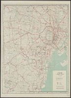
City map, central Tokyo. December 1946 / prepared under direction of the chief engineer, general headquarter...
- People
- Time
- Owner Organization
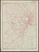
City map, central Tokyo. October 1947 / prepared under direction of the chief engineer, GHQ, FEC, byt the 64...
Yale University Library
Yale University Library Digital Collections
City map, central Tokyo / prepared under the direction of the Engineer, GHQ, FEC ; by the 64th Engineer Base Topographic Battalion
National Library of Australia
Trove: National Library of Australia
City map, central Tokyo / prepared under the direction of Office of the Engineer, HQ, AFFE, by the 64th Engineer Battalion (Base Topographic)
National Library of Australia
Trove: National Library of Australia
Yokohama city map : corrected to May 1954 / prepared under the direction of Office of the Engineer, AFFE, by the 29th Engineer Battalion (Base Topographic)
National Library of Australia
Trove: National Library of Australia
Map of central Tokyo / prepared for the 64th Engineer Topographic Battalion for GHQ Visitors Bureau
Yale University Library
Yale University Library Digital Collections
![City map, central Tokyo, advance edition [cartographic material].](https://stacks.stanford.edu/image/iiif/rr820wk0562%2Frr820wk0562_0001/full/!200,200/0/default.jpg)
City map, central Tokyo, advance edition [cartographic material].
Stanford University Libraries
Stanford Libraries SearchWorks
Central Japan 1:500,000 / prepared under the direction of the Engineer, U.S. Sixth Army, AFPAC, by the 650th Engineer TOP. BN., August 1945
National Library of Australia
Trove: National Library of Australia
Series ; 5207
Yale University Library
Yale University Library Digital Collections

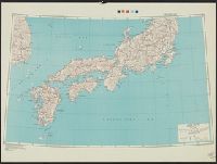
Japan road map, 1:1,000,000 / prepared under the direction of the Chief of Engineers, U.S. Army by the Army ...
Yale University Library
Yale University Library Digital Collections
Japan road map 1:1,000,000. sheet 4, Korea / prepared under the direction of the Chief of Engineers, U.S. Ar...
Yale University Library
Yale University Library Digital Collections
East Asia and North Pacific 1:4,350,000 / prepared under the direction of the Chief of Engineers by the Army Map Service (AM) ; U.S. Army, Washington, D.C
National Library of Australia
Trove: National Library of Australia
Handbook to the colony of Victoria / prepared under the direction of the Victorian Government by Henry Heylyn Hayter
National Library of Australia
Trove: National Library of Australia
The story of Japanese farming in California. Prepared under the direction of Emil T. H. Bunje. Ber...
University of California Libraries
Europeana API
The story of Japanese farming in California. Prepared under the direction of Emil T. H. Bunje. Ber...
University of California Libraries
Europeana API
Japan 1:500,000 / prepared under the direction of the Engineer, U.S. Sixth Army by the 69th EngineerTopo. Co., July 1945 ; reproduced by BMP no 1, GHQ. AFPAC, U.S. Army
National Library of Australia
Trove: National Library of Australia
Caroline Islands 1:25,000 : Yap / prepared under the direction of Engineer, Hq AFFE/BA, by the Military Geology Branch, Intelligence Division ; map compiled by C. G. Johnson, geologist, Military Geology Branch, U.S. Geological Survey, for the Intelligence Division, Office of the Engineer, Hq. U.S. Army Japan
National Library of Australia
Trove: National Library of Australia
AAF cloth chart ; no. C-52, C-53
Yale University Library
Yale University Library Digital Collections
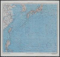
Japan and South China Seas / prepared at the direction of the commanding general, Army Air Forces, for the A...
Yale University Library
Yale University Library Digital Collections
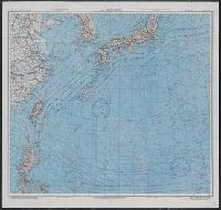
Japan and South China Seas / prepared at the direction of the commanding general, Army Air Forces, for the A...
Yale University Library
Yale University Library Digital Collections
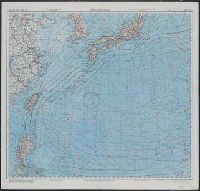
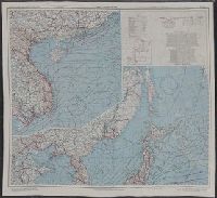
East China Sea
Yale University Library
Yale University Library Digital Collections

East China Sea
Yale University Library
Yale University Library Digital Collections
City map, central Tokyo. October 1947 / prepared under direction of the chief engineer, GHQ, FEC, byt the 64...
Yale University Library
Yale University Library Digital Collections

Tokyo
Yale University Library
Yale University Library Digital Collections
City map, central Tokyo, advance edition [cartographic material].
Stanford University Libraries
Stanford Libraries SearchWorks

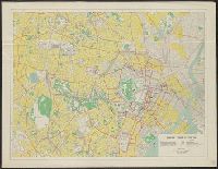
Central Tokyo : city map.
Stanford University Libraries
Stanford Libraries SearchWorks

Provinces of Kansu and Ninghsia : Board of Economic Warfare / drawn in R. and A., O.S.S
Yale University Library
Yale University Library Digital Collections

Carte Des Missions Cathliques au Japan . . . 1898 (China and Formosa related insets)
Stanford University Libraries
Stanford Libraries SearchWorks
![Tokyo city proper [cartographic material]](https://stacks.stanford.edu/image/iiif/vj067cj0650%2Fvj067cj0650_00_0001/full/!200,200/0/default.jpg)
Tokyo city proper [cartographic material]
Stanford University Libraries
Stanford Libraries SearchWorks
![Indo Hyakumanbunnoichi Zu Tōbu Shūiki [cartographic material]](https://stacks.stanford.edu/image/iiif/wr290sd1084%2Fwr290sd1084_00_0001/full/!200,200/0/default.jpg)
Indo Hyakumanbunnoichi Zu Tōbu Shūiki [cartographic material]
Stanford University Libraries
Stanford Libraries SearchWorks

Niman gosenbun no ichi tōbu So-ryō shigaizu
Stanford University Libraries
Stanford Libraries SearchWorks

The New War Map of Maryland Part of Virginia & Pennsylvania. Published by B.B. Russell . .
Stanford University Libraries
Stanford Libraries SearchWorks

Nagasaki
Yale University Library
Yale University Library Digital Collections
![Map of Manchuria, Corea & Japan [cartographic material]](https://collections.library.yale.edu/iiif/2/15828540/full/!200,200/0/default.jpg)
Map of Manchuria, Corea & Japan [cartographic material]
Yale University Library
Yale University Library Digital Collections
A New Chart of the Indian and Pacific Oceans Between the Cape of Good Hope, New Holland, and Japan...
Biblioteca Nacional de España
Europeana API

Military Map of South-Eastern Virginia
Stanford University Libraries
Stanford Libraries SearchWorks
Japan and adjacent regions / prepared and distributed by Army Information Branch, Army Service Forces
Yale University Library
Yale University Library Digital Collections

Kita Karafuto niman-gosenbun no ichizu
Stanford University Libraries
Stanford Libraries SearchWorks

Nara, Yamada, Koyasan, & environs
Yale University Library
Yale University Library Digital Collections

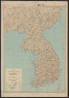
Map of Chosen (Korea)
Yale University Library
Yale University Library Digital Collections
![Kuwana kōkū shashin sokuryōzu [cartographic material]](https://stacks.stanford.edu/image/iiif/sp849hm7726%2Fsp849hm7726_00_0001/full/!200,200/0/default.jpg)
Kuwana kōkū shashin sokuryōzu [cartographic material]
Stanford University Libraries
Stanford Libraries SearchWorks

Tetsudō senro ryakuzu
Stanford University Libraries
Stanford Libraries SearchWorks

Ogaki, Gifu Prefecture, Honshu, Japan
Stanford University Libraries
Stanford Libraries SearchWorks
![Tsu-shi kōkū shashin sokuryōzu [cartographic material]](https://stacks.stanford.edu/image/iiif/nw380zf1798%2Fnw380zf1798_00_0001/full/!200,200/0/default.jpg)
Tsu-shi kōkū shashin sokuryōzu [cartographic material]
Stanford University Libraries
Stanford Libraries SearchWorks

Hyakumanbun no ichi Nanpō kōkūzu
Stanford University Libraries
Stanford Libraries SearchWorks

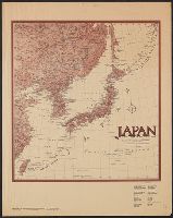
The Japanese empire : with central and southern Manchukuo (Manchuria)
Yale University Library
Yale University Library Digital Collections
Last Updated: 2021-01-30
Uploaded: 2021-07-29