
Map of Colorado Territory, Compiled from Government Maps & Actual Surveys. Made In 1861
- People
- Time
- Owner Organization

Map of Colorado Territory, Compiled from Government Maps & Actual Surveys. Made In 1861

Map of Colorado Territory, Compiled from Government Maps & Actual Surveys. Made In 1861

Map of Colorado Territory, Compiled from Government Maps & Actual Surveys. Made In 1861

A Correct Map From Actual Surveys And Examinations Embracing A Portion of California Between Monte...

Lloyd's Official Map of the State of Tennessee Compiled From Actual Sureys and Official Documents ...

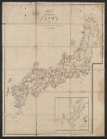
General map of the Government Railways in Japan

Japan, Gulf of Ösaka, Hiogo and Ösaka compiled from British and French surveys to 1878

Stanford's library Map of Japan / principally compiled from japanese documents, by E. Knipping

Cannon's Map of the Mineral Belt of Colorado Taken from the Records of the Surveyor General's Offi...

map from "The Claims of Japan and Malaysia upon Christendom exhibited in notes of voyages made in ...

map from "The Claims of Japan and Malaysia upon Christendom exhibited in notes of voyages made in ...

Map of China And the Surrounding Regions. Compiled from the latest information by E. Bretscheider....

Japan : South coast of Honshu : Gulf of Tokyo or Yedo. Compiled from Japanese Government, and Brit...

A New and Accurate Map of the World. Drawn from the best Surveys and regulated by Astronomical Obs...

A New and Accurate Map of the Colony of Massachusets Bay, In North America from a Late Survey

A New and Accurate Map of the Colony of Massachusets Bay, In North America from a Late Survey

map from "Japan in Transition. A comparative study of the progress, policy, and methods of the Jap...

map from "Japan in Transition. A comparative study of the progress, policy, and methods of the Jap...
A new map of the empires, states, provinces &c of Asia : including also the Turkish & Russian dominions in Europe & New Holland / compiled from the most authentic observations by Robert Wilkinson ; Walsh script. ; W. Palmer sculpt
The Suma oriental of Tomé Pires : an account of the East from the Red Sea to Japan, written in Malacca and India in 1512-1515; and, The Book of Francisco Rodrigues, rutter of a voyage in the Red Sea, nautical rules, almanack and maps written and drawn in the East before 1515 (Map in pocket of vol.2: The east, from the Red Sea to Japan, as known to Francisco Rodrigques)
Tsunamis in the Pacific Basin, 1900-1983 / map produced by Patricia A. Lockridge, National Geophysical Data Center and Ronald H. Smith, Cooperative Institute for Research in Environmental Sciences ; published by National Geophysical Data Center and World Data Center A for Solid Earth Geophysics with support from Office of U.S. Foreign Disaster Assistance, Agency for International Development in cooperation with Circum-Pacific Council for Energy and Mineral Resources, Map Project
The country trade East-India pilot, for the navigation of the East-Indies and oriental seas, within the limits of the East-India Company, extending from the Cape of Good Hope to China, New Holland and New Zeeland, with the Red Sea, Gulf of Persia, Bay of Bengal, and China Seas / chiefly composed from actual surveys and draughts communicated by experienced officers of the East-India Company, and from the Neptune oriental by M. d'Apres de Mannevillette
Map of Colorado Territory, Compiled from Government Maps & Actual Surveys. Made In 1861
Map of Colorado Territory, Compiled from Government Maps & Actual Surveys. Made In 1861
Carte de L'Empire du Japon ..

Kaetsunousanshuugunwakeryakuezu

Kuniyoshi's preparatory drawings, no.48
Gōshū shūikizu : Roppyakumanbun no ichi
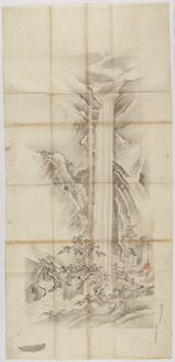
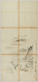
探幽/瀧図
愛知県地図 : 愛知県地図
Stanford's map of eastern China, Japan and Korea : the seat of war in 1894
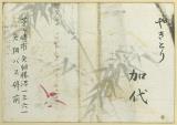
やきとり 加代

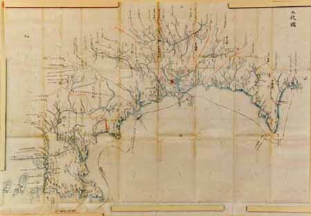
伊勢海及三河湾附近沿岸 : 海軍海図日本総部図付海図目録

Laurie and Whittle's New Chart of the Indian and Pacific Oceans Between the Cape of Good Hope, New...

習志野演習場

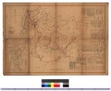
佐賀県管内図

Lustgarten des Shugakuin-Tempels, Kyoto

Picture Book: Selected Insects
探幽/須磨明石図
Nijūgomanbun no ichi Papua-tō Sepikku-gawa ryūiki zu (Sheet 1)
富士山頂上八峯内院并諸国遠見図

佐賀県管内全図(表)
Tosanokunizu

Mer Orientale, où l'on trouve l'isle de Jedso, de laquelle on doutoit si c'étoit une isle ou non

Kuniyoshi's preparatory drawings, no.48

Kersebloesemtak, kraanvogels en een ornament
Last Updated: 2020-04-17
Uploaded: 2021-09-21