
Guide to Tokyo City
- Time
- Owner Organization

New railway map of Tokyo and vicinity. Published by Japan Guide Map Co., Ltd. Compiled and printed...

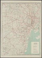
Map of Tokyo : city communications
Mino Shigyo Co., Ltd. Silkscreen Printing

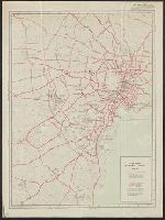
Central Tokyo : city map.
Map of Yokohama / North and Rae Ltd
Ampol Pacific map / with the compliments of Australian Motorists Petrol Co. Ltd. ; published Gregory Publishing Co. ; copyright C. Barrass
Tokyo and vicinity : showing bombed-out areas / prepared ... by Nippon Map Co
City map, central Tokyo / prepared under the direction of the Engineer, GHQ, FEC ; by the 64th Engineer Base Topographic Battalion

The Guide Map to the Railway in The Neighbourhood of Tokyo
City map, central Tokyo. December 1946 / prepared under direction of the chief engineer, general headquarter...
City map, central Tokyo / prepared under the direction of Office of the Engineer, HQ, AFFE, by the 64th Engineer Battalion (Base Topographic)
Ägare:/196 -69/: Japan Line, Ltd. Hemort: Tokyo

(Covers to) Picture map of China. Designed by Frank Randolph Southard. Printed in United States of...
Map of the missionary districts of north Tokyo & Kyoto : under the jurisdiction of the Bishop of Tokyo 1895
Tokyo : Tokyo Railway system/ June 2015. Designed + produced by Zero Per Zero. Printed in Korea
City map, central Tokyo. October 1947 / prepared under direction of the chief engineer, GHQ, FEC, byt the 64...
Picture map of China. Designed by Frank Randolph Southard. Printed in United States of America. (C...

Picture map of China. Designed by Frank Randolph Southard. Printed in United States of America. (C...
Map of Tokyo, featuring subway system. Copy rights by Creative Associates, Tokyo, Japan, (May 1975...
Bilingual map of Greater Tokyo. Prepared by the Cartographic Division of King Associates. Publishe...

Map of Asia
Tokyo metropolitan Railway system. Designed and produced by Zero Per Zero. Printed in Korea
Page with drawings of funnel and house flag of Nippon Yushen Kabushiki Kaisha, [NYKK]; Japan Mail SSCo Ltd, Tokyo

Japan. Copyright 1892 by Appleton & Co. (insets) Kurile Islands; Tokyo. (to accompany) The Library...

Celebes - West Coast : Cape William to Tandyung Karang
![[Russian Map of Northeastern Asia, Japan, Korea, China, Alaska, etc.] ( Summary map of hydrographi...](https://stacks.stanford.edu/image/iiif/pj697kr2558%2F35405/full/!200,200/0/default.jpg)
[Russian Map of Northeastern Asia, Japan, Korea, China, Alaska, etc.] ( Summary map of hydrographi...

Jūmanbunnoichi Guamutō fukin

North Pacific Ocean : Eastern Part of Hawaiin Islands

Togian Isles to Peleng Strait

Japan, political divisions

Japan : distribution of waterworks

Rice areas in Japan

Saipantō

Approach to West Coast of Gazelle Peninsula

Japan distribution of waterworks

Carta General para las Navegaciones a la India Oriental por el Mar del Sur y el Grande Oceano que ...

Japan : railroads and railroad facilities

Eastern Portion of Flores to Lomblem

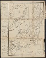
(Map of Hokkaido, Japan). (to accompany) Shomitsu Nippon chizu. (Atlas of Japan) Nippon Shoin. (To...

Map of Kyoto and vicinity

Eastern Archipelago : Flores Sea. Tana Jampea and Adjacent Islands

Niihama, Ehime Prefecture, Shikoku, Japan

Durville Island and Approaches

Straits between Sumbawa, Flores and Sumba

Eastern Archipelago : Celebes - East Coast. Tg. Losoni to Northern Entrance to Buton Str.

Central Portion of Sumbawa with Pulo Tenga Islands

Mar Del Zur Hispanis Mare Pacificum (Rare 2nd State with Tasman's Discoveries)
![Kasei Kita Shina jūmanbun no ichi zu. Hsüchow (Xuzhou) [cartographic material]](https://stacks.stanford.edu/image/iiif/js550gn2130%2Fjs550gn2130_00_0001/full/!200,200/0/default.jpg)
Kasei Kita Shina jūmanbun no ichi zu. Hsüchow (Xuzhou) [cartographic material]
Last Updated: 2021-01-30
Uploaded: 2021-07-29