Esso war map III featuring the Pacific Theater : a third war map / edited, drafted and printed by the makers...
Esso war map III featuring the Pacific Theater : a third war map / edited, drafted and printed by the makers...
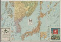
Esso war map III featuring the Pacific Theater : a third war map / edited, drafted and printed by the makers...
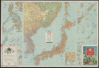
Esso war map III featuring the Pacific Theater : a third war map / edited, drafted and printed by the makers...
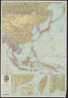
Esso war map III featuring the Pacific Theater : a third war map / edited, drafted and printed by the makers...

The war against Japan (Japanese & Pacific Map)
War map : Australia, China, Japan, and the South Pacific / Cyril Dillon
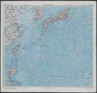
![[World War II battlefronts]. Map VI. The Southwest Pacific. Copyright, 1944, by Remington Rand, In...](https://stacks.stanford.edu/image/iiif/vs321mz7073%2F6758006/full/!200,200/0/default.jpg)
[World War II battlefronts]. Map VI. The Southwest Pacific. Copyright, 1944, by Remington Rand, In...
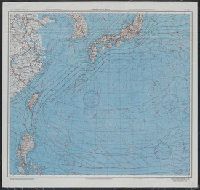
Theater of war in the Pacific Ocean / compiled and drawn in the Cartographic Section of the National Geographic Society for the National Geographic Magazine
Theater of war. Episode 2, Under attack, Pearl Harbor [electronic resource] : the Pacific campaign
Theater of war. Episode 4, Victory at sea, America fights back [electronic resource] : the Pacific...
Pacific war map / Dept. of Home Security ; issued by authority of the Minister for Home Security with the permission of Associated Newspapers Ltd

The New War Map of Maryland Part of Virginia & Pennsylvania. Published by B.B. Russell . .

On December 7, 1941, Japan struck the first treacherous, devastating blow of the pacific war. Sneaking in fr...
Submarines for sale. Four of the seven American submarines, all boasting outstanding Pacific war records, no...
Esso war map III featuring the Pacific Theater : a third war map / edited, drafted and printed by the makers...
Esso war map III featuring the Pacific Theater : a third war map / edited, drafted and printed by the makers...
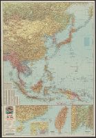
![Japan and adjacent regions of Asia and the Pacific Ocean [cartographic material] / compiled and drawn in the...](https://collections.library.yale.edu/iiif/2/15510875/full/!200,200/0/default.jpg)
Japan and adjacent regions of Asia and the Pacific Ocean [cartographic material] / compiled and drawn in the...

Rand, McNally & Co.'s 1904 war map of Japan, Korea, and China ; Rand, McNally & Co.'s 1904 war map of Russia...
Esso war map III featuring the Pacific Theater : a third war map / edited, drafted and printed by the makers...
![Far East, Japanese occupied area, major railroads [cartographic material] / Board of Economic Warfare, Enemy...](https://collections.library.yale.edu/iiif/2/15510697/full/!200,200/0/default.jpg)
Far East, Japanese occupied area, major railroads [cartographic material] / Board of Economic Warfare, Enemy...

Japan and Korea / compiled and drawn in the Cartographic Section of the National Geographic Society ; James ...
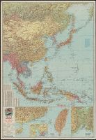
![Japan and adjacent regions of Asia and the Pacific Ocean [cartographic material] / compiled and drawn in the...](https://collections.library.yale.edu/iiif/2/15509964/full/!200,200/0/default.jpg)
Japan and adjacent regions of Asia and the Pacific Ocean [cartographic material] / compiled and drawn in the...
Esso war map III featuring the Pacific Theater : a third war map / edited, drafted and printed by the makers...

Russisch-japanischer Kriegsschauplatz. Karte II, Süd-Mandschurei, Korea, Nordost-China

Japan and South China Seas / prepared at the direction of the commanding general, Army Air Forces, for the A...

The topographic map of Manchoukuo

Asie Orientale comprenant L'Empire Chinois et le Japon Les Etats De L'Indo-Chine et le Grand Archi...

大滿洲國詳圖
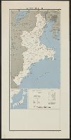
Japan, Mie-ken
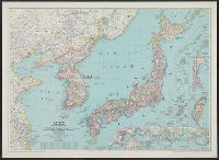
Japan and Korea / compiled and drawn in the Cartographic Section of the National Geographic Society ; James ...

The Japanese empire : with central and southern Manchukuo (Manchuria)

Nagasaki
Japan and South China Seas / prepared at the direction of the commanding general, Army Air Forces, for the A...

Chinese Empire (including Trans Oceanic Cables to Hong Kong,etc.)

五十万分一後貝加爾方面素圖.

Rand, McNally & Co.'s 1904 war map of Japan, Korea, and China ; Rand, McNally & Co.'s 1904 war map of Russia...
Japan and South China Seas / prepared at the direction of the commanding general, Army Air Forces, for the A...

Cannon's Map of the Mineral Belt of Colorado Taken from the Records of the Surveyor General's Offi...
最終更新日: 2021-01-30
登録日: 2021-07-29