
The topographic map of Manchoukuo
- People
- Time
- Owner Organization
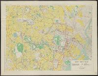
Map of central Tokyo / prepared for the 64th Engineer Topographic Battalion for GHQ Visitors Bureau
Yale University Library
Yale University Library Digital Collections

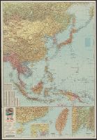
The latest map of Manchuria, Korea, Formosa, and Saghalien
Stanford University Libraries
Stanford Libraries SearchWorks

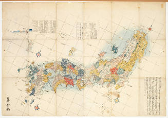
Map of the Empire of Japan
Salem State University Archives and Special Collections
DPLA API

Map of Manchuria, Corea & Japan
Boston Public Library
DPLA API
![[Empire Day if Manchoukuo.]](https://api.europeana.eu/api/v2/thumbnail-by-url.json?uri=http%3A%2F%2Fwww.beeldbankwo2.nl%2Fcgi-bin%2Ffrsiserver.dll%2Fthumbnail%2F100229-thumb.jpg%3Ffrskey%3D100229&type=IMAGE)
[Empire Day if Manchoukuo.]
NIOD Institute for War, Holocaust and Genocide Studies
Europeana API
City map, central Tokyo / prepared under the direction of the Engineer, GHQ, FEC ; by the 64th Engineer Base Topographic Battalion
National Library of Australia
Trove: National Library of Australia

(Composite Map of) Map of the Island of Japan, Kurile &c. with the Adjacent Coasts of the Chinese ...
Stanford University Libraries
Stanford Libraries SearchWorks
City map, central Tokyo / prepared under the direction of Office of the Engineer, HQ, AFFE, by the 64th Engineer Battalion (Base Topographic)
National Library of Australia
Trove: National Library of Australia

Map of the Pacific Ocean
Philadelphia Museum of Art
Philadelphia Museum of Art collection
![[Modern Map of the World]](https://stacks.stanford.edu/image/iiif/vc284tj9920%2F35672ll/full/!200,200/0/default.jpg)
[Modern Map of the World]
Stanford University Libraries
Stanford Libraries SearchWorks
Map of the Japanese Archipelago
Honolulu Museum of Art
Honolulu Museum of Art Collection

The railway map of Japan
Boston Public Library
DPLA API

Map of the Empire of Japan in 1914
New Zealand Ministry for Culture and Heritage
DigitalNZ New Zealand API
Map of Japan and Manchoukuo : issued with the Japan year book, 1938-39 / by T. Sasaki, Y. Nogi
National Library of Australia
Trove: National Library of Australia
Cook's map of the tourist districts of New South Wales
National Library of Australia
Trove: National Library of Australia
General map of China and adjacent regions, showing treaty ports and railways / prepared for the Department of State, by the Topographic Branch, U.S. Geological Survey
National Library of Australia
Trove: National Library of Australia
![[Map of China]](https://collections.library.yale.edu/iiif/2/16189150/full/!200,200/0/default.jpg)
[Map of China]
Yale University Library
Yale University Library Digital Collections
1 1/2 sen Map of the Empire of Japan
Gabinet Postal Museum of Barcelona (Col·lecció Marull)
Europeana API
Yokohama city map : corrected to May 1954 / prepared under the direction of Office of the Engineer, AFFE, by the 29th Engineer Battalion (Base Topographic)
National Library of Australia
Trove: National Library of Australia

Map of the State of New York Published by Charles Magnus
Stanford University Libraries
Stanford Libraries SearchWorks

Map of the State of New York Published by Charles Magnus
Stanford University Libraries
Stanford Libraries SearchWorks

Map of the State of New York Published by Charles Magnus
Stanford University Libraries
Stanford Libraries SearchWorks

Map of the State of New York Published by Charles Magnus
Stanford University Libraries
Stanford Libraries SearchWorks
![Bankokuzu Zen : [Complete map of the World]](https://stacks.stanford.edu/image/iiif/hd277ns8369%2Fhd277ns8369_05_0001/full/!200,200/0/default.jpg)
Bankokuzu Zen : [Complete map of the World]
Stanford University Libraries
Stanford Libraries SearchWorks

大滿洲國詳圖
Yoshida-South Library, Kyoto University
IIIF Discovery in Japan
![Manshūkoku yochizu [cartographic material] : hyakumanbun no ichi](https://stacks.stanford.edu/image/iiif/dc116hp3130%2Fdc116hp3130_00_0001/full/!200,200/0/default.jpg)
Manshūkoku yochizu [cartographic material] : hyakumanbun no ichi
Stanford University Libraries
Stanford Libraries SearchWorks
![Far East, Japanese occupied area, major railroads [cartographic material]](https://stacks.stanford.edu/image/iiif/zm881nj6799%2Fzm881nj6799_00_0001/full/!200,200/0/default.jpg)
Far East, Japanese occupied area, major railroads [cartographic material]
Stanford University Libraries
Stanford Libraries SearchWorks

Nemuro
Yale University Library
Yale University Library Digital Collections

Hyakumanbun no ichi Heiyō chiri chōsazu
Stanford University Libraries
Stanford Libraries SearchWorks

Hyakumanbunnoichi zu
Stanford University Libraries
Stanford Libraries SearchWorks
![Far East, Japanese occupied area, major railroads [cartographic material] / Board of Economic Warfare, Enemy...](https://collections.library.yale.edu/iiif/2/15510697/full/!200,200/0/default.jpg)
Far East, Japanese occupied area, major railroads [cartographic material] / Board of Economic Warfare, Enemy...
Yale University Library
Yale University Library Digital Collections
![Tokyo and vicinity, showing bombed-out areas [cartographic material]](https://stacks.stanford.edu/image/iiif/jx217xm7539%2Fjx217xm7539_00_0001/full/!200,200/0/default.jpg)
Tokyo and vicinity, showing bombed-out areas [cartographic material]
Stanford University Libraries
Stanford Libraries SearchWorks

Politisch-militärische Karte von Ost Asien zur Veranschaulichung der Kämpfe in China, Korea und Ja...
Bibliothèque nationale de France
Europeana API

Hitome de wakaru shina jihen to nisso kankei e chizu. (Drawn by) Eisuke Ishida. Showa 12 (1937). (...
Stanford University Libraries
Stanford Libraries SearchWorks
Hitome de wakaru shina jihen to nisso kankei e chizu. (Drawn by) Eisuke Ishida. Showa 12 (1937). (...
Stanford University Libraries
Stanford Libraries SearchWorks

U.S.S.R. - Far East, Korea, Japan. Pergamon World Atlas. Pergamon Press, Ltd. & P.W.N. Poland 1967...
Stanford University Libraries
Stanford Libraries SearchWorks

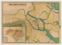
徳島市街全図
Tokushima Prefectural Library
ADEAC: A System of Digitalization and Exhibition for Archive Collections
Esso war map III featuring the Pacific Theater : a third war map / edited, drafted and printed by the makers...
Yale University Library
Yale University Library Digital Collections

Oga hanto. Tazawako, Japan. (to accompany) Shomitsu Nippon chizu. (Atlas of Japan) Nippon Shoin. (...
Stanford University Libraries
Stanford Libraries SearchWorks

Chinese Empire (including Trans Oceanic Cables to Hong Kong,etc.)
Stanford University Libraries
Stanford Libraries SearchWorks
徳島市街及び附近名勝
Tokushima Prefectural Library
ADEAC: A System of Digitalization and Exhibition for Archive Collections
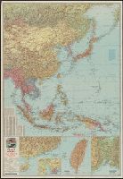
![Japan and adjacent regions of Asia and the Pacific Ocean [cartographic material] / compiled and drawn in the...](https://collections.library.yale.edu/iiif/2/15510875/full/!200,200/0/default.jpg)
Japan and adjacent regions of Asia and the Pacific Ocean [cartographic material] / compiled and drawn in the...
Yale University Library
Yale University Library Digital Collections

最新満州帝國大地圖
Yoshida-South Library, Kyoto University
IIIF Discovery in Japan

Russisch-japanischer Kriegsschauplatz. Karte II, Süd-Mandschurei, Korea, Nordost-China
Stanford University Libraries
Stanford Libraries SearchWorks
War map III featuring the Pacific Theater
Yale University Library
Yale University Library Digital Collections
![Japan and adjacent regions of Asia and the Pacific Ocean [cartographic material] / compiled and drawn in the...](https://collections.library.yale.edu/iiif/2/15509964/full/!200,200/0/default.jpg)
Japan and adjacent regions of Asia and the Pacific Ocean [cartographic material] / compiled and drawn in the...
Yale University Library
Yale University Library Digital Collections
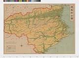
徳島県日本新分県地図
Tokushima Prefectural Archives
ADEAC: A System of Digitalization and Exhibition for Archive Collections

Ōso sangyō shigenzu
Stanford University Libraries
Stanford Libraries SearchWorks
Last Updated: 2020-04-17
Uploaded: 2021-09-21