
Rand, McNally & Co.'s 1904 war map of Russia and the continent of Asia
- People
- Time
- Owner Organization

1904 war map of Japan, Korea, and China
Yale University Library
Yale University Library Digital Collections

1904 war map of Russia and the continent of Asia
Yale University Library
Yale University Library Digital Collections

Rand, McNally & Co.'s China. Chinese Empire with Japan and Korea
Stanford University Libraries
Stanford Libraries SearchWorks

Map of Asia
Yale University Library
Yale University Library Digital Collections

Rand, McNally & Company's indexed atlas of the world map of Japan Copyright 1892, by Rand, McNally...
Stanford University Libraries
Stanford Libraries SearchWorks

Rand McNally map of Eastern Asia and Western Pacific Ocean. Mercator projection. Copyright by Rand...
Stanford University Libraries
Stanford Libraries SearchWorks

Special war map of China, Korea, and Japan
Stanford University Libraries
Stanford Libraries SearchWorks

(Covers to) Rand McNally map of Eastern Asia and Western Pacific Ocean Mercator projection. Copyri...
Stanford University Libraries
Stanford Libraries SearchWorks

Rand McNally map of Eastern Asia and Western Pacific Ocean. (Mercator projection). Copyright by Ra...
Stanford University Libraries
Stanford Libraries SearchWorks
Stanford's map of eastern China, Japan and Korea : the seat of war in 1894
National Library of Australia
Trove: National Library of Australia
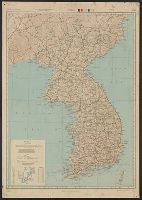
Map of Korea / prepared by Angus Hamilton F.R.G.S. 1904
National Library of Australia
Trove: National Library of Australia
Korean War 1950-1953 -- Asia, North Korea, South Korea, China, Manchuria, Japan Map / Maps.com(CR)
National Library of Australia
Trove: National Library of Australia
![[Russian Map of Northeastern Asia, Japan, Korea, China, Alaska, etc.] ( Summary map of hydrographi...](https://stacks.stanford.edu/image/iiif/pj697kr2558%2F35405/full/!200,200/0/default.jpg)
[Russian Map of Northeastern Asia, Japan, Korea, China, Alaska, etc.] ( Summary map of hydrographi...
Stanford University Libraries
Stanford Libraries SearchWorks

Bartholomew's special Map of China, Japan and Korea
Bibliothèque nationale de France
Europeana API

Bartholomew's Special Map of China, Japan and Korea
Bibliothèque nationale de France
Europeana API
MAP, OF THE SEAT OF WAR BETWEEN CHINA AND JAPAN; (Auckland Star, 22 September 1894)
National Library of New Zealand
DigitalNZ New Zealand API

The war against Japan (Map USSR, China & Australia)
Australian National Maritime Museum
Trove: National Library of Australia
![China and Japan [cartographic material]](https://collections.library.yale.edu/iiif/2/15828553/full/!200,200/0/default.jpg)
China and Japan [cartographic material]
Yale University Library
Yale University Library Digital Collections

[Transport Map of Russia: 'Map of the routes of Steamships, Communication lines, Railways and Road...
Stanford University Libraries
Stanford Libraries SearchWorks

Up-to-date map of the world war
Yale University Library
Yale University Library Digital Collections
THE RUSSO-JAPANESE WAR: TUG-OF-WAR. (Otago Witness, 11 May 1904)
National Library of New Zealand
DigitalNZ New Zealand API
"Daily Mail" map of the war in China / G. Philip & Son
National Library of Australia
Trove: National Library of Australia
[Japanese map of World War II]
National Library of Australia
Trove: National Library of Australia
[Japanese map of World War ll]
National Library of Australia
Trove: National Library of Australia

The Japanese empire : with central and southern Manchukuo (Manchuria)
Yale University Library
Yale University Library Digital Collections

Chinese Empire (including Trans Oceanic Cables to Hong Kong,etc.)
Stanford University Libraries
Stanford Libraries SearchWorks
1904 war map of Russia and the continent of Asia
Yale University Library
Yale University Library Digital Collections
Esso war map III featuring the Pacific Theater : a third war map / edited, drafted and printed by the makers...
Yale University Library
Yale University Library Digital Collections

Mandchourie et Coree de Kharbine a Seoul de Port-Arthur a Vladivostok Traduction de la Carte d'Eta...
Stanford University Libraries
Stanford Libraries SearchWorks

Nagasaki
Yale University Library
Yale University Library Digital Collections
![Japan and adjacent regions of Asia and the Pacific Ocean [cartographic material] / compiled and drawn in the...](https://collections.library.yale.edu/iiif/2/15510875/full/!200,200/0/default.jpg)
Japan and adjacent regions of Asia and the Pacific Ocean [cartographic material] / compiled and drawn in the...
Yale University Library
Yale University Library Digital Collections
Nara, Yamada, Koyasan, & environs
Yale University Library
Yale University Library Digital Collections
Japan road map 1:1,000,000. sheet 4, Korea / prepared under the direction of the Chief of Engineers, U.S. Ar...
Yale University Library
Yale University Library Digital Collections

Japan and Korea / compiled and drawn in the Cartographic Section of the National Geographic Society ; James ...
Yale University Library
Yale University Library Digital Collections

Ise Bay - North :
Yale University Library
Yale University Library Digital Collections

Imperii Russici et Tatariae Universae tam majoris et Asiaticae quam minoris et Europae Tabula . . ...
Stanford University Libraries
Stanford Libraries SearchWorks

Asia According to the best Authorities
Stanford University Libraries
Stanford Libraries SearchWorks

L'Empire de la Chine d'après l'Atlas Chinois avec les Isles du Japon . .
Stanford University Libraries
Stanford Libraries SearchWorks

Carte generale de la Tartarie Chinoise dressée sur les cartes particulières faites sur les lieux par les RRPP Jesuites et sur les Memoires particulières du P. Gerbillion
Yoshida-South Library, Kyoto University
IIIF Discovery in Japan
1904 war map of Japan, Korea, and China
Yale University Library
Yale University Library Digital Collections

Map of the Empire of China and Japan. J.W. del. (engraved by) Stockley, Sc London, James Wyld, Cha...
Stanford University Libraries
Stanford Libraries SearchWorks
![The Pacific Theater [cartographic material]](https://collections.library.yale.edu/iiif/2/15472146/full/!200,200/0/default.jpg)
The Pacific Theater [cartographic material]
Yale University Library
Yale University Library Digital Collections

Tiefenkarte des Japanischen Binnenmeeres : Setouchi / von Dr. N. Yamasaki
Yale University Library
Yale University Library Digital Collections

Spatiosissimum Imperium Russiae Magnae juxta recentissimas Observationes Mappa Geographica . .
Stanford University Libraries
Stanford Libraries SearchWorks
War map III featuring the Pacific Theater
Yale University Library
Yale University Library Digital Collections

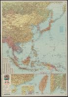
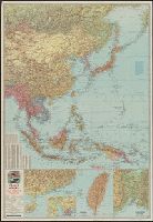
Asie Orientale comprenant L'Empire Chinois et le Japon Les Etats De L'Indo-Chine et le Grand Archi...
Stanford University Libraries
Stanford Libraries SearchWorks

L'Empire de la Chine d'après l'Atlas Chinois avec les Isles du Japon . .
Stanford University Libraries
Stanford Libraries SearchWorks

Mandchourie Corée, Japon et côtes orientales de la chine d'après les documents russes, japonais et...
Bibliothèque nationale de France
Europeana API
Last Updated: 2021-01-30
Uploaded: 2021-07-29