
法廷証第2711A号: 中華民國大地圖及滿洲國圖 [抜粋]
NDL Digital Collections
NDL Digital Collections

信濃國六郡大地震滿水之圖
National Diet Library, Japan
ARC Early Japanese Book Portal Database

滿洲國皇帝陛下御來訪奉祝花電車 滿洲をどり
Tokyo Metropolitan Central Library
Tokyo Metropolitan Library Edo-Tokyo Digital Collections
法廷証第2710A号: 滿洲誌圖 [抜粋]
NDL Digital Collections
NDL Digital Collections
法廷証第238号: 滿洲國ニ於ケル日本國臣民ノ住居及滿洲國ノ課税等ニ關スル日本國滿洲國間條約及附属協定ニ關スル日滿兩國全權委員間了解事項
NDL Digital Collections
NDL Digital Collections
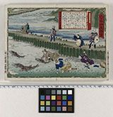
越後國鮭洲走を捕圖
Funabashi-shi Western Library
ADEAC: A System of Digitalization and Exhibition for Archive Collections

大日本國大繪圖
National Diet Library, Japan
ARC Early Japanese Book Portal Database

大和國細見圖
Nara Prefectural Library and Information Center
Mahoroba Digital Library

大和全國地圖
Nara Prefectural Library and Information Center
Mahoroba Digital Library

大日本國全圖
Kyoto University Library
IIIF Discovery in Japan

大日本國全圖
Yoshida-South Library, Kyoto University
IIIF Discovery in Japan

大和國細見圖
National Diet Library, Japan
ARC Early Japanese Book Portal Database

大日本國全圖
National Diet Library, Japan
ARC Early Japanese Book Portal Database
南瞻部洲萬國掌菓之圖
National Diet Library, Japan
ARC Early Japanese Book Portal Database

濠洲大罷工詳報
神戸大学附属図書館
Kobe University Library Digital Archive Newspaper Clippings Collection

滿洲移民の實相 /
Library of Congress
Digital Collections, Library of Congress

新撰縮圖大和全國地圖
Nara Prefectural Library and Information Center
Mahoroba Digital Library

Okuni ezu
Kyushu University Collections
Kyushu University Collections

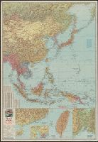
滿洲・支那經濟地理 /
Library of Congress
Digital Collections, Library of Congress

大日本帝國越中國土性圖
Yoshida-South Library, Kyoto University
IIIF Discovery in Japan

大日本國沿海略圖
Kyoto University Library
IIIF Discovery in Japan

大和國信貴山繪圖
Nara Prefectural Library and Information Center
Mahoroba Digital Library
法廷証第3853号: 「大滿洲帝國」: 十週年記念ニ際シテ [抜粋]
NDL Digital Collections
NDL Digital Collections
萬國全圖
Shimane University Library Digital Archive Collection
IIIF Discovery in Japan

The topographic map of Manchoukuo
Stanford University Libraries
Stanford Libraries SearchWorks
![Manshūkoku yochizu [cartographic material] : hyakumanbun no ichi](https://stacks.stanford.edu/image/iiif/dc116hp3130%2Fdc116hp3130_00_0001/full/!200,200/0/default.jpg)
Manshūkoku yochizu [cartographic material] : hyakumanbun no ichi
Stanford University Libraries
Stanford Libraries SearchWorks
War map III featuring the Pacific Theater
Yale University Library
Yale University Library Digital Collections

Chinese Empire (including Trans Oceanic Cables to Hong Kong,etc.)
Stanford University Libraries
Stanford Libraries SearchWorks

Russisch-japanischer Kriegsschauplatz. Karte II, Süd-Mandschurei, Korea, Nordost-China
Stanford University Libraries
Stanford Libraries SearchWorks

Hyakumanbun no ichi Heiyō chiri chōsazu
Stanford University Libraries
Stanford Libraries SearchWorks

Bandai Inawashiro, Japan. (to accompany) Shomitsu Nippon chizu. (Atlas of Japan) Nippon Shoin. (To...
Stanford University Libraries
Stanford Libraries SearchWorks
![Tokyo and vicinity, showing bombed-out areas [cartographic material]](https://stacks.stanford.edu/image/iiif/jx217xm7539%2Fjx217xm7539_00_0001/full/!200,200/0/default.jpg)
Tokyo and vicinity, showing bombed-out areas [cartographic material]
Stanford University Libraries
Stanford Libraries SearchWorks

Asie Orientale comprenant L'Empire Chinois et le Japon Les Etats De L'Indo-Chine et le Grand Archi...
Stanford University Libraries
Stanford Libraries SearchWorks
![Japan and adjacent regions of Asia and the Pacific Ocean [cartographic material] / compiled and drawn in the...](https://collections.library.yale.edu/iiif/2/15510875/full/!200,200/0/default.jpg)
Japan and adjacent regions of Asia and the Pacific Ocean [cartographic material] / compiled and drawn in the...
Yale University Library
Yale University Library Digital Collections

Gojūmanbun no ichi Gobaikaru hōmen sozu
Stanford University Libraries
Stanford Libraries SearchWorks

Oga hanto. Tazawako, Japan. (to accompany) Shomitsu Nippon chizu. (Atlas of Japan) Nippon Shoin. (...
Stanford University Libraries
Stanford Libraries SearchWorks

京都府地形圖
Yoshida-South Library, Kyoto University
IIIF Discovery in Japan

Amazing invasion map : Jap plan to seize the West Coast : Pictorial review. Seattle Post - Intelli...
Stanford University Libraries
Stanford Libraries SearchWorks

Chiba-ken, Japan. (to accompany) Shomitsu Nippon chizu. (Atlas of Japan). Nippon Shoin. (Tokyo, 19...
Stanford University Libraries
Stanford Libraries SearchWorks
![Japan and adjacent regions of Asia and the Pacific Ocean [cartographic material] / compiled and drawn in the...](https://collections.library.yale.edu/iiif/2/15509964/full/!200,200/0/default.jpg)
Japan and adjacent regions of Asia and the Pacific Ocean [cartographic material] / compiled and drawn in the...
Yale University Library
Yale University Library Digital Collections
Last Updated: 2020-04-16
Uploaded: 2021-07-27