
Japan and Korea / compiled and drawn in the Cartographic Section of the National Geographic Society ; James ...
- People
- Time
- Owner Organization
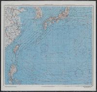
Theater of war in the Pacific Ocean / compiled and drawn in the Cartographic Section of the National Geographic Society for the National Geographic Magazine
National Library of Australia
Trove: National Library of Australia
Japan and adjacent regions of Asia and the Pacific Ocean / compiled and drawn in the Cartographic Section of the National Geographic Society
National Library of Australia
Trove: National Library of Australia
![Japan and adjacent regions of Asia and the Pacific Ocean [cartographic material] / compiled and drawn in the...](https://collections.library.yale.edu/iiif/2/15510875/full/!200,200/0/default.jpg)
Japan and adjacent regions of Asia and the Pacific Ocean [cartographic material] / compiled and drawn in the...
Yale University Library
Yale University Library Digital Collections
![Japan and adjacent regions of Asia and the Pacific Ocean [cartographic material] / compiled and drawn in the...](https://collections.library.yale.edu/iiif/2/15509964/full/!200,200/0/default.jpg)
Japan and adjacent regions of Asia and the Pacific Ocean [cartographic material] / compiled and drawn in the...
Yale University Library
Yale University Library Digital Collections
![China and Japan [cartographic material] / compiled from G.S.G.S. 4065 and 2957](https://collections.library.yale.edu/iiif/2/15510764/full/!200,200/0/default.jpg)
China and Japan [cartographic material] / compiled from G.S.G.S. 4065 and 2957
Yale University Library
Yale University Library Digital Collections
![[Railroads in China, Manchuria, Korea, Japan and the eastern U.S.S.R.] [cartographic material]](https://stacks.stanford.edu/image/iiif/pf710vm7134%2Fpf710vm7134_00_0001/full/!200,200/0/default.jpg)
[Railroads in China, Manchuria, Korea, Japan and the eastern U.S.S.R.] [cartographic material]
Stanford University Libraries
Stanford Libraries SearchWorks
Imperial Genus: The Formation and Limits of the Human in Modern Korea and Japan
Open Access Publishing in European Networks
Europeana API

The parasites of Popillia japonica in Japan and Chosen (Korea), and their introduction into the Un...
United States National Agricultural Library
Europeana API
Innovativeness and development in the economies of Japan, Korea and China. A comparative approach....
Dolnośląska Biblioteka Cyfrowa
Europeana API

Charts, etc
Yale University Library
Yale University Library Digital Collections
![[Taisho Japanese map of the world. Taisho Japanese map of Japan and Korea]. [9 insets].](https://stacks.stanford.edu/image/iiif/yj892bp5625%2F11670000/full/!200,200/0/default.jpg)
[Taisho Japanese map of the world. Taisho Japanese map of Japan and Korea]. [9 insets].
Stanford University Libraries
Stanford Libraries SearchWorks

Farmers of forty centuries; or, Permanent agriculture in China, Korea and Japan. Edited by J.P. Br...
Library of Congress
Europeana API
Farmers of forty centuries; or, Permanent agriculture in China, Korea and Japan. Edited by J.P. Br...
Library of Congress
Europeana API
Map of the Japan Islands : copied from von Siebold's with slight additions & corrections, by the U.S. Japan Expedition and other authorities / Compiled by order of Commodore M.C. Perry, U.S.N. by Lieuts. W.L. Maury and Silas Bent ; James Ackerman, lith. 379 Broady NY
National Library of Australia
Trove: National Library of Australia
Miscellaneous information on Japanese commercial and national activities: The changes in the iron and steel production control structure in Japan. Report No. 53a(34)(d), USSBS Index Section 2
NDL Digital Collections
NDL Digital Collections
The Suma oriental of Tomé Pires : an account of the East from the Red Sea to Japan, written in Malacca and India in 1512-1515; and, The Book of Francisco Rodrigues, rutter of a voyage in the Red Sea, nautical rules, almanack and maps written and drawn in the East before 1515 (Map in pocket of vol.2: The east, from the Red Sea to Japan, as known to Francisco Rodrigques)
National Library of Australia
Trove: National Library of Australia

A new chart of the Pacific Ocean : exhibiting the western coast of America, from Cape Horn to Beerings Strait, the eastern shores of Asia including Japan, China and Australia and all the numerous islands and known dangers situated in Polynesia and Australasia / correctly drawn and regulated according to the most approved and modern surveys and astronomical observations by J.W. Norie
State Library of New South Wales
Trove: National Library of Australia
Reconnoissance of the Gulf and survey of the western shore of the Bay of Yedo / by order of Commodore M.C. Perry U.S.N. by Lieut. W.L. Maury and other officers of the U.S. Japan Expedition in 1853-54 ; drawn by Edw. Sels ; engr. by Selmar Siebert
National Library of Australia
Trove: National Library of Australia
The harbor of Hakodadi, Yesso Id. Japan / surveyed by order of Commodore M.C. Perry U.S.N. by Lieuts. W.L. Maury and G.H. Preble, S. Nicholson & A. Barbot in 1854 ; drawn by Edward Sels ; engraved by S. Siebert
National Library of Australia
Trove: National Library of Australia
Japan and adjacent regions of Asia and the Pacific Ocean [cartographic material] / compiled and drawn in the...
Yale University Library
Yale University Library Digital Collections
Japan and adjacent regions of Asia and the Pacific Ocean [cartographic material] / compiled and drawn in the...
Yale University Library
Yale University Library Digital Collections
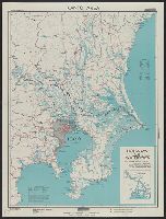
Kantō area : highways and waterways
Yale University Library
Yale University Library Digital Collections
Manshūkoku ryakuzu
National Library of Australia
Trove: National Library of Australia

Nara, Yamada, Koyasan, & environs
Yale University Library
Yale University Library Digital Collections

Russisch-japanischer Kriegsschauplatz. Karte II, Süd-Mandschurei, Korea, Nordost-China
Stanford University Libraries
Stanford Libraries SearchWorks

Rand, McNally & Co.'s 1904 war map of Russia and the continent of Asia
Yale University Library
Yale University Library Digital Collections
![Far East, Japanese occupied area, major railroads [cartographic material] / Board of Economic Warfare, Enemy...](https://collections.library.yale.edu/iiif/2/15510697/full/!200,200/0/default.jpg)
Far East, Japanese occupied area, major railroads [cartographic material] / Board of Economic Warfare, Enemy...
Yale University Library
Yale University Library Digital Collections
![Map of Manchuria, Corea & Japan [cartographic material]](https://collections.library.yale.edu/iiif/2/15828540/full/!200,200/0/default.jpg)
Map of Manchuria, Corea & Japan [cartographic material]
Yale University Library
Yale University Library Digital Collections
AAF cloth chart ; no. C-52, C-53
Yale University Library
Yale University Library Digital Collections

Ise Bay - North :
Yale University Library
Yale University Library Digital Collections

Mandchourie et Coree de Kharbine a Seoul de Port-Arthur a Vladivostok Traduction de la Carte d'Eta...
Stanford University Libraries
Stanford Libraries SearchWorks
Last Updated: 2021-01-30
Uploaded: 2021-07-29