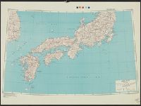
Japan (North) special strategic map / compiled by the Army Map Service
Japan (South) special strategic map / compiled by the Army Map Service
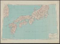
Japan (South) : special strategic map / compiled by the Army Map Service, May 1943
Korea / prepared ... by the Army Map Service, U.S. Army
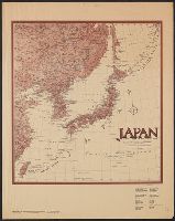
Japan / prepared by the Army Map Service, (GD) Corps of Engineers, U.S. Army
Kurile Islands special strategic map (Sheet The geomagnetic vertical intensity (Z) in CGS-Unit for 1945 and areas of magnetic anomaly.)
Japan (south) special strategic map / prepared under the direction of the Chief of Engineers, U.S. Army, Was...
Australian Army Education Service. map review
Formosa (Taiwan) 1:250,000 / prepared ... by the Army Map Service (cv) U.S. Army

Target Tokyo. Newsmap. Prepared and Distributed by the Army Orientation Course. Special Service Di...
Court Exh. No. 3177: Report of information compiled by the Special Service Organ. For idetification only
East Asia and North Pacific 1:4,350,000 / prepared under the direction of the Chief of Engineers by the Army Map Service (AM) ; U.S. Army, Washington, D.C
Japan and adjacent regions / prepared and distributed by Army Information Branch, Army Service Forces

Railway map of Tokyo & vicinity. U.S. Army Map Service, Far East -58-102 - 10/57.1M.

(Composite Map of) Map of the Island of Japan, Kurile &c. with the Adjacent Coasts of the Chinese ...
Target Tokyo / prepared and distributed by Army Orientation Course, Morale Services Division, Army Service Forces, War Dept
Men of the Special Air Service in the jungle during the Malayan Emergency

Japan. Copyright 1892 by Appleton & Co. (insets) Kurile Islands; Tokyo. (to accompany) The Library...
Caroline Islands 1:25,000 : Yap / prepared under the direction of Engineer, Hq AFFE/BA, by the Military Geology Branch, Intelligence Division ; map compiled by C. G. Johnson, geologist, Military Geology Branch, U.S. Geological Survey, for the Intelligence Division, Office of the Engineer, Hq. U.S. Army Japan

Map of China And the Surrounding Regions. Compiled from the latest information by E. Bretscheider....

Map of the Island of Japan, Kurile &c. with the Adjacent Coasts of the Chinese Dominions and a Ske...

Map of the Island of Japan, Kurile &c. with the Adjacent Coasts of the Chinese Dominions and a Ske...

Japan road map, 1:1,000,000 / prepared under the direction of the Chief of Engineers, U.S. Army by the Army ...
Court Exh. No. 882: Copies of map prepared and issued by the American Army Map Service showing mandated islands of Japan and their situation with respect to other countries
Kurile Islands special strategic map / compiled by the Army Map Service
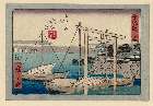
「東海道」 「四十三」「五拾三次之内」「桑名(くわな)」
「諸国名橋奇覧」 「飛越ノ堺 つりはし」
![[下図]「射水郡倉垣組堀岡又新村領附文化十三年放生津潟新開領内検地絵図」文政十二年十月](https://adeac.jp/items/imizu-shinminato-mus/catalog/mp102510-15100/3-1-BII29v2.jpg)
[下図]「射水郡倉垣組堀岡又新村領附文化十三年放生津潟新開領内検地絵図」文政十二年十月

東京名所四十八景 三十七 築地ホテル館

「名所江戸百景」 「深川木場」
諸国名橋奇覧 「飛越野堺つりはし」
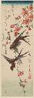
「(連翹(れんぎょう)に燕)」

「畠山二郎重忠」

西伯利十万分一圖オリガ.

「東京名勝圖曾」「上野廣小路」

「(八重桜に小鳥)」
「名所江戸百景」 「深川木場」
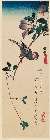
「木蓮に文鳥」
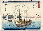
「東都名所」 「御殿山之夕桜」
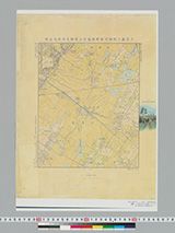
姫嶋村、菱沼村及近傍
「東海道」 「三十一」「五十三次之内」「荒井」

『景勝山梨一覧図』

「生うつし四十八鷹」
「(隷書東海道)東海道」 「十八」「五十三次」「興津(おきつ)」
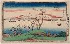
「東都名所」 「佃しま 住吉社」
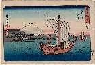
「東都名所」 「駿河町之図」

東京三十六景 二十七 霞かせき
![[教草]](http://www.arc.ritsumei.ac.jp/archive01/theater/th_image/PB/kokkai/rarebook.ndl.go.jp/pre/th_image/gazou/W0000008/w0000111/w0000000/w0000056.jpg)
[教草]
最終更新日: 2020-06-05
登録日: 2021-07-22