Caroline Islands 1:25,000 : Yap / prepared under the direction of Engineer, Hq AFFE/BA, by the Military Geology Branch, Intelligence Division ; map compiled by C. G. Johnson, geologist, Military Geology Branch, U.S. Geological Survey, for the Intelligence Division, Office of the Engineer, Hq. U.S. Army Japan
- Time
- Owner Organization
Central Japan 1:500,000 / prepared under the direction of the Engineer, U.S. Sixth Army, AFPAC, by the 650th Engineer TOP. BN., August 1945
City map, central Tokyo / prepared under the direction of Office of the Engineer, HQ, AFFE, by the 64th Engineer Battalion (Base Topographic)
Japan 1:500,000 / prepared under the direction of the Engineer, U.S. Sixth Army by the 69th EngineerTopo. Co., July 1945 ; reproduced by BMP no 1, GHQ. AFPAC, U.S. Army
Korea / prepared ... by the Army Map Service, U.S. Army
Japan / prepared by the Army Map Service, (GD) Corps of Engineers, U.S. Army
General map of China and adjacent regions, showing treaty ports and railways / prepared for the Department of State, by the Topographic Branch, U.S. Geological Survey

Strategical map of part of Korea and Manchuria / prepared by the Second Division, General Staff (Military In...
Special Report No. 54, Railroads on the Korea - Manchuria Border Eastern Sector" (GHQ, Far East Command, Military Intelligence Section, General Staff, Theater Intelligence Division, Geographic Branch, 20 Jun 1951)
A military display held by the units of the New Zealand Division in New Caledonia during World War II, enemy...
Tokyo city bus routes : June, 1948 / compiled and reproduced by the 64th Engineer Base Topographic Bn
East Asia and North Pacific 1:4,350,000 / prepared under the direction of the Chief of Engineers by the Army Map Service (AM) ; U.S. Army, Washington, D.C

The Japan –US Military Alliance and the Asia-Pacific Challenges: Prospects for Deep Changes

Japan road map, 1:1,000,000 / prepared under the direction of the Chief of Engineers, U.S. Army by the Army ...
A map of South China, scene of the latest military operations by the Japanese. , (Evening Post, 13 October 1...
Brigadier Reginald Miles being invested with the Greek Military Cross by Greek Minister of War
Major General B C Freyberg being invested with the Greek Military Cross by Greek Minister of War
Handbook of instructions for the guidance of the officers of the Elder Scientific Exploration Expedition to the unknown portions of Australia / issued by the Council of the Royal Geographical Society of Australasia, South Australian Branch
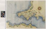
Map of the Japan Islands : copied from von Siebold's with slight additions & corrections, by the U.S. Japan Expedition and other authorities / Compiled by order of Commodore M.C. Perry, U.S.N. by Lieuts. W.L. Maury and Silas Bent ; James Ackerman, lith. 379 Broady NY
Tsunamis in the Pacific Basin, 1900-1983 / map produced by Patricia A. Lockridge, National Geophysical Data Center and Ronald H. Smith, Cooperative Institute for Research in Environmental Sciences ; published by National Geophysical Data Center and World Data Center A for Solid Earth Geophysics with support from Office of U.S. Foreign Disaster Assistance, Agency for International Development in cooperation with Circum-Pacific Council for Energy and Mineral Resources, Map Project

城田村下板字南三本松全図

染井村中佐野村絵図

A Turner and His Assistant
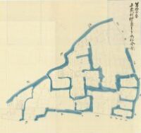
狭山池惣絵図 享保7年(1722)

大久保

犬井道村字久五左エ門搦全図
.jpg)
Asamagadakeomokagezoushi、tomoenojou kataokagatou

飯盛村字三本栁全図

「伝兵へ 小川吉太郎」「女さる廻し小よし 中村三光」

徳島舊士族禄高付図
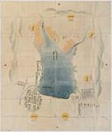
房相海岸炮台図
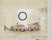
高松旧藩飛竜丸明細切絵図
城田村柳島字三本松全図

児島海面境御許裁之絵図

畑田

古賀・正手

古賀・正手

東松浦郡町村図(乙)見借村

Shimizu, from the series "Fifty Kyogen Plays (Kyogen gojuban)"

「葛飾廿四将」 「九郎判官義経」

東松浦郡町村図(乙)湯野浦村

「清水」
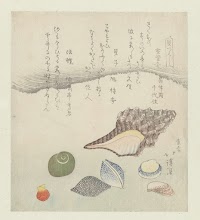
Reflectieschelp, ivoorschelp en tritonschelp
Last Updated: 2020-06-05
Uploaded: 2021-07-22