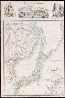
Map of the Island of Japan, Kurile &c. with the Adjacent Coasts of the Chinese Dominions and a Ske...
- People
- Time
- Owner Organization

Map of the Island of Japan, Kurile &c. with the Adjacent Coasts of the Chinese Dominions and a Ske...
Stanford University Libraries
Stanford Libraries SearchWorks

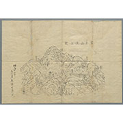
(Lower Sheet to) Map of the Island of Japan, Kurile &c. with the Adjacent Coasts of the Chinese Do...
Stanford University Libraries
Stanford Libraries SearchWorks
Stanford's map of China & Japan with the adjacent parts of the Russian Repubcs. India, Burma &c / Stanford's Geographical Establishment
National Library of Australia
Trove: National Library of Australia

A Map of the East-Indies and the Adjacent Countries; with the Settlements, Factories and Territori...
Stanford University Libraries
Stanford Libraries SearchWorks

A Map of the East-Indies and the Adjacent Countries; with the Settlements, Factories and Territori...
Stanford University Libraries
Stanford Libraries SearchWorks

A Map of the East-Indies and the Adjacent Countries; with the Settlements, Factories and Territori...
Stanford University Libraries
Stanford Libraries SearchWorks

A Map of the East-Indies and the Adjacent Countries; with the Settlements, Factories and Territori...
Stanford University Libraries
Stanford Libraries SearchWorks

Japan, Mandshuria (Showing The Course of the Amur River) The Kurile Isles &c. Accroding to the Bri...
Stanford University Libraries
Stanford Libraries SearchWorks

Japan, Mandshuria (Showing The Course of the Amur River) The Kurile Isles &c. Accroding to the Bri...
Stanford University Libraries
Stanford Libraries SearchWorks
Kurile Islands special strategic map / compiled by the Army Map Service
National Library of Australia
Trove: National Library of Australia
![[Chinese Text with Image of a Map of the World]](https://api.europeana.eu/api/v2/thumbnail-by-url.json?uri=http%3A%2F%2Fmedia.iwm.org.uk%2Fiwm%2FmediaLib%2F191%2Fmedia-191923%2Flarge.jpg&type=IMAGE)
[Chinese Text with Image of a Map of the World]
Imperial War Museum
Europeana API
![Kyūshū no zu [Map of Kyūshū Island, Japan]](https://collections.library.yale.edu/iiif/2/15511841/full/!200,200/0/default.jpg)
Kyūshū no zu [Map of Kyūshū Island, Japan]
Yale University Library
Yale University Library Digital Collections
![Kyūshū no zu [Map of Kyūshū Island, Japan]](https://collections.library.yale.edu/iiif/2/15511837/full/!200,200/0/default.jpg)
Kyūshū no zu [Map of Kyūshū Island, Japan]
Yale University Library
Yale University Library Digital Collections

The railway map of Japan
Boston Public Library
DPLA API

Map of the Empire of Japan
Salem State University Archives and Special Collections
DPLA API

A map of the city of Nagasaki, and of the adjacent country; Sorts of money current in the Japanese Empire
General Research Division. The New York Public Library
DPLA API
Islands of Japan
Yale University Library
Yale University Library Digital Collections
Map of the Japanese Archipelago
Honolulu Museum of Art
Honolulu Museum of Art Collection

Map of Japanese Homeland Island
Philadelphia Museum of Art
Philadelphia Museum of Art collection

A chart of the tradeing part of the East Indies and China, with the adjacent islands, from Surrat ...
Royal Museums Greenwich
Europeana API

Charts, etc
Yale University Library
Yale University Library Digital Collections

Map of the Empire of Japan in 1914
New Zealand Ministry for Culture and Heritage
DigitalNZ New Zealand API

Chinese and Japanese ports. (with) The mainland of Japan with the islands of Kiushiu & Shikoku. Ge...
Stanford University Libraries
Stanford Libraries SearchWorks

A map of the Empire of Japan, made by Dr. Kaempfer [with maps of Kamchatka, Northern coast of Japan, as well...
General Research Division. The New York Public Library
DPLA API
(Lower Sheet to) Map of the Island of Japan, Kurile &c. with the Adjacent Coasts of the Chinese Do...
Stanford University Libraries
Stanford Libraries SearchWorks
Pas-caert van't Oostelyckste deel van Oost Indien : met alle de Eylanden daer onder gelegen, van Cabo Comorin tot aen Japan / by Hendrick Doncker Boekverkooper en Graadbooghmaacker Inde Nieuwbrughsteegh
National Library of Australia
Trove: National Library of Australia
Charts, etc
Yale University Library
Yale University Library Digital Collections
「十二月」
Tokyo National Museum
ARC Ukiyo-e Portal Database

Auckland Harbour
Stanford University Libraries
Stanford Libraries SearchWorks

「〔箱根絵図〕」
Tokyo Metropolitan Central Library
ARC Ukiyo-e Portal Database

Carte Des Indes Orientales dessinee suivant les Observations les plus recentes dont le principal e...
Stanford University Libraries
Stanford Libraries SearchWorks
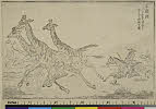
「之猟☆」 「「バッケル」氏大湖地方ニ於テ之ヲ狩猟セル図」
C. V. Starr East Asian Library, University of California, Berkeley
ARC Ukiyo-e Portal Database

女・梅下・伊勢
Tokyo National Museum
ARC Ukiyo-e Portal Database

Hyakumanbun no ichi Nanpō kōkūzu
Stanford University Libraries
Stanford Libraries SearchWorks

「大仏耳塚」
C. V. Starr East Asian Library, University of California, Berkeley
ARC Ukiyo-e Portal Database

「安房国鋸山日本寺図」
Tokyo Metropolitan Central Library
ARC Ukiyo-e Portal Database

冨士山東口須走(登山案内図)
Mt.Fuji World Heritage Center, Shizuoka
ADEAC: A System of Digitalization and Exhibition for Archive Collections
Carte générale de l'empire Chinois et du Japon / par A. H. Brué, géographe de S.A.R. Monsieur ; gravée sous la direction de l'auteur
National Library of Australia
Trove: National Library of Australia
富士山頂上図(表口、須山口)
Mt.Fuji World Heritage Center, Shizuoka
ADEAC: A System of Digitalization and Exhibition for Archive Collections
七草祝
Tokyo National Museum
ARC Ukiyo-e Portal Database
Last Updated: 2020-04-17
Uploaded: 2021-09-21