
(Composite Map of) Map of the Island of Japan, Kurile &c. with the Adjacent Coasts of the Chinese ...
- People
- Time
- Owner Organization

(Upper Sheet to) Map of the Island of Japan, Kurile &c. with the Adjacent Coasts of the Chinese Do...

(Lower Sheet to) Map of the Island of Japan, Kurile &c. with the Adjacent Coasts of the Chinese Do...
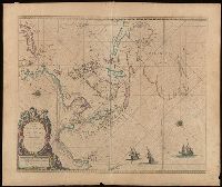
Map of the Island of Japan, Kurile &c. with the Adjacent Coasts of the Chinese Dominions and a Ske...

Map of the Island of Japan, Kurile &c. with the Adjacent Coasts of the Chinese Dominions and a Ske...
Stanford's map of the empires of China and Japan : with the adjacent parts of the Russian Empire, ...
Stanford's map of the empires of China and Japan with the adjacent parts of the Russian Empire, India, Burma &c / Stanford's Geogl. Estabt
Stanford's map of China & Japan with the adjacent parts of the Russian Repubcs. India, Burma &c / Stanford's Geographical Establishment

A Map of the East-Indies and the Adjacent Countries; with the Settlements, Factories and Territori...

A Map of the East-Indies and the Adjacent Countries; with the Settlements, Factories and Territori...

A Map of the East-Indies and the Adjacent Countries; with the Settlements, Factories and Territori...

A Map of the East-Indies and the Adjacent Countries; with the Settlements, Factories and Territori...

A Map of the East-Indies and the Adjacent Countries; with the Settlements, Factories and Territori...

A Map of the East-Indies and the Adjacent Countries; with the Settlements, Factories and Territori...

Advanced composite materials : the official journal of the Japan Society of Composite Materials

Map of Asia
![[Chinese Text with Image of a Map of the World]](https://api.europeana.eu/api/v2/thumbnail-by-url.json?uri=http%3A%2F%2Fmedia.iwm.org.uk%2Fiwm%2FmediaLib%2F191%2Fmedia-191923%2Flarge.jpg&type=IMAGE)
[Chinese Text with Image of a Map of the World]
Kurile Islands special strategic map / compiled by the Army Map Service

A map of the city of Nagasaki, and of the adjacent country; Sorts of money current in the Japanese Empire

Map of the Empire of Japan
Reconnaissance map of Brunei & adjacent territories, 1937 : Burunai
![Kyūshū no zu [Map of Kyūshū Island, Japan]](https://collections.library.yale.edu/iiif/2/15511841/full/!200,200/0/default.jpg)
Kyūshū no zu [Map of Kyūshū Island, Japan]
![Kyūshū no zu [Map of Kyūshū Island, Japan]](https://collections.library.yale.edu/iiif/2/15511837/full/!200,200/0/default.jpg)
Kyūshū no zu [Map of Kyūshū Island, Japan]

Karta Aziatskoi Rossii . . . [Map of the Asian part of Russia and Possessions Adjacent, with the R...

Islands of Japan. (with) Japan, Mandshuria, (Showing the Course of the Amur River) The Kurile Isle...

Carte Des Indes et de la Chine Dressee sur plusieurs Relations particulieres Rectifees par quelque...

Hyakumanbun no ichi Nanpō kōkūzu

Carte Des Indes et de la Chine Dressee sur plusieurs Relations particulieres Rectifees par quelque...
A new map of India & China from the latest observations / by I. Senex
A new map of the empires, states, provinces &c of Asia : including also the Turkish & Russian dominions in Europe & New Holland / compiled from the most authentic observations by Robert Wilkinson ; Walsh script. ; W. Palmer sculpt
Empire of Japan / published under the superintendence of the Society for the Diffusion of Useful Knowledge
Paskaerte zynde t'Oosterdeel van Oost Indien : met alle de Eylanden daer ontrendt geleegen van C. Comorin to...

A Chart of the Eastermost part of the East Indies and China from Cape Comarin to Japan with the Ad...

Karte von Australien oder Polynesien, nach den Zeichnungen, Reisebe Schreibungen und Tagebucher de...

武相駿豆名所一覧図

Shintei shiku kaisei Tōkyō meisai zenzu

China, Contains 15 Subject Provinces, including the 2 Islands of Hainan Formosa and the Tributary ...

Empire of Japan. (with) Nagasaki Harbour. Engraved by J. & C. Walker. Published under the superint...
Japanse schildering van huis in sneeuwlandschap

Tatariae Sinensis Mappa Geographica ex Tabulis secialibus R.R.P.P. Iesuitarum nec non Relationibus...

Imperii Sinarum Nova Descriptio
Japanse schildering met diverse eenden
L'empire de la Chine : d'après l'atlas Chinois, avec les isles du Japon / par M. Bonne, Membre de la Societʹe Litteraire Militre. Ingenieur Gʹeographe &c
Pacific Ocean [by Sidney E. Morse]

Kuniyoshi's preparatory drawings, no.48

L'Empire Du Japon devisé en sept principales parties, et subdivisè en soixante et six Royaumes, Par le Sr....
![Indo Hyakumanbunnoichi Zu Tōbu Shūiki [cartographic material]](https://stacks.stanford.edu/image/iiif/wr290sd1084%2Fwr290sd1084_00_0001/full/!200,200/0/default.jpg)
Indo Hyakumanbunnoichi Zu Tōbu Shūiki [cartographic material]

東亞大陸圖 : 二百五十万分一

China divided into its great provinces and the Isles of Japan by Samuel Dunn
Last Updated: 2020-04-17
Uploaded: 2021-09-21