
Japan, the target : a pictorial Jap-map : By Ernest Dudley Chase of Winchester, Mass. Published an...

Japan, The Target - A Pictorial Jap-Map. By Ernest Dudley Chase. Winchester, MA. Published and cop...

A pictorial map : Victory in the Pacific Designed and published by Ernest Dudley Chase of Winchest...

Japan, the target a pictorial Jap-map

Amazing invasion map : Jap plan to seize the West Coast : Pictorial review. Seattle Post - Intelli...

New map of Shanghai. (on verso) A map of China : Published by K. Saito. Osaka Japan Sole agent T. ...

A map of China : Published by K. Saito. Osaka Japan. Sole agent T. Kishida & Co. Shanghai. (inset ...

The New War Map of Maryland Part of Virginia & Pennsylvania. Published by B.B. Russell . .

Map of Japan. Published by George F. Cram, Chicago, Ill. (to accompany) Cram's atlas of the world,...
A map of China : Published by K. Saito. Osaka Japan. Sole agent T. Kishida & Co Shanghai. (inset m...

An Improved Map of the United States By Shelton & Kensett

Japan. London, Published Jany. 4.1825 by A. & S. Arrowsmith, No.10 Soho Square
Quadruple threat to Japan / News map by staff artist Sundberg

Japan. Re- Published, Jany st. 1845, by G.F. Cruchley, Mapseller, 81 Fleet Street, London. (to acc...

Japan & Corea. The Illustrations by H. Warren & Engraved by J.H Kernot. The Map Drawn & Engraved b...

Japan & Corea. The Illustrations by H. Warren & Engraved by J.H Kernot. The Map Drawn & Engraved b...

Topographical map of the Japanese Empire, 1899 / Imperial Geological Survey of Japan ; drawn by T. Togawa an...

Stanford's library Map of Japan / principally compiled from japanese documents, by E. Knipping
China and Japan with adjoining countries / compiled and published by H.E.C.Robinson Pty. Ltd

Sharpe's Corresponding Maps. South Eastern Asia. Birmah - China - Japan London - Published by Chap...

Manchoutikuo and adjoining territories. Published by the Land Survey Department, Japan, 1935

map from "Advance Japan: a nation thoroughly in earnest. ... Illustrations by R. Isayama"
Japan / prepared by the Army Map Service, (GD) Corps of Engineers, U.S. Army

Rand, McNally & Company's indexed atlas of the world map of Japan Copyright 1892, by Rand, McNally...

Facsimile of the official map made by Abel Janszoon Tasman's expedition to Japan in 1639
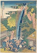
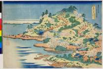
「諸国滝廻リ」 「相州大山ろうべんの滝」
諸國瀧廻リ 相州大山ろうべんの瀧

Roben Falls at Oyama in Sagami Province (Soshu Oyama Roben no taki), from the series "A Tour of Waterfalls in Various Provinces (Shokoku taki meguri)"

Dated Events. On To Tokyo. Map of the Pacific and the Far East. Stanley Turner, 44. Copyright, Can...
Dated Events. On To Tokyo. Map of the Pacific and the Far East. Stanley Turner, 44 Copyright, Cana...

Dated Events. On To Tokyo. Map of the Pacific and the Far East. Stanley Turner, 44. Copyright, Can...

「諸国滝廻リ」 「相州大山 ろうべんの滝」
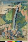
「諸国滝廻リ」 「相州大山ろうべんの滝」
「諸国滝廻リ」 「相州大山ろうべんの滝」
諸國瀧廻リ 相州大山ろうべんの瀧

いがうへの案内
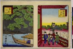
「東京名所」「金竜山浅草寺」「首尾の松」

South China Sea. South East Asia - Selected Areas. Pergamon World Atlas. Pergamon Press, Ltd. & P....

New Map of Japan

Sitaya hirokōji

「今様忠臣蔵三段目」

「春の寿」

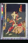
「無官太夫敦盛 中村福助」
「諸国名橋奇覧」 「摂州阿治川口天保山」

「今昔児手柏 八」 「藤屋伊左衛門」「吉田屋喜左衛門」

「春色三十六会席」 「平松町 魚仙」「植木店ひさ吉」「うゑき店才蔵」
「明治座新狂言朝比奈門破り組上ケ三枚續」

「仮名手本忠臣蔵」 「大序」
「豊国漫画図絵」 「弁天小僧菊之介」
最終更新日: 2020-04-17
登録日: 2021-09-21