
Series (Standard map series designation system) ; 5205
- People
- Time
- Owner Organization
China and Japan with adjoining countries / compiled and published by H.E.C.Robinson Pty. Ltd
Court Exh. No. 3155: Map of Hailar Sappa area prepared in 1932 by the Japanese Land Survey Department
Court Exh. No. 3155: Map of Hailar Sappa area prepared in 1932 by the Japanese Land Survey Department
General map of China and adjacent regions, showing treaty ports and railways / prepared for the Department of State, by the Topographic Branch, U.S. Geological Survey
Hokkaido, Japan : Special airfield relief map / prepared and reproduced in the United States Department of the Interior Geological Survey
Relief map of southern Japan / prepared and reproduced in the United States Department of the Interior Geological Survey
Hokkaido, Japan / prepared and reproduced in the United States Department of the Interior, Geological Survey
Relief map of Southern Japan : special airfield relief map / prepared and reproduced in the United States Department of the Interior Geological Survey
Court Exh. No. 2713: Map published by the Department of Ministry Topographer of the Workers and Peasants Red Army relating to the years of 1933 and 1935
Relief map of Northern Honshu / prepared and reproduced in the United States Department of the Interior Geological Survey
Relief map of Northern Honshu : special airfield relief map / prepared and reproduced in the United States Department of the Interior Geological Survey
Court Exh. No. 2713: Map published by the Department of Ministry Topographer of the Workers and Peasants Red Army relating to the years of 1933 and 1935. For idetification only

New railway map of Tokyo and vicinity. Published by Japan Guide Map Co., Ltd. Compiled and printed...

Topographical map of the Japanese Empire, 1899 / Imperial Geological Survey of Japan ; drawn by T. Togawa an...

Map of Japan. Published by George F. Cram, Chicago, Ill. (to accompany) Cram's atlas of the world,...

A pictorial map : Victory in the Pacific Designed and published by Ernest Dudley Chase of Winchest...
Map of Japan and Manchoukuo : issued with the Japan year book, 1938-39 / by T. Sasaki, Y. Nogi
A map of the East-Indies and adjacent countries : with settlements, factories, and territories : explaining what belongs to England, Spain, France, Holland, Denmark, Portugal, etc. with many remarks not extant in any other map / by H. Moll, geog
A map of the East-Indies and adjacent countries : with settlements, factories, and territories : explaining what belongs to England, Spain, France, Holland, Denmark, Portugal, etc. with many remarks not extant in any other map / by H. Moll, geog
Reconnoissance of the Gulf and survey of the western shore of the Bay of Yedo / by order of Commodore M.C. Perry U.S.N. by Lieut. W.L. Maury and other officers of the U.S. Japan Expedition in 1853-54 ; drawn by Edw. Sels ; engr. by Selmar Siebert
Caroline Islands 1:25,000 : Yap / prepared under the direction of Engineer, Hq AFFE/BA, by the Military Geology Branch, Intelligence Division ; map compiled by C. G. Johnson, geologist, Military Geology Branch, U.S. Geological Survey, for the Intelligence Division, Office of the Engineer, Hq. U.S. Army Japan
Tsunamis in the Pacific Basin, 1900-1983 / map produced by Patricia A. Lockridge, National Geophysical Data Center and Ronald H. Smith, Cooperative Institute for Research in Environmental Sciences ; published by National Geophysical Data Center and World Data Center A for Solid Earth Geophysics with support from Office of U.S. Foreign Disaster Assistance, Agency for International Development in cooperation with Circum-Pacific Council for Energy and Mineral Resources, Map Project

Konan chiho jikyoku shsaizu. (inset) Shanhai, Nankin Fukin. (on verso) Hitome de wakaru shina jihe...

Hyakumanbun no ichi Heiyō chiri chōsazu
![Shisen fukin gojūmanbun no ichi chishizu [cartographic material] : heiyō chishizu](https://stacks.stanford.edu/image/iiif/nn836py9296%2Fnn836py9296_00_0001/full/!200,200/0/default.jpg)
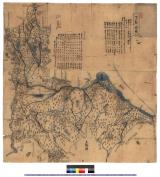
Shisen fukin gojūmanbun no ichi chishizu [cartographic material] : heiyō chishizu

Gojūmanbun no ichi Gobaikaru hōmen sozu
備中国大絵図 : 備中国図
Manchoutikuo and adjoining territories

Chinesisches Reich
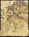
楼閣山水図屏風

Jūmanbun no ichizu Kokuka oyobi Buragōweshichensuku

Europa im Zeitalter Napoleons, 1789 bis 1815
Accuratissima totius Asiae tabularecens emendata / per Fredericum de Witt Amstelodami ; F. de Wit excudit

尾濃御領分御代官所支配分図 : 尾張御領分御代官所支配分図
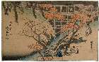
Kyoutomeishonouchi

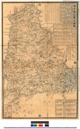
徳島県全図
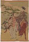
「見立業平東下り」
長篠合戦図屏風
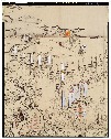
下総国図 : 下総国図

Map of the Empire of China and Japan. J.W. del. (engraved by) Stockley, Sc London, James Wyld, Cha...
Manshūkoku ryakuzu

徳島市街全図

Nara, Yamada, Koyasan, & environs

Carte générale de la Tartarie Chinoise dressée sur les cartes particulières faites sur les lieux p...

Asia
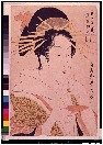
「郭中美人競」 「扇屋瀧川」
Last Updated: 2021-01-30
Uploaded: 2021-07-29