Dated Events. On To Tokyo. Map of the Pacific and the Far East. Stanley Turner, 44 Copyright, Cana...
- People
- Time
- Owner Organization

Dated Events. On To Tokyo. Map of the Pacific and the Far East. Stanley Turner, 44. Copyright, Can...

Dated Events. On To Tokyo. Map of the Pacific and the Far East. Stanley Turner, 44. Copyright, Can...
Hagstrom's map of the Pacific and the Far East : on Mercator's projection

Rand McNally map of Eastern Asia and Western Pacific Ocean. (Mercator projection). Copyright by Ra...

Rand McNally map of Eastern Asia and Western Pacific Ocean. Mercator projection. Copyright by Rand...

Map of the Pacific Ocean
![[World War II battlefronts]. Map VI. The Southwest Pacific. Copyright, 1944, by Remington Rand, In...](https://stacks.stanford.edu/image/iiif/vs321mz7073%2F6758006/full/!200,200/0/default.jpg)
[World War II battlefronts]. Map VI. The Southwest Pacific. Copyright, 1944, by Remington Rand, In...
Ampol Pacific map / with the compliments of Australian Motorists Petrol Co. Ltd. ; published Gregory Publishing Co. ; copyright C. Barrass
Map of the Pacific theatre, 1941-1945
The war against Japan (Japanese & Pacific Map)
Japan's Future in East Asia and the Pacific
Japan's Future in East Asia and the Pacific
Span of the U.S. in the Pacific / news map by staff artist Sundberg
East Asia and North Pacific 1:4,350,000 / prepared under the direction of the Chief of Engineers by the Army Map Service (AM) ; U.S. Army, Washington, D.C
This map of the South-ivest Pacific combat zone shows how United Nations offensives are preparing the ' way ...
This map of the Pacific shows the "pincers" strength of the United States from the Aleutian Islands in the n...

A pictorial map : Victory in the Pacific Designed and published by Ernest Dudley Chase of Winchest...
.jpg)
This map indicates the tactical position in the Pacific in August 1942 when the Allied counter offensive was...
Pearl adds Russia's Far East, sets trip to S. Pacific for veterans. (Pearl Cruises; includes related article on travel to Guadalcanal) (Travel Weekly's Cruise Guide)
Pacific war map / Dept. of Home Security ; issued by authority of the Minister for Home Security with the permission of Associated Newspapers Ltd
Tsunamis in the Pacific Basin, 1900-1983 / map produced by Patricia A. Lockridge, National Geophysical Data Center and Ronald H. Smith, Cooperative Institute for Research in Environmental Sciences ; published by National Geophysical Data Center and World Data Center A for Solid Earth Geophysics with support from Office of U.S. Foreign Disaster Assistance, Agency for International Development in cooperation with Circum-Pacific Council for Energy and Mineral Resources, Map Project
Dated Events. On To Tokyo. Map of the Pacific and the Far East. Stanley Turner, 44 Copyright, Cana...
Dated Events. On To Tokyo. Map of the Pacific and the Far East. Stanley Turner, 44. Copyright, Can...

Umegae (Object); Buyu nazorae Genji (Series)

Japan, the target : a pictorial Jap-map : By Ernest Dudley Chase of Winchester, Mass. Published an...
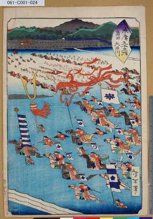
「末廣五十三次」「島田 大井川」

Tookaidoo gojuusan tsugi no uchi Mariko

Okinawa Mem-O-Map part of the Ryukyu Islands. Drawn by T/4 John G. Drury 214th_ Ordnance Battalion...

South China Sea. South East Asia - Selected Areas. Pergamon World Atlas. Pergamon Press, Ltd. & P....
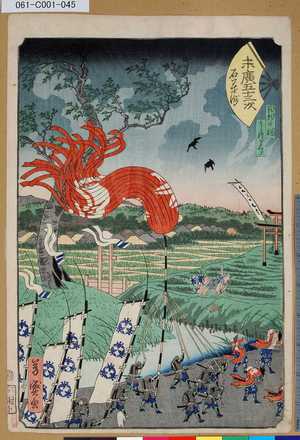
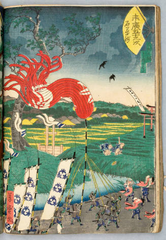
「末廣五十三次」「石藥師」 「範頼の祠」「よし経ざくら」
Toukyoumeisho、kyuuryuuzansensouji、shubinomatsu

No. 39. Asiatische Inselwelt

New Map of Japan

「東都三十六景」

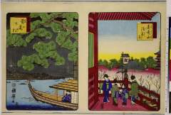
Edo Meisho

Shokokumeishohyakkeienshuu akibagongen fukuroidako
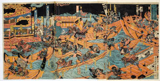
The Battle of Dan-no-ura in Yashima, Nagato Province in the First Year of the Bunji Era

Jam packed Nipponese Islands offer rare target for United Nations' bombing squadrons. Japan. Copyr...
Ishiyakushi, series Tōkaidō Album by various artists

(Hokkaido 1). (to accompany) Shomitsu Nippon chizu. (Atlas of Japan). Nippon Shoin (Tokyo, 1956)

Sakata Kaidomaru

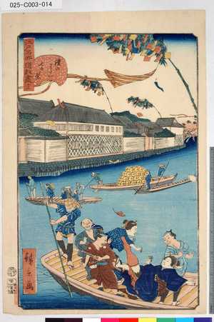
東海道名所之内 伊勢外宮

「江戸自慢三十六興」 「今戸 焼物」
「江戸名所道戯盡」 「十三」「鎧のわたし七夕祭」

Kites of Fukuroi and Distant View of Akiba in Totomi Province (Enshu Akiba enkei Fukuroi tako), from the series "One Hundred Famous Views in the Various Provinces (Shokoku meisho hyakkei)"
Last Updated: 2020-04-17
Uploaded: 2021-09-21