
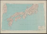
Stanford's library Map of Japan / principally compiled from japanese documents, by E. Knipping
- Time
- Owner Organization

Lloyd's Official Map of the State of Tennessee Compiled From Actual Sureys and Official Documents ...

Map of China And the Surrounding Regions. Compiled from the latest information by E. Bretscheider....
Japan (North) :
Japan (North) special strategic map / compiled by the Army Map Service
Stanford's map of China & Japan with the adjacent parts of the Russian Repubcs. India, Burma &c / Stanford's Geographical Establishment
Japan (South) special strategic map / compiled by the Army Map Service
Tectonic map of Japan / compiled by Hiroshi Isomi in 1965

New railway map of Tokyo and vicinity. Published by Japan Guide Map Co., Ltd. Compiled and printed...
Stanford's map of the empires of China and Japan with the adjacent parts of the Russian Empire, India, Burma &c / Stanford's Geogl. Estabt
Stanford's map of the empires of China and Japan : with the adjacent parts of the Russian Empire, ...

Map of Colorado Territory, Compiled from Government Maps & Actual Surveys. Made In 1861

Map of Colorado Territory, Compiled from Government Maps & Actual Surveys. Made In 1861

Map of Colorado Territory, Compiled from Government Maps & Actual Surveys. Made In 1861

Map of Colorado Territory, Compiled from Government Maps & Actual Surveys. Made In 1861

Stanford's map of China and Japan with the adjacents parts of the Russian Rebubcs., India, Burma &...
Stanford's map of eastern China, Japan and Korea : the seat of war in 1894
![[Taisho Japanese map of the world. Taisho Japanese map of Japan and Korea]. [9 insets].](https://stacks.stanford.edu/image/iiif/yj892bp5625%2F11670000/full/!200,200/0/default.jpg)
[Taisho Japanese map of the world. Taisho Japanese map of Japan and Korea]. [9 insets].
Seinan Taiheiyo seizu [Map of southwest Pacific Ocean] / compiled by Asahi Shinbunsha

Japan : South coast of Honshu : Gulf of Tokyo or Yedo. Compiled from Japanese Government, and Brit...
Map of Japan / by the Welcome Society ; engraved by H. Kobayashi
List of Books Brought from China, compiled by Kōbō Daishi (Shōrai Mokuroku)
Japan opened compiled chiefly from the narrative of the American expedition to Japan, in the years...
Nippon (Japan) 1876 : compiled from native maps and the notes of recent travellers / by R. Henry Brunton

Topographical map of the Japanese Empire, 1899 / Imperial Geological Survey of Japan ; drawn by T. Togawa an...

Greece in the fifth century B.C

Karte vom Japanischen Reiche nach Originalkarten und astronomischen Beobachtungen der Japaner. : D...

The Islands of Japan, by James Wyld,..

Japan from "Japan in Transition. A comparative study of the progress, policy, and methods of the J...

Karte von einem Theil der Nordwestlichen Küste von America; zu der Reise des Capit. George Vancouv...

日本内海大阪及神戸 = Japan Naikai, Ōsaka and Kōbe
A new & correct chart of the Indian Sea from Cabo Bonea Esperanca to Japan according to Mr. Edward Wrights projection vulgarly called Mercators chart

map from "Corea, the hermit nation. I. Ancient and mediæval history. II. Political and social Core...

L'Impero Del Giapon diviso in sette principali pari Cioe Ochio Quanto Jetsegen Jetsen Jamaisoit, X...
![安房国[東海道図]](https://rmda.kulib.kyoto-u.ac.jp/iiif/RB00020023/RB00020023_00001_0.ptif/full/200,/0/default.jpg)
安房国[東海道図]

大日本国海陸精図 : 大日本国海陸精図

名護屋古城之図

亜細亜東部略図
![尾張国[東海道図]](https://rmda.kulib.kyoto-u.ac.jp/iiif/RB00020015/RB00020015_00001_0.ptif/full/200,/0/default.jpg)
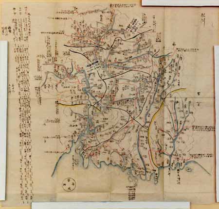
尾張国[東海道図]

佐賀県管内図

日本本州北西岸丹後宮津湾及近海 = Japan Honshū, north west coast Miyadsu bay and approaches

実測安房全図

都市計畫基本圖. : 5 鷹ヶ峯
Tajimanokunizu
City plan of Yokohama

Igakoenorikakegappa
![上総国[東海道図]](https://rmda.kulib.kyoto-u.ac.jp/iiif/RB00020024/RB00020024_00001_0.ptif/full/200,/0/default.jpg)
上総国[東海道図]

佐賀県管内全図

日本四国南岸土佐浦戸港高知=Japan Shikoku, south coast, Urado Harbour and Kōchi
Last Updated:
Uploaded: 2021-07-27