![Kantō area [cartographic material] : highways and waterways](https://stacks.stanford.edu/image/iiif/gd204cf5107%2Fgd204cf5107_00_0001/full/!200,200/0/default.jpg)
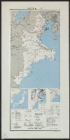
Kantō area [cartographic material] : highways and waterways

Japan series: Tokyo highways
Highways and byeways in Japan
![Tokyo [cartographic material] : [showing rail, subway and tram lines of the metropolitan area].](https://stacks.stanford.edu/image/iiif/ys971pn1490%2Fys971pn1490_0001/full/!200,200/0/default.jpg)
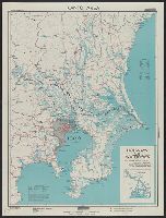
Tokyo [cartographic material] : [showing rail, subway and tram lines of the metropolitan area].
Report on Chinese rolling stock, 7 March 1944. (182) Report on Chinese waterways and highways, 10 March 1944. Report No. 19-b(181), USSBS Index Section 6

Picture of Steam Locomotive and Waiting Area at Tokyo Shiodome Station
Soldiers and gun, Pacific area, during World War II
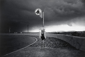
Highway Telephone and Lightning, New Mexico

Japan and Russia Will Divide China. Signs Increase That Northern Area and Lower Yangtze Basin Will...
![Far East, Japanese occupied area, major railroads [cartographic material]](https://stacks.stanford.edu/image/iiif/zm881nj6799%2Fzm881nj6799_00_0001/full/!200,200/0/default.jpg)
Far East, Japanese occupied area, major railroads [cartographic material]
Map showing the area affected in the present differences betiveen Russia and Japan, (Evening Post, 05 August...

Osaka-Kobe area: Amagasaki: Hyogo and Osaka Prefectures, Honshu, Japan
F G Smith and T Turner sweeping road edge for hidden mines in Belmonte area, Italy, World War II - Photograp...
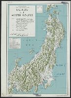
Central Japan (central and northern Honshu) : roads and water routes
Kaye, George, 1914- : NZ soldier and tank, Senio River area, Italy
Euro area economic trends 2006 and 2007: gambling with the recovery

The Pacific - Vital area for United States and Japan. Los Angels Examiner ... November 1942. Howar...
Japanese prisoners of war at work on the roads in the Wairarapa area
Japanese prisoners of war at work on the roads in the Wairarapa area

Osaka-Kobe area: Osaka Harbor and Osaka South: Osaka Prefecture, Honshu, Japan
Prime Minister Peter Fraser and Lieutenant General Edward Puttick walk through poppy field in Cassino area, ...

Gas and water-supply in greater Tokyo - 1928
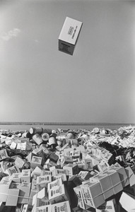
Empty Box in its Way Down to a Reclamation Area, Tokyo
Euro area economic trends 2006 and 2007: the upswing - will it last
![Far East, Japanese occupied area, major railroads [cartographic material] / Board of Economic Warfare, Enemy...](https://collections.library.yale.edu/iiif/2/15510697/full/!200,200/0/default.jpg)
Far East, Japanese occupied area, major railroads [cartographic material] / Board of Economic Warfare, Enemy...

Japan, Yamaguchi-ken
![Japan and adjacent regions of Asia and the Pacific Ocean [cartographic material] / compiled and drawn in the...](https://collections.library.yale.edu/iiif/2/15510875/full/!200,200/0/default.jpg)
Japan and adjacent regions of Asia and the Pacific Ocean [cartographic material] / compiled and drawn in the...

Japan and Korea / compiled and drawn in the Cartographic Section of the National Geographic Society ; James ...
Japan, Mie-ken
Japan, Miyazaki-ken
Japan, Aichi-ken

Japan, Honshu - South Coast : Iseno Umi or Ise Wan and Mikawa Wan with approaches, from Japanese surveys to ...

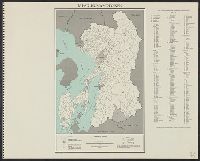
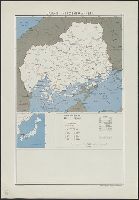
Japan. Miyagi-ken : administrative divisions, November 1943 / lithographed in G.P.O.: Department of State Se...
Japan, Wakayama-ken
![Map of Manchuria, Corea & Japan [cartographic material]](https://collections.library.yale.edu/iiif/2/15828540/full/!200,200/0/default.jpg)
Map of Manchuria, Corea & Japan [cartographic material]
Japan, Mie-ken

Japan, spring areas

Japan electric power / drawn and reproduced by Co B, 942nd Engr. Avn. Topo. Bn, 325th Ric., US Army
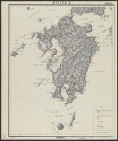
Kyushu
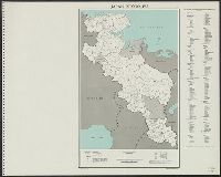
Japan. Aomori-ken : administrative divisions, November 1943 / lithographed in the Reproduction Branch
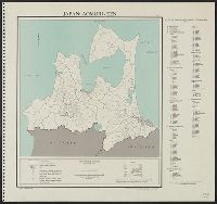
Japan. Ehime-ken : administrative divisions, November 1943
Central Japan (central and northern Honshu) : roads and water routes
Japan, Hiroshima-ken
![City map, central Tokyo, advance edition [cartographic material].](https://stacks.stanford.edu/image/iiif/rr820wk0562%2Frr820wk0562_0001/full/!200,200/0/default.jpg)
City map, central Tokyo, advance edition [cartographic material].

Mandchourie Corée, Japon et côtes orientales de la chine d'après les documents russes, japonais et...
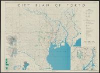
City plan of Tōkyō
Japan : Okayama-ken
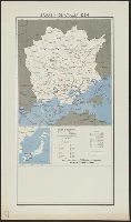
Japan. Kyōto-fu : administrative divisions, November 1943 / lithographed in the Reproduction Branch
最終更新日: 2021-01-30
登録日: 2021-07-29