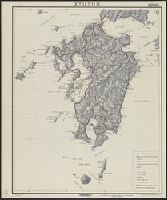
Kyushu
- Time
- Owner Organization

Kyushu

Kyushu

S.E. Kyushu

Northwest Kyushu

Amakusa Bay, Kyushu

Bungo Takeda (Kyushu)

Kokura, Kyushu, Japan

Kitchen Sink, Kyushu, Japan

Mount Aso in Kyushu
Kasteel te Saga op Kyushu

Nagasaki : Nagasaki prefecture, Kyushu, Japan

Miyakonojo, Miyazaki Prefecture, Kyushu, Japan

Japan Series: Kyushu Naked Festival

Oita, Oita-ken, Kyushu, Japan

Japan series: Kyushu Steel Mills

Hitoyoshi, Japan, Kumamoto Ken, Kyushu

Minamata, Japan, Kumamoto Prefecture, Kyushu

Takanabe, Japan, Miyazaki-ken, Kyushu

Shimabara, Japan, Nagasaki-ken, Kyushu

Saeki, Oita Prefecture. Kyushu, Japan

Iizuka, Japan, Fukuoka-ken, Kyushu

Karatsu, Saga Prefecture, Kyushu, Japan

Omura, Nagasaki Prefecture, Kyushu, Japan

Kanda, Fukuoka Prefecture, Kyushu, Japan
Kyushu

Mandchourie Corée, Japon et côtes orientales de la chine d'après les documents russes, japonais et...
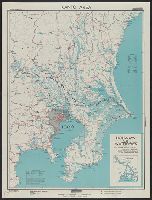
Kantō area : highways and waterways

Japan. Nara-ken : administrative divisions, November 1943 / lithographed in G.P.O. - Department of State Ser...
![Japan and adjacent regions of Asia and the Pacific Ocean [cartographic material] / compiled and drawn in the...](https://collections.library.yale.edu/iiif/2/15510875/full/!200,200/0/default.jpg)
Japan and adjacent regions of Asia and the Pacific Ocean [cartographic material] / compiled and drawn in the...

General map of China and adjacent regions showing treaty ports and railroads / prepared for the Department o...

The Japanese empire : with central and southern Manchukuo (Manchuria)
![Map of Manchuria, Corea & Japan [cartographic material]](https://collections.library.yale.edu/iiif/2/15828540/full/!200,200/0/default.jpg)
Map of Manchuria, Corea & Japan [cartographic material]

map from "What will Japan do? A forecast, etc"

<i>Daily Sketches for Exorcism and Longevity</i>
Estrecho de Simonoseki. H. 106a :entrada occidentral del Seto-Uchi tomados de los trabajos verific...

Strategical map of part of Korea and Manchuria / prepared by the Second Division, General Staff (Military In...

Ise Bay - North :
![Novae Insulae XVII Nova Tabula [First State!]](https://stacks.stanford.edu/image/iiif/sw590fs2648%2F23067/full/!200,200/0/default.jpg)
Novae Insulae XVII Nova Tabula [First State!]
![Novae Insulae XVII Nova Tabula [First State!]](https://stacks.stanford.edu/image/iiif/vz186mx1354%2F22284/full/!200,200/0/default.jpg)
Novae Insulae XVII Nova Tabula [First State!]

Japan electric power / drawn and reproduced by Co B, 942nd Engr. Avn. Topo. Bn, 325th Ric., US Army

Nara, Yamada, Koyasan, & environs

大日本帝國西南部地形圖
![St-Martin : [estampe] / [gypsographie Pierre Roche]](https://api.europeana.eu/thumbnail/v2/url.json?uri=https%3A%2F%2Fgallica.bnf.fr%2Fiiif%2Fark%3A%2F12148%2Fbtv1b105005752%2Ff1%2Ffull%2F512%2C%2F0%2Fnative.jpg&type=IMAGE)
St-Martin : [estampe] / [gypsographie Pierre Roche]

Mandchourie et Coree de Kharbine a Seoul de Port-Arthur a Vladivostok Traduction de la Carte d'Eta...

Nagasaki harbor

房州鋸山乾坤山日本襌寺眞圖

Taira no Kanemori (Object); Hyakunin isshu uba ga etoki (Series)
Twee geisha's
Last Updated: 2021-01-30
Uploaded: 2021-07-29