Map of Korea / prepared by Angus Hamilton F.R.G.S. 1904
- People
- Time
- Owner Organization
Korea / prepared ... by the Army Map Service, U.S. Army

1904 war map of Japan, Korea, and China

1904 war map of Russia and the continent of Asia

Rand, McNally & Co.'s 1904 war map of Russia and the continent of Asia
Japan / prepared by the Army Map Service, (GD) Corps of Engineers, U.S. Army

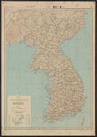
Map of Chosen (Korea)

Strategical map of part of Korea and Manchuria / prepared by the Second Division, General Staff (Military In...
![Map of Chosen (Korea) [cartographic material].](https://stacks.stanford.edu/image/iiif/fx184cf7591%2Ffx184cf7591_0001/full/!200,200/0/default.jpg)
Map of Chosen (Korea) [cartographic material].
Sketch map Darwin / prepared by Australian Section, Imperial General Staff
A map guide to Japan / cartography by H.E.C. Robinson ; text was prepared by ... R.H.P. Mason, Victor Prescott

Bartholomew's special Map of China, Japan and Korea

Bartholomew's Special Map of China, Japan and Korea

Map of Asia

Special war map of China, Korea, and Japan

Strategical Map of Part of Korea and Manchuria . . . 1906
![[Russian Map of Northeastern Asia, Japan, Korea, China, Alaska, etc.] ( Summary map of hydrographi...](https://stacks.stanford.edu/image/iiif/pj697kr2558%2F35405/full/!200,200/0/default.jpg)
[Russian Map of Northeastern Asia, Japan, Korea, China, Alaska, etc.] ( Summary map of hydrographi...

The latest map of Manchuria, Korea, Formosa, and Saghalien

Bilingual map of Greater Tokyo. Prepared by the Cartographic Division of King Associates. Publishe...
![[Taisho Japanese map of the world. Taisho Japanese map of Japan and Korea]. [9 insets].](https://stacks.stanford.edu/image/iiif/yj892bp5625%2F11670000/full/!200,200/0/default.jpg)
[Taisho Japanese map of the world. Taisho Japanese map of Japan and Korea]. [9 insets].
![[Map of Korea] Karta Korei, nyne Yaponskago General-Gubernatorstva Tsiosen, s Yaponskimi Geografic...](https://stacks.stanford.edu/image/iiif/wm529gv6020%2F36877/full/!200,200/0/default.jpg)
[Map of Korea] Karta Korei, nyne Yaponskago General-Gubernatorstva Tsiosen, s Yaponskimi Geografic...
Japan road map 1:1,000,000. sheet 4, Korea / prepared under the direction of the Chief of Engineers, U.S. Ar...
Imperii Sinarum nova descriptio [prepared by Martino Martini]
Map of Japan / by the Welcome Society ; engraved by H. Kobayashi
Tokyo and vicinity : showing bombed-out areas / prepared ... by Nippon Map Co
![Kushiro, Kushiro Sub-prefecture [sic] Hokkaido, Japan](https://stacks.stanford.edu/image/iiif/bf812bp8648%2Fbf812bp8648_0001/full/!200,200/0/default.jpg)
Kushiro, Kushiro Sub-prefecture [sic] Hokkaido, Japan
![Ulan ude [cartographic material]](https://stacks.stanford.edu/image/iiif/zh630gz7261%2Fzh630gz7261_00_0001/full/!200,200/0/default.jpg)
Ulan ude [cartographic material]

Hakodate, Hokkaidō, Japan
![Indo hyakumanbun no ichi zu [cartographic material]](https://stacks.stanford.edu/image/iiif/yh140pd1258%2Fyh140pd1258_00_0001/full/!200,200/0/default.jpg)
Indo hyakumanbun no ichi zu [cartographic material]
![[Shina] Hyakumanbunnoichi Kōkūzu](https://stacks.stanford.edu/image/iiif/sy476vd8533%2Fsy476vd8533_00_0001/full/!200,200/0/default.jpg)
[Shina] Hyakumanbunnoichi Kōkūzu

Wakamatsu, Fukushima Prefecture, Honshu, Japan
Map of Japan

大日本帝國越中國土性圖

Hyakumanbunnoichi Kōkūzu
Japan / by J.G. Bartholomew, F.R.G.S

Ishikawa ken, Japan. (to accompany) Shomitsu Nippon chizu. (Atlas of Japan). Nippon Shoin. (Tokyo,...

肥前国東北部土性図

Gojūmanbun no ichi chishizu

創刊等面積大東亜共栄圏図

Hitachi, Ibaraki Prefecture, Honshu, Japan

Japan and it's relation to the territory bordering on the Pacific ocean
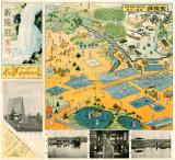
京成電車沿線案内

都市計畫基本圖. : 索引地圖

Tsuchizaki, Akita Prefecture, Honshu, Japan
![Suirobu Hi [Kaizu]](https://stacks.stanford.edu/image/iiif/nm634np1065%2Fnm634np1065_0001/full/!200,200/0/default.jpg)
Suirobu Hi [Kaizu]

Jūmanbun no ichizu Urusha

Kagoshima, Kagoshima Prefecture, Kyushu, Japan
鮫陵源案内 : 鮫陵源淡水魚水禽飼育場遊園と釣魚

大日本国沿海略図
Last Updated: 2020-06-05
Uploaded: 2021-07-22