War map III featuring the Pacific Theater
- Time
- Owner Organization
War map : Australia, China, Japan, and the South Pacific / Cyril Dillon
National Library of Australia
Trove: National Library of Australia
![[World War II battlefronts]. Map VI. The Southwest Pacific. Copyright, 1944, by Remington Rand, In...](https://stacks.stanford.edu/image/iiif/vs321mz7073%2F6758006/full/!200,200/0/default.jpg)
[World War II battlefronts]. Map VI. The Southwest Pacific. Copyright, 1944, by Remington Rand, In...
Stanford University Libraries
Stanford Libraries SearchWorks
Theater of war in the Pacific Ocean / compiled and drawn in the Cartographic Section of the National Geographic Society for the National Geographic Magazine
National Library of Australia
Trove: National Library of Australia
![Theater of war. Episode 2, Under attack, Pearl Harbor [electronic resource] : the Pacific campaign](https://www.gumtree.com/static/1/resources/assets/rwd/images/orphans/a37b37d99e7cef805f354d47.noimage_thumbnail.png)
Theater of war. Episode 2, Under attack, Pearl Harbor [electronic resource] : the Pacific campaign
Stanford University Libraries
Stanford Libraries SearchWorks

On December 7, 1941, Japan struck the first treacherous, devastating blow of the pacific war. Sneaking in fr...
Auckland Libraries
DigitalNZ New Zealand API
Submarines for sale. Four of the seven American submarines, all boasting outstanding Pacific war records, no...
National Library of New Zealand
DigitalNZ New Zealand API
Comparing notes on the map as 5th and 8th Armies meet in Sousse, Tunisia, World War II - Photograph taken by...
Alexander Turnbull Library
DigitalNZ New Zealand API
Printing the cover of NZEF Times in Cairo, Egypt, World War II - Photograph taken by George Bull
Alexander Turnbull Library
DigitalNZ New Zealand API
Editor of the NZEF Times, Mr H L Heatley at his desk in Cairo, Egypt, World War II - Photograph taken by Geo...
Alexander Turnbull Library
DigitalNZ New Zealand API
![Japan and adjacent regions of Asia and the Pacific Ocean [cartographic material] / compiled and drawn in the...](https://collections.library.yale.edu/iiif/2/15510875/full/!200,200/0/default.jpg)
Japan and adjacent regions of Asia and the Pacific Ocean [cartographic material] / compiled and drawn in the...
Yale University Library
Yale University Library Digital Collections

大滿洲國詳圖
Yoshida-South Library, Kyoto University
IIIF Discovery in Japan

1904 war map of Russia and the continent of Asia
Yale University Library
Yale University Library Digital Collections

Asia According to the best Authorities
Stanford University Libraries
Stanford Libraries SearchWorks

The topographic map of Manchoukuo
Stanford University Libraries
Stanford Libraries SearchWorks
A new map of the empires, states, provinces &c of Asia : including also the Turkish & Russian dominions in Europe & New Holland / compiled from the most authentic observations by Robert Wilkinson ; Walsh script. ; W. Palmer sculpt
National Library of Australia
Trove: National Library of Australia
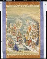
五百羅漢図
Tokyo National Museum
ARC Ukiyo-e Portal Database
![Far East, Japanese occupied area, major railroads [cartographic material] / Board of Economic Warfare, Enemy...](https://collections.library.yale.edu/iiif/2/15510697/full/!200,200/0/default.jpg)
Far East, Japanese occupied area, major railroads [cartographic material] / Board of Economic Warfare, Enemy...
Yale University Library
Yale University Library Digital Collections
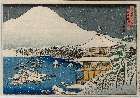
「都名所之内」 「金閣寺雪景」
Museum of Fine Arts, Boston
ARC Ukiyo-e Portal Database

U.S.S.R. - Far East, Korea, Japan. Pergamon World Atlas. Pergamon Press, Ltd. & P.W.N. Poland 1967...
Stanford University Libraries
Stanford Libraries SearchWorks

Chinese Empire (including Trans Oceanic Cables to Hong Kong,etc.)
Stanford University Libraries
Stanford Libraries SearchWorks

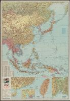
A Map of the East-Indies and the Adjacent Countries; with the Settlements, Factories and Territori...
Stanford University Libraries
Stanford Libraries SearchWorks
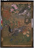
花鳥図
Tokyo National Museum
ARC Ukiyo-e Portal Database

Nagasaki
Yale University Library
Yale University Library Digital Collections
Last Updated: 2021-01-30
Uploaded: 2021-07-29