![Tokyo city proper [cartographic material]](https://stacks.stanford.edu/image/iiif/vj067cj0650%2Fvj067cj0650_00_0001/full/!200,200/0/default.jpg)
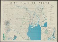
Tokyo city proper [cartographic material]

Tokyo city plan
Tokyo city plan : Marunouchi

Map of Tokyo : city communications
![[The Bridge of Tokyo City.]](https://api.europeana.eu/api/v2/thumbnail-by-url.json?uri=http%3A%2F%2Fwww.beeldbankwo2.nl%2Fcgi-bin%2Ffrsiserver.dll%2Fthumbnail%2F49348-thumb.jpg%3Ffrskey%3D49348&type=IMAGE)
[The Bridge of Tokyo City.]

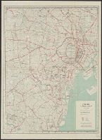
Central Tokyo : city map.

New Tokyo City Hall: Design Drawings. Tokyo, Japan
Tokyo City Information Centre brochure
![[The Bridges of Tokyo - City.]](https://api.europeana.eu/api/v2/thumbnail-by-url.json?uri=http%3A%2F%2Fwww.beeldbankwo2.nl%2Fcgi-bin%2Ffrsiserver.dll%2Fthumbnail%2F49322-thumb.jpg%3Ffrskey%3D49322&type=IMAGE)
[The Bridges of Tokyo - City.]

Map of Tōkyō : city communications / printed by the Tokyo Printing Co., Ltd
Tokyo City Map
Tokyo City Map

THE "GRAND CANAL" OF TOKYO, THE CAPITAL CITY OF JAPAN
![Tokyo waka [electronic resource] : a city poem](https://www.gumtree.com/static/1/resources/assets/rwd/images/orphans/a37b37d99e7cef805f354d47.noimage_thumbnail.png)
Tokyo waka [electronic resource] : a city poem
City plan of Tōkyō
![The city of Yedo or Edo (now Tokyo) [detail]](http://s3.amazonaws.com/ourheritagemedia/square_thumbnails/c189ad0e3ecd6d38cf88133179ecea43.jpg)
The city of Yedo or Edo (now Tokyo) [detail]
![City map, central Tokyo, advance edition [cartographic material].](https://stacks.stanford.edu/image/iiif/rr820wk0562%2Frr820wk0562_0001/full/!200,200/0/default.jpg)
City map, central Tokyo, advance edition [cartographic material].

Osaka-Kobe area: Kobe Proper: Hyogo Prefecture, Honshu, Japan

Sister city visitors, Manukau City, 1985
Helix City Project, Tokyo, Japan (Plan)
City map, central Tokyo. December 1946 / prepared under direction of the chief engineer, general headquarter...

Chuoichiba Market, Tsukuji, Tokyo

City Crowd Series

Japan series: city
Tokyo city proper [cartographic material]

甲陽郭衢近河全圖
Dai ichi-gun no heitan : Meiji sanjūnana-nen hachi-gatsu nijūgo nichi
On Edo ōezu : Stad Iedo
Laurie and Whittle's new chart of the Indian and Pacific Oceans between the Cape of Good Hope, New Holland and Japan : comprehending New Zealand, New Caledonia, New Britain, New Ireland, New Guinea &c., Louisiade and New Georgia; also The Pelew, New Caroline, Ladrone and Philippine Islands &c. with the most remarkable tracks of the English, Spanish, French and Dutch navigators and chiefly the track of the Walpole, EastIndiaman, Captn. Thos. Butler, 1794 from the Cape of Good Hope to Van Diemen's Land and from thence to China, and the track of the Royal Admiral Captn. Henr. Bond in 1792 and 93 from the Cape to Port Jackson and China

(虹) 「虹」「虹ハ微薄ノ雨ニ日光映シテ五彩ヲナス」

「山崎屋娘おてる 岩井半四郎」
A new chart of the Indian and Pacific Oceans between the Cape of Good Hope, New Holland and Japan : comprehending New Zealand, New Caledonia, New Britain, New Ireland, New Guinea &c., also the New Caroline, Ladrone and Philippine Islands : with the tracks of the English, French, Spanish and Dutch discoverers
Nieuwe wassende graet kaert van Oost Indien van d. C. d Bono Esperanca tot t'Lant Eso / gedruckt by I. Robyn met Privilege

四日市航空寫眞測量圖

駿河国富士山頂上八葉内院八方遠見図

甲斐国全図
「当世葉うた合」

「西国三十三所順拝地図」
「三代瀬川菊之丞(せがわきくのじょう)」
![[清図]「射水郡今開発村領見取絵図」文化九年四月](https://adeac.jp/items/imizu-shinminato-mus/catalog/mp102000-15100/3-1-BII78v2.jpg)
[清図]「射水郡今開発村領見取絵図」文化九年四月
![[Cat with black markings on its fur and a fragrant rose mallow]](https://tile.loc.gov/storage-services/service/pnp/jpd/02400/02429_150px.jpg)
[Cat with black markings on its fur and a fragrant rose mallow]
To the Right Honourable William, Lord Cowper, Lord High Chancellor of Great Britain, this map of Asia : according to ye newest and most exact observations is most humbly dedicated / by your Lordship's most humble servant, Herman Moll, geographer

Plata Americae Provincia

Carte Des Indes et de la Chine Dressee sur plusieurs Relations particulieres Rectifees par quelque...

駿河國安倍郡志豆機山浅間惣社御社中御繪圖面.

「お七 岩井粂三郎」
![[下図]「惣高千八拾五石免四ツ射水郡今井村惣高廻内検地領絵図下書」寛政十二年九月十日](https://adeac.jp/items/imizu-shinminato-mus/catalog/mp101810-15100/3-1-BII35v2.jpg)
[下図]「惣高千八拾五石免四ツ射水郡今井村惣高廻内検地領絵図下書」寛政十二年九月十日

A Correct Sea Chart of the Whole World, According to Wright's, Commonly Called Mercator's, Project...
最終更新日: 2020-06-05
登録日: 2021-07-22