
U.S.S.R. - Far East, Korea, Japan. Pergamon World Atlas. Pergamon Press, Ltd. & P.W.N. Poland 1967...

Japan. Pergamon World Atlas. Pergamon Press, Ltd. & P.W.N. Poland 1967. Sluzba Topograficzna W.P
スタンフォード大学図書館
スタンフォード大学図書館SearchWorks

Japan - North. Tokyo Bay. Pergamon World Atlas. Pergamon Press, Ltd. & P.W.N Poland 1967. Sluzba T...
スタンフォード大学図書館
スタンフォード大学図書館SearchWorks

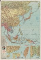
South China Sea. South East Asia - Selected Areas. Pergamon World Atlas. Pergamon Press, Ltd. & P....
スタンフォード大学図書館
スタンフォード大学図書館SearchWorks

123-124. Japan. The World Atlas
スタンフォード大学図書館
スタンフォード大学図書館SearchWorks
1908. Far East Japan
ヴィクトリア・アンド・アルバート博物館
ヴィクトリア・アンド・アルバート博物館API
![[Railroads in China, Manchuria, Korea, Japan and the eastern U.S.S.R.] [cartographic material]](https://stacks.stanford.edu/image/iiif/pf710vm7134%2Fpf710vm7134_00_0001/full/!200,200/0/default.jpg)
[Railroads in China, Manchuria, Korea, Japan and the eastern U.S.S.R.] [cartographic material]
スタンフォード大学図書館
スタンフォード大学図書館SearchWorks

(Map of the world). (to accompany) Shomitsu Nippon chizu. (Atlas of Japan). Nippon Shoin. (Tokyo, ...
スタンフォード大学図書館
スタンフォード大学図書館SearchWorks
![[Taisho Japanese map of the world. Taisho Japanese map of Japan and Korea]. [9 insets].](https://stacks.stanford.edu/image/iiif/yj892bp5625%2F11670000/full/!200,200/0/default.jpg)
[Taisho Japanese map of the world. Taisho Japanese map of Japan and Korea]. [9 insets].
スタンフォード大学図書館
スタンフォード大学図書館SearchWorks

Stieler's Hand-Atlas No. 65. China (Ostl. Theil.), Korea und Japan. (insets) Schang-hai. Tokyo. Ca...
スタンフォード大学図書館
スタンフォード大学図書館SearchWorks

Big in Japan? - German mineral water for the Far East
ドイチェ・ヴェレ
ヨーロピアナAPI

Rand, McNally & Company's indexed atlas of the world map of Japan Copyright 1892, by Rand, McNally...
スタンフォード大学図書館
スタンフォード大学図書館SearchWorks

China, Engraved Expressly for the Standard World Atlas. (inset) Japan or Nippon
スタンフォード大学図書館
スタンフォード大学図書館SearchWorks

The JVC video anthology of world music and dance. Volume 1, East Asia I : Korea 1
スタンフォード大学図書館
スタンフォード大学図書館SearchWorks

Map of Japan. Published by George F. Cram, Chicago, Ill. (to accompany) Cram's atlas of the world,...
スタンフォード大学図書館
スタンフォード大学図書館SearchWorks

Bartholomew's special Map of China, Japan and Korea
フランス国立図書館
ヨーロピアナAPI

Special war map of China, Korea, and Japan
スタンフォード大学図書館
スタンフォード大学図書館SearchWorks

125. Tokyo and Yokohama. Kobe and Osaka. The World Atlas
スタンフォード大学図書館
スタンフォード大学図書館SearchWorks

Shu, So og Sho. Den fjernøstlige bog. Kina, Korea og Japan
デンマーク王立図書館
ヨーロピアナAPI

Korea, Nordost-China und Süd-Japan / Carl Flemming
フランス国立図書館
ヨーロピアナAPI

(Map of Tao, Japan). (to accompany) Shomitsu Nippon chizu. (Atlas of Japan). Nippon Shoin. (Tokyo,...
スタンフォード大学図書館
スタンフォード大学図書館SearchWorks

Tokyo, Japan. (to accompany) Shomitsu Nippon chizu. (Atlas of Japan). Nippon Shoin (Tokyo, 1956)
スタンフォード大学図書館
スタンフォード大学図書館SearchWorks

Kamikochi, Japan. (to accompany) Shomitsu Nippon chizu. (Atlas of Japan). Nippon Shoin. (Tokyo, 19...
スタンフォード大学図書館
スタンフォード大学図書館SearchWorks

Tokyo central, Japan. (to accompany) Shomitsu Nippon chizu. (Atlas of Japan). Nippon Shoin. (Tokyo...
スタンフォード大学図書館
スタンフォード大学図書館SearchWorks

Tokyoto Japan. (to accompany) Shomitsu Nippon chizu. (Atlas of Japan). Nippon Shoin (Tokyo, 1956)
スタンフォード大学図書館
スタンフォード大学図書館SearchWorks
South China Sea. South East Asia - Selected Areas. Pergamon World Atlas. Pergamon Press, Ltd. & P....
スタンフォード大学図書館
スタンフォード大学図書館SearchWorks

Japon, Corée et Mandchourie méridionale pour suivre les opérations militaires / dressée d'après le...
フランス国立図書館
ヨーロピアナAPI
![Japan and adjacent regions of Asia and the Pacific Ocean [cartographic material] / compiled and drawn in the...](https://collections.library.yale.edu/iiif/2/15510875/full/!200,200/0/default.jpg)
Japan and adjacent regions of Asia and the Pacific Ocean [cartographic material] / compiled and drawn in the...
イェール大学図書館
イェール大学図書館デジタルコレクション
Japan - North. Tokyo Bay. Pergamon World Atlas. Pergamon Press, Ltd. & P.W.N Poland 1967. Sluzba T...
スタンフォード大学図書館
スタンフォード大学図書館SearchWorks

The topographic map of Manchoukuo
スタンフォード大学図書館
スタンフォード大学図書館SearchWorks

百万分一 満洲國輿地圖
スタンフォード大学図書館
スタンフォード大学図書館SearchWorks

Japanese Empire - political. The Edinburgh Geographical Institute, John Bartholomew & Son, Ltd. "T...
スタンフォード大学図書館
スタンフォード大学図書館SearchWorks

New Map of Japan
スタンフォード大学図書館
スタンフォード大学図書館SearchWorks
![Map of Manchuria, Corea & Japan [cartographic material]](https://collections.library.yale.edu/iiif/2/15828540/full/!200,200/0/default.jpg)
Map of Manchuria, Corea & Japan [cartographic material]
イェール大学図書館
イェール大学図書館デジタルコレクション
![Far East, Japanese occupied area, major railroads [cartographic material] / Board of Economic Warfare, Enemy...](https://collections.library.yale.edu/iiif/2/15510697/full/!200,200/0/default.jpg)
Far East, Japanese occupied area, major railroads [cartographic material] / Board of Economic Warfare, Enemy...
イェール大学図書館
イェール大学図書館デジタルコレクション

Hitome de wakaru shina jihen to nisso kankei e chizu. (Drawn by) Eisuke Ishida. Showa 12 (1937). (...
スタンフォード大学図書館
スタンフォード大学図書館SearchWorks
Hitome de wakaru shina jihen to nisso kankei e chizu. (Drawn by) Eisuke Ishida. Showa 12 (1937). (...
スタンフォード大学図書館
スタンフォード大学図書館SearchWorks

Tabula Tartariae et majoris partis regni Chinae / edita a F. de Wit ; Lhuilier fecit
イェール大学図書館
イェール大学図書館デジタルコレクション

Japanese Empire. Copyright "Geographia" Map Co. (Produced by) Alexander Gross, F.R.G.S. (inset map...
スタンフォード大学図書館
スタンフォード大学図書館SearchWorks

「江戸名所四十八景」 「日くらしの里」「十二」
ボストン美術館
ARC浮世絵ポータルデータベース
Esso war map III featuring the Pacific Theater : a third war map / edited, drafted and printed by the makers...
イェール大学図書館
イェール大学図書館デジタルコレクション
最終更新日: 2020-04-17
登録日: 2021-09-21