
Japanese Empire - political. The Edinburgh Geographical Institute, John Bartholomew & Son, Ltd. "T...
- Time
- Owner Organization

Japan. The Edinburgh Geographical Institute, John Bartholomew & Co "The Times" atlas. (London: The...

Japan. Edited by John Bartholomew, M.C., LL.D. The Geographical Institute Edinburgh Copyright, Joh...

China N. E. Korea Sea of Japan. Edited by John Bartholomew, M.C., LL.D. The Geographical Institute...

Map of the Great Japanese Empire (Dainihon Kokugun Yochi Zenzu)

Topographical map of the Japanese Empire, 1899 / Imperial Geological Survey of Japan ; drawn by T. Togawa an...

Dai Nihon zenzu (The picture of the Great Whole Map of Japan; Provinces in the Japanese Empire, in...

The silk industry of Japan, by I. Honda, director of the Imperial Tokyo sericultural institute
The silk industry of Japan, by I. Honda, director of the Imperial Tokyo sericultural institute
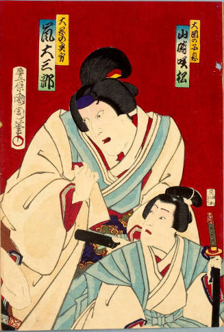
Political Talk about Tenichibō case by ōoka Echizen : Yamazaki Sakimatsu as Son of ōoka, Arashi Daizaburō as ōoka's Wife
Stanford's London atlas of universal geography exhibiting the physical and political divisions of the various countries of the world

A Great Battle Between Japan and China: The Army of the Japanese Empire Expel the Chinese Troops from Asan, Korea (Nisshin daisensō teikokugun Gazan no Shinhei uchiharau no zu)
[When he was Prime Minister after the death of Harold Holt, John McEwen asked Sir Charles Spry, the head of ASIO, for information about Maxwell Newton, a journalist associated with McEwan's political rival, Bill McMahon, and who was a publicist for the Japan External Trade Organisation (JETRO)] O'Neill
Tsunamis in the Pacific Basin, 1900-1983 / map produced by Patricia A. Lockridge, National Geophysical Data Center and Ronald H. Smith, Cooperative Institute for Research in Environmental Sciences ; published by National Geophysical Data Center and World Data Center A for Solid Earth Geophysics with support from Office of U.S. Foreign Disaster Assistance, Agency for International Development in cooperation with Circum-Pacific Council for Energy and Mineral Resources, Map Project
Japan. The Edinburgh Geographical Institute, John Bartholomew & Co "The Times" atlas. (London: The...

Plate 3. Japan and Korea. Extension to Formosa and Lu-Chu Islands

Giappone, Nihon. Propr. Artistico-letteraria del T.C.I. Ufficio cartografico del T.C.I. (1929)

Japan and Korea. (with) The Japanese Empire. (with) Port Arthur and Adjacent Territory. (with) For...

Asien und Europa. (with) Japan von Dr. Edm. Naumann, Korea von Dr. C. Gottsche (with) Indisches Sa...

Empire of Japan, Yedo ... Meaco. (insets) Nagasaki Harbour. Eastern Point of Yeso

Rand, McNally & Company's indexed atlas of the world map of Japan Copyright 1892, by Rand, McNally...

Chiba-ken, Japan. (to accompany) Shomitsu Nippon chizu. (Atlas of Japan). Nippon Shoin. (Tokyo, 19...

Asia (Eastern Sheet)

China and Japan

Palestine. Japan

China and Japan. London: Published by Henry Teesdale & Co. Drawn & Engraved by J. Dower, Pentonvil...

No. 39. Asiatische Inselwelt

China. (with) Islands of Japan. By Keith Johnston, F.R.S.E. Keith Johnston's General Atlas. Engrav...
「(狂斎百図)馬士ニモ位装」

Nr. 65. Japan, Korea und Ost-China. ... C. Barich

Chinese and Japanese ports. (with) The mainland of Japan with the islands of Kiushiu & Shikoku. Ge...
Japan. Edited by John Bartholomew, M.C., LL.D. The Geographical Institute Edinburgh Copyright, Joh...
![Exactissima Asiae delineatio, in praecipuas regiones, ceterasq [cartographic material] : partes divisa, et d...](https://collections.library.yale.edu/iiif/2/16618498/full/!200,200/0/default.jpg)
Exactissima Asiae delineatio, in praecipuas regiones, ceterasq [cartographic material] : partes divisa, et d...

Palestine. Japan

豊橋市街図 二万八千分の一 昭和13年

Ehime ken, Japan. (to accompany) Shomitsu Nippon chizu. (Atlas of Japan. Nihon shosha editorial se...

Toukyousanjuurokkei sanjuugo asukayama

Hakamada wan, Japan. (to accompany) Shomitsu Nippon chizu. (Atlas of Japan. Nihon shosha editorial...
Last Updated: 2020-04-17
Uploaded: 2021-09-21