
Bartholomew's special Map of China, Japan and Korea
- Time
- Owner Organization

Special war map of China, Korea, and Japan
Stanford University Libraries
Stanford Libraries SearchWorks
![[Russian Map of Northeastern Asia, Japan, Korea, China, Alaska, etc.] ( Summary map of hydrographi...](https://stacks.stanford.edu/image/iiif/pj697kr2558%2F35405/full/!200,200/0/default.jpg)
[Russian Map of Northeastern Asia, Japan, Korea, China, Alaska, etc.] ( Summary map of hydrographi...
Stanford University Libraries
Stanford Libraries SearchWorks

China. Japan. Korea
Stanford University Libraries
Stanford Libraries SearchWorks
![[Taisho Japanese map of the world. Taisho Japanese map of Japan and Korea]. [9 insets].](https://stacks.stanford.edu/image/iiif/yj892bp5625%2F11670000/full/!200,200/0/default.jpg)
[Taisho Japanese map of the world. Taisho Japanese map of Japan and Korea]. [9 insets].
Stanford University Libraries
Stanford Libraries SearchWorks

Rand, McNally & Co.'s 1904 war map of Russia and the continent of Asia
Yale University Library
Yale University Library Digital Collections

1904 war map of Japan, Korea, and China
Yale University Library
Yale University Library Digital Collections

1904 war map of Russia and the continent of Asia
Yale University Library
Yale University Library Digital Collections
![[Map of China]](https://collections.library.yale.edu/iiif/2/16189150/full/!200,200/0/default.jpg)
[Map of China]
Yale University Library
Yale University Library Digital Collections

Map of Chosen (Korea)
Yale University Library
Yale University Library Digital Collections
![China and Japan [cartographic material]](https://collections.library.yale.edu/iiif/2/15828553/full/!200,200/0/default.jpg)
China and Japan [cartographic material]
Yale University Library
Yale University Library Digital Collections

Japan and Korea
Stanford University Libraries
Stanford Libraries SearchWorks
Map of Japan
Univerzita Karlova. Mapová sbírka
Europeana API

Map of Japan
Boston Public Library
DPLA API

Map of Japan
Stanford University Libraries
Stanford Libraries SearchWorks

Map of Japan
Library of Congress
Digital Collections, Library of Congress
![Map of Chosen (Korea) [cartographic material].](https://stacks.stanford.edu/image/iiif/fx184cf7591%2Ffx184cf7591_0001/full/!200,200/0/default.jpg)
Map of Chosen (Korea) [cartographic material].
Stanford University Libraries
Stanford Libraries SearchWorks

The latest map of Manchuria, Korea, Formosa, and Saghalien
Stanford University Libraries
Stanford Libraries SearchWorks
![Japan [and Korea]](https://stacks.stanford.edu/image/iiif/xv761my3964%2F41979/full/!200,200/0/default.jpg)
Japan [and Korea]
Stanford University Libraries
Stanford Libraries SearchWorks

Rand, McNally & Co.'s China. Chinese Empire with Japan and Korea
Stanford University Libraries
Stanford Libraries SearchWorks

Travel views of Japan and Korea
Library of Congress
Digital Collections, Library of Congress

Travel views of Japan and Korea
Library of Congress
Digital Collections, Library of Congress

Travel views of Japan and Korea
Library of Congress
Digital Collections, Library of Congress

Travel views of Japan and Korea
Library of Congress
Digital Collections, Library of Congress

Travel views of Japan and Korea
Library of Congress
Digital Collections, Library of Congress

Mandchourie et Coree de Kharbine a Seoul de Port-Arthur a Vladivostok Traduction de la Carte d'Eta...
Stanford University Libraries
Stanford Libraries SearchWorks
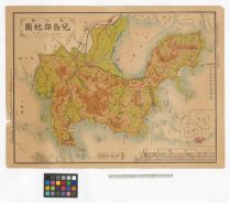
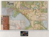
岡山県児島郡地図
Tamano City Library
ADEAC: A System of Digitalization and Exhibition for Archive Collections
The latest map of Manchuria, Korea, Formosa, and Saghalien
Stanford University Libraries
Stanford Libraries SearchWorks

Regni Japoniae nova mappa geographica , ex indigenarum observationibus delineata ab Engelberto Kae...
Bibliothèque nationale de France
Europeana API
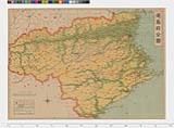
徳島県日本新分県地図
Tokushima Prefectural Archives
ADEAC: A System of Digitalization and Exhibition for Archive Collections
Goshu Indo zenzu : tsuketari Soromon Nyu Ginia oyobi Nanpo gunto shosaizu
National Library of Australia
Trove: National Library of Australia
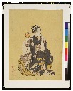
見立大黒天
Tokyo National Museum
ARC Ukiyo-e Portal Database
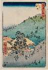
「五十三次名所図会」 「丗四」「二川」「猿か馬場(さるがばば)立橋(たてはし)」
Museum of Fine Arts, Boston
ARC Ukiyo-e Portal Database
京成電車沿線案内
Funabashi-shi Western Library
ADEAC: A System of Digitalization and Exhibition for Archive Collections

「桜姫 瀬川菊之丞」
British Museum
ARC Ukiyo-e Portal Database
Last Updated:
Uploaded: 2021-07-27