Hitome de wakaru shina jihen to nisso kankei e chizu. (Drawn by) Eisuke Ishida. Showa 12 (1937). (...
- People
- Time
- Owner Organization

Hitome de wakaru shina jihen to nisso kankei e chizu. (Drawn by) Eisuke Ishida. Showa 12 (1937). (...
Stanford University Libraries
Stanford Libraries SearchWorks

The war comes home to Japan. Los Angeles Evening Herald and Express
Stanford University Libraries
Stanford Libraries SearchWorks
![Manshūkoku yochizu [cartographic material] : hyakumanbun no ichi](https://stacks.stanford.edu/image/iiif/dc116hp3130%2Fdc116hp3130_00_0001/full/!200,200/0/default.jpg)
Manshūkoku yochizu [cartographic material] : hyakumanbun no ichi
Stanford University Libraries
Stanford Libraries SearchWorks

The topographic map of Manchoukuo
Stanford University Libraries
Stanford Libraries SearchWorks

大日本帝国播磨但馬淡路全国摂津国西部丹波国西南部兵庫県管内土性図
Yoshida-South Library, Kyoto University
IIIF Discovery in Japan

U.S.S.R. - Far East, Korea, Japan. Pergamon World Atlas. Pergamon Press, Ltd. & P.W.N. Poland 1967...
Stanford University Libraries
Stanford Libraries SearchWorks

Spatiosissimum Imperium Russiae Magnae juxta recentissimas Observationes Mappa Geographica . .
Stanford University Libraries
Stanford Libraries SearchWorks

Asie Orientale. Chine & Japon . . . 1860
Stanford University Libraries
Stanford Libraries SearchWorks

大日本帝國越中國土性圖
Yoshida-South Library, Kyoto University
IIIF Discovery in Japan
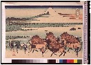
「富嶽三十六景」 「駿州 大野新田」
Tokyo National Museum
ARC Ukiyo-e Portal Database
![Japan and adjacent regions of Asia and the Pacific Ocean [cartographic material] / compiled and drawn in the...](https://collections.library.yale.edu/iiif/2/15510875/full/!200,200/0/default.jpg)
Japan and adjacent regions of Asia and the Pacific Ocean [cartographic material] / compiled and drawn in the...
Yale University Library
Yale University Library Digital Collections

創刊等面積大東亜共栄圏図
Yoshida-South Library, Kyoto University
IIIF Discovery in Japan

The Empire of China and Island of Japan, Agreeable to Modern History
Stanford University Libraries
Stanford Libraries SearchWorks

Imperii Russici et Tatariae Universae tam majoris et Asiaticae quam minoris et Europae Tabula . .....
Stanford University Libraries
Stanford Libraries SearchWorks
![Tokyo and vicinity, showing bombed-out areas [cartographic material]](https://stacks.stanford.edu/image/iiif/jx217xm7539%2Fjx217xm7539_00_0001/full/!200,200/0/default.jpg)
Tokyo and vicinity, showing bombed-out areas [cartographic material]
Stanford University Libraries
Stanford Libraries SearchWorks

Karte des Amur-Landes nach den neuesten Quellen und mit Benutzung der Angeben von L. v. Schrenk un...
Stanford University Libraries
Stanford Libraries SearchWorks
Last Updated: 2020-04-17
Uploaded: 2021-09-21