

China. (inset) Japan or Nippon

Town plan of Otomari : Japan: Karafuto

Town plan of Toyohara : Japan: Karafuto

China, Japan, and Mongolia. (inset) Hong Kong and Vicinity

Johnson's China and Japan. Entered ... 1868. (inset) Vicinity of Canton and Hong Kong

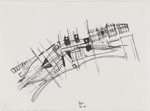
Church of the Light, Ibaraki, Osaka, Japan (Plan)
Church of the Light, Ibaraki, Osaka, Japan, Plan

Church of the Light, Ibaraki, Osaka, Japan, Plan

China, Engraved Expressly for the Standard World Atlas. (inset) Japan or Nippon

Nihon Nankyoku tanken-zu. (Illustration of Japanese Exploration of the Antarctic). (inset: locatio...

Plan of Yokohama

Japan (with Formosa Island Inset)

Japan Series: Tokyo Bay

Japan : Karafuto, town plan of Ochiai

Japan : Karafuto : town plan of Ōtomari
City plan of Yokohama

A map of China : Published by K. Saito. Osaka Japan. Sole agent T. Kishida & Co. Shanghai. (inset ...

Town plan of Wakayama

City plan of Kōbe.

Reconstruction plan of Yokohama
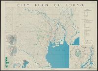
City plan of Tōkyō
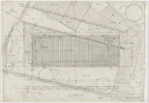
Town Plan Project, Kobe, Japan, Site plan
A map of China : Published by K. Saito. Osaka Japan. Sole agent T. Kishida & Co Shanghai. (inset m...

Plan of house and garden

Japan. Copyright 1892 by Appleton & Co. (insets) Kurile Islands; Tokyo. (to accompany) The Library...

Carte des decouvertes au nord du Japon. Faites en 1643 par les Vaisseaux Hollandais le Kastrikum e...

Japan. (with) Kurile Islands. Letts's popular atlas. Letts, Son & Co Limited, London. (1883)

Japan

Japan. London atlas series. Stanford's Geographical Establishment. London : Edward Stanford, 26 & ...

Carte des decouvertes, faites en 1787 dans les mers de Chine et de Tartarie par les Fregates Franc...

Partie du Japon. Asie no. 61. (Dresse par Ph. Vandermaelen, lithographie par H Ode. Deuxieme parti...

Empire of Japan. (with) Nagasaki Harbour. Engraved by J. & C. Walker. Published under the superint...

Empire of Japan, Yedo ... Meaco. (insets) Nagasaki Harbour. Eastern Point of Yeso

Plate 3. Japan and Korea. Extension to Formosa and Lu-Chu Islands

China, Japan &c. (to accompany) A Comprehensive Atlas, Geographical Historical & Commercial. By T....

Chart of Discoveries made in 1787 In the Seas of China and Tartary between Manilla and Avateha by ...

Map of Japan. Published by George F. Cram, Chicago, Ill. (to accompany) Cram's atlas of the world,...

Giappone, Nihon. Propr. Artistico-letteraria del T.C.I. Ufficio cartografico del T.C.I. (1929)

A new and accurate map of the Empire of Japan. Laid down from the memoirs of the Portuguese and Du...

Das Chinesische Reich mit den Schutz-Staaten, und Japan: entw. u. gez. v. C.G R.(eichard) 1826. Ge...

Asia divided into its principall regions in which may be seen the extent of the empires, monarchies, kingdom...
![Japan [cartographic material] : Kyushu north coast](https://stacks.stanford.edu/image/iiif/gy001xy3796%2Fgy001xy3796_00_0001/full/!200,200/0/default.jpg)
Japan [cartographic material] : Kyushu north coast
Johnson's China and Japan. Entered ... 1868. (inset) Vicinity of Canton and Hong Kong

Empire of Japan ... Published under the Supervision of the Society for the Diffusion of Useful Kno...

Iaponia Regnvm
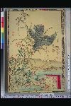
「楳嶺花鳥画譜」 「芦」「鷂」

China. (to accompany) The Columbian World's Fair atlas ... Published for: Wood Brothers Cash Store...

Asia : Coast of China : Ryōtō Kaiwan. Approaches to Ryō Ga Entrance
最終更新日: 2020-04-17
登録日: 2021-09-21