
Empire of Japan, Yedo ... Meaco. (insets) Nagasaki Harbour. Eastern Point of Yeso
- Time
- Owner Organization

Empire of Japan. (with) Nagasaki Harbour. Engraved by J. & C. Walker. Published under the superint...
Stanford University Libraries
Stanford Libraries SearchWorks
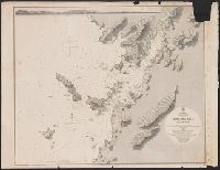
Japan Kiusiu Island, West Coast. Nagasaki Harbour, 1861 / engraved by Davies & Powell
Yale University Library
Yale University Library Digital Collections
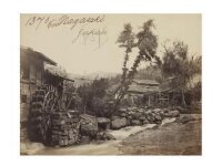
Nagasaki. Japan
Victoria and Albert Museum
Victoria and Albert Museums API

Empire of Japan . .
Stanford University Libraries
Stanford Libraries SearchWorks

Empire of Japan
Stanford University Libraries
Stanford Libraries SearchWorks

Nagasaki, Nagasaki Prefecture, Kyushu, Japan
Stanford University Libraries
Stanford Libraries SearchWorks

INSIDE NAGASAKI HARBOUR: AN IMPORTANT JAPANESE NAVAL BASE
Auckland Libraries
DigitalNZ New Zealand API
Landkarte des: Empire of Japan/Kaiserreich Japan
Digitales Kunst- und Kulturarchiv Düsseldorf
Europeana API

Map of the Empire of Japan
Salem State University Archives and Special Collections
DPLA API

Japan Series: Nagasaki Shipbuilding
Museum of New Zealand Te Papa Tongarewa
DigitalNZ New Zealand API

Japan Series: Nagasaki Shipbuilding
Museum of New Zealand Te Papa Tongarewa
DigitalNZ New Zealand API

Japan Series: Nagasaki Shipyards
Museum of New Zealand Te Papa Tongarewa
DigitalNZ New Zealand API

Martelaren van Japan Nagasaki
Museum De Mindere, Sint-Truiden
Europeana API

Kanayacho, Nagasaki, from the series Selection of scenes of Japan
Freer and Sackler
DPLA API
Nagasaki Bombs over Japan Th...
Cineteca di Bologna
Europeana API

Japan Series: Nagasaki Shipbuilding Yards
Museum of New Zealand Te Papa Tongarewa
DigitalNZ New Zealand API

Japan Series: Nagasaki Shipbuilding Yards
Museum of New Zealand Te Papa Tongarewa
DigitalNZ New Zealand API

Manchuria. Korea. Japan. (insets) (Vicinity of Osaka and Tokyo)
Stanford University Libraries
Stanford Libraries SearchWorks

Kanaya-cho, Nagasaki, from the series "Selection of Scenes of Japan" (Nihon fukei senshu, Nagasaki Kanaya-cho)
Art Institute of Chicago
Art Institute of Chicago API

Shimabara, Japan, Nagasaki-ken, Kyushu
Stanford University Libraries
Stanford Libraries SearchWorks

Isahaya, Japan, Nagasaki-ken, Kyushū.
Stanford University Libraries
Stanford Libraries SearchWorks

Omura, Nagasaki Prefecture, Kyushu, Japan
Stanford University Libraries
Stanford Libraries SearchWorks
![Japan, Nagasaki-ken [cartographic material]](https://stacks.stanford.edu/image/iiif/mr952zz4202%2Fmr952zz4202_00_0001/full/!200,200/0/default.jpg)
Japan, Nagasaki-ken [cartographic material]
Stanford University Libraries
Stanford Libraries SearchWorks

Samurai (Harada Kiichi), Nagasaki, Japan
Museum of Fine Arts, Houston
Museum of Fine Arts, Houston
Empire of Japan. (with) Nagasaki Harbour. Engraved by J. & C. Walker. Published under the superint...
Stanford University Libraries
Stanford Libraries SearchWorks

Map of Asia showing its gt. political divisions, and also various routes of travel between London ...
Stanford University Libraries
Stanford Libraries SearchWorks
![Il conflitto Russo-Giappanese : [map of the region]](https://collections.library.yale.edu/iiif/2/15828541/full/!200,200/0/default.jpg)
Il conflitto Russo-Giappanese : [map of the region]
Yale University Library
Yale University Library Digital Collections

Empire of Japan ... Published under the Supervision of the Society for the Diffusion of Useful Kno...
Stanford University Libraries
Stanford Libraries SearchWorks

「大日本六十余州名勝図会」 「美濃」「養老ノ滝」
National Diet Library, Japan
ARC Ukiyo-e Portal Database

Palestine. Japan
Stanford University Libraries
Stanford Libraries SearchWorks

Palestine. Japan
Stanford University Libraries
Stanford Libraries SearchWorks

Japan. (with) Kurile Islands. Letts's popular atlas. Letts, Son & Co Limited, London. (1883)
Stanford University Libraries
Stanford Libraries SearchWorks

Plate 3. Japan and Korea. Extension to Formosa and Lu-Chu Islands
Stanford University Libraries
Stanford Libraries SearchWorks

Nieuwe Kaart van't Keizerryk. Japan na de Nieuste ontdekkingen
Yale University Library
Yale University Library Digital Collections

Japanese Empire - political. The Edinburgh Geographical Institute, John Bartholomew & Son, Ltd. "T...
Stanford University Libraries
Stanford Libraries SearchWorks
禽虫之図
Tokyo National Museum
ARC Ukiyo-e Portal Database

Chart of the Discoveries to the North of Japan, in 1643, by the Dutch Ships the Kastrikum & the Br...
Stanford University Libraries
Stanford Libraries SearchWorks

China and Japan. (with) Islands of Japan. By Keith Johnston, F.R.S.E. Keith Johnston's General Atl...
Stanford University Libraries
Stanford Libraries SearchWorks

Corea and Japan. J. & G. Menzies sculpt., Edinr. Drawn & engraved for Thomson's New general atlas,...
Stanford University Libraries
Stanford Libraries SearchWorks

Japan. (inset) Plan of Yeddo Bay
Stanford University Libraries
Stanford Libraries SearchWorks

China and Japan. London: Published by Henry Teesdale & Co. Drawn & Engraved by J. Dower, Pentonvil...
Stanford University Libraries
Stanford Libraries SearchWorks

Japan and Korea. (with) The Japanese Empire. (with) Port Arthur and Adjacent Territory. (with) For...
Stanford University Libraries
Stanford Libraries SearchWorks

Carte des decouvertes au nord du Japon. Faites en 1643 par les Vaisseaux Hollandais le Kastrikum e...
Stanford University Libraries
Stanford Libraries SearchWorks

Das Chinesische Reich mit den Schutz-Staaten, und Japan: entw. u. gez. v. C.G R.(eichard) 1826. Ge...
Stanford University Libraries
Stanford Libraries SearchWorks

China and Japan
Stanford University Libraries
Stanford Libraries SearchWorks

Partie du Japon. Asie no. 75. (Dresse par Ph. Vandermaelen, lithographie par H Ode. Deuxieme parti...
Stanford University Libraries
Stanford Libraries SearchWorks

「生うつし四十八鷹」
National Diet Library, Japan
ARC Ukiyo-e Portal Database
Empire of Japan . .
Stanford University Libraries
Stanford Libraries SearchWorks
Last Updated: 2020-04-17
Uploaded: 2021-09-21