
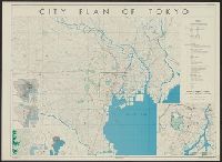
City plan of Tōkyō
City plan of Yokohama

Tokyo city plan

Plan of Hong Kong City of Victoria . . .
Tokyo city plan : Marunouchi
A 399. View of Kōbe
Helix City Project, Tokyo, Japan (Plan)
City of Kobe 192A
Evening Crescent Moon at Kōbe (Kōbe no Yoizuki)
Evening Crescent Moon at Kōbe (Kōbe no Yoizuki)

Plan of Yokohama

Town plan of Wakayama

Reconstruction plan of Yokohama
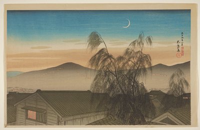
Evening Moon over Kōbe

Plan of house and garden
A 391. Bund at Kōbe

Plan Of Takayama's School Of Dental Surgery
City of life and death

Town plan of Otomari : Japan: Karafuto
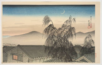
Crescent Moon Over Kobe (Kōbe no Yoizuki)
Floating City project, Kasumigaura, Japan (Plan)
![Kōbe [cartographic material] : municipal water supply, distribution](https://stacks.stanford.edu/image/iiif/yk027jw4267%2Fyk027jw4267_00_0001/full/!200,200/0/default.jpg)
Kōbe [cartographic material] : municipal water supply, distribution

Town plan of Toyohara : Japan: Karafuto

Japan. (inset) Plan of Yeddo Bay
Kōbe [cartographic material] : municipal water supply, distribution

Southwest Japan (Kyūshū, Shikoku, and southwest Honshū), telecommunications

Southwest Japan (Kyūshū, Shikoku, and southwest Honshū), cotton spinning, silk and rayon production

Southwest Japan (Kyūshū, Shikoku, and southwest Honshū), lumber and allied industries [cartographi...

Southwest Japan (Kyūshū, Shikoku, and southwest Honshū), non-metallic mineral production

Southwest Japan (Kyūshū, Shikoku, and southwest Honshū), railroads and railroad facilities [cartog...

Southwest Japan (Kyūshū, Shikoku, and southwest Honshū) water works and springs [cartographic mate...
Japan--USSR : northern territories / Central Intelligence Agency

Proposed plan of Ujigawa denki kabushiki kwai-sha : From Nango, Ishiyama-Mura, Shiga Prefecture, t...

Southwest Japan (Kyūshū, Shikoku, and southwest Honshū) non-ferrous metals, mines and processing p...

Isahaya, Japan, Nagasaki-ken, Kyushū.
![Japan [cartographic material] : ports of greatest shipping activity](https://stacks.stanford.edu/image/iiif/yg817zs3009%2Fyg817zs3009_00_0001/full/!200,200/0/default.jpg)
Japan [cartographic material] : ports of greatest shipping activity
![Kure [cartographic material] : plan of port and naval establishments](https://stacks.stanford.edu/image/iiif/rk636yd7844%2Frk636yd7844_0001/full/!200,200/0/default.jpg)
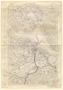
Kure [cartographic material] : plan of port and naval establishments

Hitoyoshi, Japan, Kumamoto Ken, Kyushu
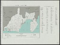
Japan. Shizuoka-ken : administrative divisions, November 1943

Southwest Japan (Kyushu, Shikoku, and Southwest Honshu) : Cities and towns (Shi) : size and functi...
![Tōkyō, Ōmori-ku, guide to postal districts [cartographic material] = 大森區詳細圖](https://collections.library.yale.edu/iiif/2/15511728/full/!200,200/0/default.jpg)
Tōkyō, Ōmori-ku, guide to postal districts [cartographic material] = 大森區詳細圖

Southwest Japan (Kyushu, Shikoku, and Southwest Honshu) : surpluses and deficits of food resources

Hachinohe, Aomori Prefecture, Honshu, Japan
![Japan, radiotelephone and radiotelegraph stations [cartographic material] : 1941](https://stacks.stanford.edu/image/iiif/pp234mp0165%2Fpp234mp0165_00_0001/full/!200,200/0/default.jpg)
Japan, radiotelephone and radiotelegraph stations [cartographic material] : 1941
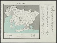
Hyōgo-ken

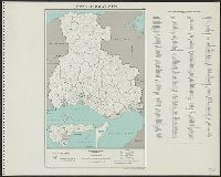
Japan. Gifu-ken : administrative divisions, November 1943

Kajiki, Japan, Kagoshima-ken, Kyushu
Japan. Aichi-ken : administrative divisions, November 1943
Last Updated: 2020-04-17
Uploaded: 2021-09-21