Ikaiei fukin Tōshū-fu kō[?] gekisen no zu
Ikaiei fukin Tōshū-fu kō[?] gekisen no zu
Ikaiei fukin Tōshū-fu kō[?] gekisen no zu
Triptych: Ikaiei fukin Tōshū-fu kō[?] gekisen no zu
Jūmanbun no ichi Ranryō Boruneo : Barikkupapan fukin: XXIX/62 (16)
Jūmanbun no ichi Ranryō Boruneo : Barikkupapan fukin / Rikuchi Sokuryōbu
Chūko fukin dai jūni shidan no sentō san-gatsu jūroku-nichi
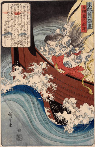
The Legend of Azuma Wood (Azuma no Mori no Koji), series Ancient Sites of the Eastern Capital (東都旧跡尽)

Uke-ni-iru fu no ji Tsukushi (Object)

The Japanese Forces March Onward near the Yalu River (Ōryokko fukin shiingun no zu)

Mt. Fuji, Clearing after a Snowfall in Oshiono (Fuji no yukibare (Oshiono fukin))

Paris, France (Furansu Parisu no fu), from the series "Collection of Scenic Places in Foreign Lands (Bankoku meisho zukushi no uchi)"

Konrei ironaoshi no dzu

The Battle of Kangwachai Near Haicheng: The Tatsumi Brigade Achieves a Brilliant Battle Result (Kaijō fukin Kōgasai no eki, Tatsumi ryodan no senkō)

No 10 Retsu-fu wakari oshigatte ishi to nari Sayo-hime (Object); Honcho Nenreki Zue (Series)

Konjaku miken seibutsu mōko no shinzu

Shinpan ukie shiba sinmeigū no zu

Shinpan ukie shiba shinmeigū no zu

The Russo-Japanese War Illustrated News No. 6: A Severe Battle at Pingyang (Nichi-Ro sensō gahō sono roku: Keijō fukin gekisen)

Suiraitei suirai hassha no zu

Sanmai-zuzuki (Object); Konrei iro-naoshi no zu (Object)

Tōkyō meishō Takanawa no shinkei
Gama Sennin, from the series Ibaraki no keshin
Kokeshi to Oiran, Toys No. 1
Nanpōken jikyoku shigen seizu

Carte des terres aux environs du Japon ou du nord-est de l'Asie et du nord-ouest de l'Amérique ext...
[Ajia tōbu meisaizu] / Okamura Shōbē cho
Dai ichi-gun shotai no ichi

Carte des terres aux environs du Japon ou du nord-est de l'Asie et du nord-ouest de l'Amérique ext...

Mandchourie et Coree de Kharbine a Seoul de Port-Arthur a Vladivostok Traduction de la Carte d'Eta...

亜細亜東部略図
Stanford's map of eastern China, Japan and Korea : the seat of war in 1894

日本府縣管内地圖 佐賀縣

The Islands of Japan, by James Wyld,..
Craigie's map of South Australia showing towns, roads & railways / compiled, drawn & published by Kenneth Craigie & Co

Nagasaki

Map of Chosen (Korea)

飛騨国図

A New Map of Asia from the latest Observations Most Humbly Inscrib'd to the Right Honbl. George Ea...
Nara, Yamada, Koyasan, and environs

The Japanese empire : with central and southern Manchukuo (Manchuria)

日本交通分縣地圖 第二十九 佐賀縣

「月次絵」 「四月」
「白沢之図」

The Islands of Japan, by James Wyld,..
「(市川市蔵」 「死絵)」
Korea / prepared ... by the Army Map Service, U.S. Army

岐阜県管内地図 全
最終更新日: 2020-06-05
登録日: 2021-07-22