


![[東宮御所]扉上部詳細図](https://archive.library.metro.tokyo.lg.jp/da/download/?id=0000000016-00067239&size=listThumb&type=image&file=KI127-002-069.jpg)
![[東宮御所]扉上部詳細図](https://archive.library.metro.tokyo.lg.jp/da/download/?id=0000000016-00067238&size=listThumb&type=image&file=KI127-002-068.jpg)


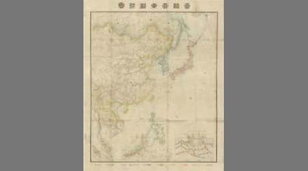
![大亜細亜 [その1]](https://da.lib.kobe-u.ac.jp/files/thumbnail/20000/0100383560/0100383560.jpg)

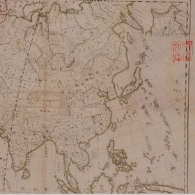
![大亜細亜 [その2]](https://da.lib.kobe-u.ac.jp/files/thumbnail/20000/0100383561/0100383561.jpg)
![大亜細亜 [その6]](https://da.lib.kobe-u.ac.jp/files/thumbnail/20000/0100383565/0100383565.jpg)
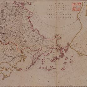
![大亜細亜 [その5]](https://da.lib.kobe-u.ac.jp/files/thumbnail/20000/0100383564/0100383564.jpg)
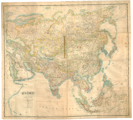
![大亜細亜 [その7]](https://da.lib.kobe-u.ac.jp/files/thumbnail/20000/0100383566/0100383566.jpg)

Nagasaki

滿洲歴史地理. : 第壹巻附図 : 隋代及唐初満洲図(西暦五八九年-六六八年)
![安房国[東海道図]](https://rmda.kulib.kyoto-u.ac.jp/iiif/RB00020023/RB00020023_00001_0.ptif/full/200,/0/default.jpg)
安房国[東海道図]

佐賀縣管内全圖
Stanford's map of eastern China, Japan and Korea : the seat of war in 1894

Japan : to illustrate the paper by Ellen Churchill Semple.

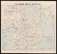
Nara, Yamada, Koyasan, & environs

Carte Des Indes et de la Chine Dressee sur plusieurs Rectifees par quelques Observations Par Guill...

大日本帝國西南部地形圖
Kōgun senka kakudai ikkenzu : (fu) fukin chiten no koji gaisetsu
Korea / prepared ... by the Army Map Service, U.S. Army
Dai ni-gun no heitan : Meiji sanjūnana-nen hachi-gatsu jūichi nichi

佐賀県管内図
Nara, Yamada, Koyasan, & environs

Strategical map of part of Korea and Manchuria / prepared by the Second Division, General Staff (Military In...

Map of Chosen (Korea)

The Japanese empire : with central and southern Manchukuo (Manchuria)
Dai ichi-gun shotai no ichi
![[Map of Korea] Karta Korei, nyne Yaponskago General-Gubernatorstva Tsiosen, s Yaponskimi Geografic...](https://stacks.stanford.edu/image/iiif/wm529gv6020%2F36877/full/!200,200/0/default.jpg)
[Map of Korea] Karta Korei, nyne Yaponskago General-Gubernatorstva Tsiosen, s Yaponskimi Geografic...

Mandchourie et Coree de Kharbine a Seoul de Port-Arthur a Vladivostok Traduction de la Carte d'Eta...
A new & correct chart of the Indian Sea from Cabo Bonea Esperanca to Japan according to Mr. Edward Wrights projection vulgarly called Mercators chart

Greece in the fifth century B.C

名護屋古城之図
Last Updated: 2020-04-16
Uploaded: 2021-07-27