
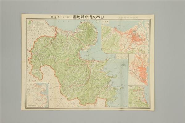
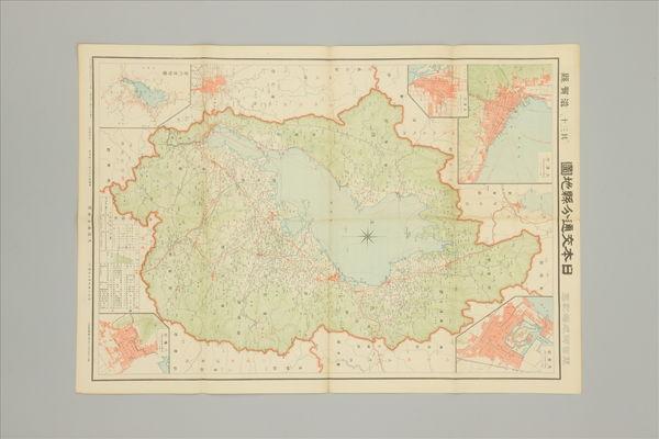
日本交通分縣地圖 第二十九 佐賀縣
Saga Prefectual Library
Saga Prefectural Library Database

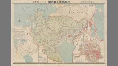
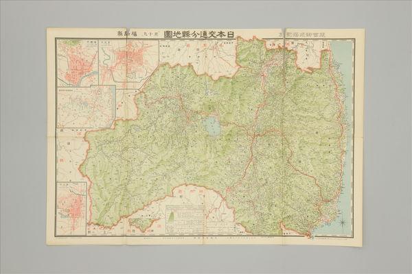
「日本交通分縣地圖 其17」 兵庫縣
Kochi Prefectural Library
OTEPIA Kochi Library collection search

日本府縣管内地圖 佐賀縣
Saga Prefectual Library
Saga Prefectural Library Database

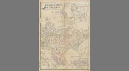
日本新分縣地図 佐賀縣
Saga Prefectual Library
Saga Prefectural Library Database

佐賀縣管内全圖
Saga Prefectual Library
IIIF Discovery in Japan
佐賀縣管内全圖
Saga Prefectual Library
Saga Prefectural Library Database

佐賀縣管内全圖
Saga Prefectual Library
IIIF Discovery in Japan

佐賀縣管内之圖
Saga Prefectual Library
IIIF Discovery in Japan
佐賀近傍之圖 第二号
Saga Prefectual Library
Saga Prefectural Library Database

佐賀近傍之圖 第二号
Saga Prefectual Library
IIIF Discovery in Japan
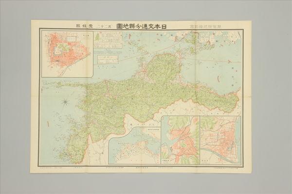
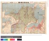
日本交通分県地図 「其二十」 大分県
Sekigahara Town History and Folklore Museum
Sekigahara Collection Database
日本交通分県地図 「其三十」 滋賀県
Sekigahara Town History and Folklore Museum
Sekigahara Collection Database

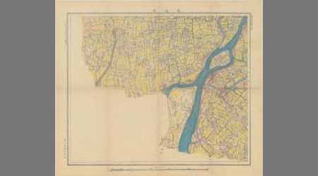
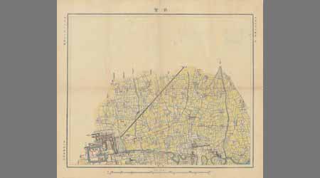
佐賀市街明細地圖
Saga Prefectual Library
IIIF Discovery in Japan
日本交通分県地図 「其十九」 福島県
Sekigahara Town History and Folklore Museum
Sekigahara Collection Database
日本交通分県地図 「其二十二」 愛媛県
Sekigahara Town History and Folklore Museum
Sekigahara Collection Database

九州交通地図
Fukuoka City Museum
Fukuoka City Museum Collection Database

大日本交通明細地圖
Kochi Prefectural Library
OTEPIA Kochi Library collection search
佐賀近傍之圖 第一号
Saga Prefectual Library
Saga Prefectural Library Database

佐賀近傍之圖 第一号
Saga Prefectual Library
IIIF Discovery in Japan

「日本交通分縣地図新潟縣 其四十一」 大阪毎日新聞第17029号付録
Kochi Prefectural Library
OTEPIA Kochi Library collection search

世界産業交通地圖
Yoshida-South Library, Kyoto University
IIIF Discovery in Japan
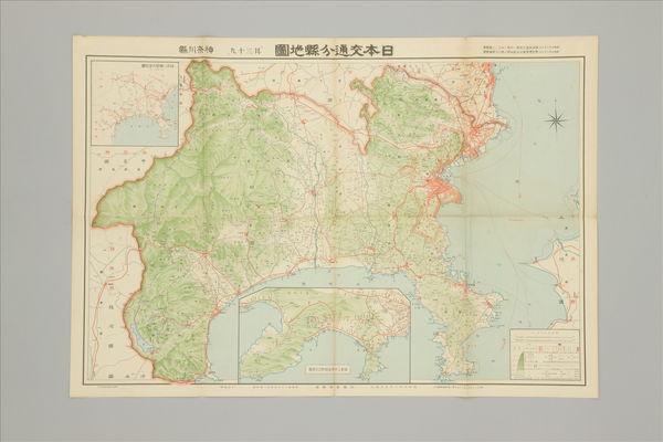
日本交通分県地図 「其三十九」 神奈川県
Sekigahara Town History and Folklore Museum
Sekigahara Collection Database
本縣第二十三號
Graduate School for Law and Politics, the University of Tokyo
UTokyo Academic Archives Portal
日本交通分県地図其二十八 福岡県
Fukuoka Prefectural Library
ADEAC: A System of Digitalization and Exhibition for Archive Collections

Magnae Tartariae Magni Mogolis Imperii Iaponiae et Chinae Nova Descriptio
Stanford University Libraries
Stanford Libraries SearchWorks
![Japan, Yamaguchi-ken [cartographic material]](https://stacks.stanford.edu/image/iiif/zc849tw9296%2Fzc849tw9296_00_0001/full/!200,200/0/default.jpg)
Japan, Yamaguchi-ken [cartographic material]
Stanford University Libraries
Stanford Libraries SearchWorks

A New and Accurate Map of the Colony of Massachusets Bay, In North America from a Late Survey
Stanford University Libraries
Stanford Libraries SearchWorks

佐賀県管内図
Saga Prefectual Library
IIIF Discovery in Japan
佐賀縣管内全圖
Saga Prefectual Library
IIIF Discovery in Japan

Carte du théâtre de la guerre Russo-Japonaise
Bibliothèque nationale de France
Europeana API
![Tokyo and vicinity, showing bombed-out areas [cartographic material]](https://stacks.stanford.edu/image/iiif/jx217xm7539%2Fjx217xm7539_00_0001/full/!200,200/0/default.jpg)
Tokyo and vicinity, showing bombed-out areas [cartographic material]
Stanford University Libraries
Stanford Libraries SearchWorks

The Empire of China and Island of Japan, Agreeable to Modern History
Stanford University Libraries
Stanford Libraries SearchWorks

Maris Pacifici quod vulgo Mar del Zud
Stanford University Libraries
Stanford Libraries SearchWorks

Asiae Nova Delineatio . .
Stanford University Libraries
Stanford Libraries SearchWorks

Mandchourie et Coree de Kharbine a Seoul de Port-Arthur a Vladivostok Traduction de la Carte d'Eta...
Stanford University Libraries
Stanford Libraries SearchWorks

China, Contains 15 Subject Provinces, including the 2 Islands of Hainan Formosa and the Tributary ...
Stanford University Libraries
Stanford Libraries SearchWorks

L'Empire de la Chine d'après l'Atlas Chinois avec les Isles du Japon . .
Stanford University Libraries
Stanford Libraries SearchWorks
![Map of Manchuria, Corea & Japan [cartographic material]](https://collections.library.yale.edu/iiif/2/15828540/full/!200,200/0/default.jpg)
Map of Manchuria, Corea & Japan [cartographic material]
Yale University Library
Yale University Library Digital Collections

Ost-Indien
Stanford University Libraries
Stanford Libraries SearchWorks
Last Updated: 2020-04-16
Uploaded: 2021-07-27