

The Islands of Japan, by James Wyld,..
Bibliothèque nationale de France
Europeana API
The Islands of Japan with Corea, Manchooria and the russian territory on the Amoor
National Library of Poland
Europeana API

Figures and descriptions of the fishes of Japan : including Riukiu Islands, Bonin Islands, Formosa...
スミソニアン図書館
Europeana API

China and Japan. (with) Islands of Japan. By Keith Johnston, F.R.S.E. Keith Johnston's General Atl...
Stanford University Libraries
Stanford Libraries SearchWorks
Map of the Japan Islands : copied from von Siebold's with slight additions & corrections, by the U.S. Japan Expedition and other authorities / Compiled by order of Commodore M.C. Perry, U.S.N. by Lieuts. W.L. Maury and Silas Bent ; James Ackerman, lith. 379 Broady NY
National Library of Australia
Trove: National Library of Australia

The lantern-fishes of Japan / by Charles H. Gilbert
Harold B. Lee Library
Europeana API

Japan Series: Islands
Museum of New Zealand Te Papa Tongarewa
DigitalNZ New Zealand API

Japan Series: Islands
Museum of New Zealand Te Papa Tongarewa
DigitalNZ New Zealand API

REPRESENTATION OF THE EMPRESS OF JAPAN BY A MALE ACTOR
Auckland Libraries
DigitalNZ New Zealand API

A hand-list of the birds of Japan, by M. Ogawa
University of California Libraries
Europeana API

Visit by Cecilia Malmström, Member of the EC, to Japan
Audiovisual Library of the European Commission
Europeana API

Visit by Cecilia Malmström, Member of the EC, to Japan
Audiovisual Library of the European Commission
Europeana API

Visit by Cecilia Malmström, Member of the EC, to Japan
Audiovisual Library of the European Commission
Europeana API

Visit by Cecilia Malmström, Member of the EC, to Japan
Audiovisual Library of the European Commission
Europeana API

Visit by Cecilia Malmström, Member of the EC, to Japan
Audiovisual Library of the European Commission
Europeana API

Visit by Cecilia Malmström, Member of the EC, to Japan
Audiovisual Library of the European Commission
Europeana API

Visit by Cecilia Malmström, Member of the EC, to Japan
Audiovisual Library of the European Commission
Europeana API

Visit by Cecilia Malmström, Member of the EC, to Japan
Audiovisual Library of the European Commission
Europeana API

Visit by Cecilia Malmström, Member of the EC, to Japan
Audiovisual Library of the European Commission
Europeana API

Visit by Cecilia Malmström, Member of the EC, to Japan
Audiovisual Library of the European Commission
Europeana API

Visit by Cecilia Malmström, Member of the EC, to Japan
Audiovisual Library of the European Commission
Europeana API

Visit by Cecilia Malmström, Member of the EC, to Japan
Audiovisual Library of the European Commission
Europeana API

Visit by Cecilia Malmström, Member of the EC, to Japan
Audiovisual Library of the European Commission
Europeana API

Visit by Cecilia Malmström, Member of the EC, to Japan
Audiovisual Library of the European Commission
Europeana API
The Islands of Japan, by James Wyld,..
Bibliothèque nationale de France
Europeana API

[Croquis indiquant les positions des Russes et des Japonais (23 février-10 mars 1905) pendant la b...
Bibliothèque nationale de France
Europeana API

Partie Septentrionale De L'Ocean Pacifique ou L'on Marque Les Decouvertes Et Les Routes De Mrs. De...
Stanford University Libraries
Stanford Libraries SearchWorks
![[Hokkaidō Jissoku Kirizu]](https://stacks.stanford.edu/image/iiif/mr402ns1367%2Fmr402ns1367_00_0001/full/!200,200/0/default.jpg)
[Hokkaidō Jissoku Kirizu]
Stanford University Libraries
Stanford Libraries SearchWorks

Partie Septentrionale De L'Ocean Pacifique ou L'on Marque Les Decouvertes Et Les Routes De Mrs. De...
Stanford University Libraries
Stanford Libraries SearchWorks
![America Bay [cartographic material]](https://stacks.stanford.edu/image/iiif/nj035cf2832%2Fnj035cf2832_00_0001/full/!200,200/0/default.jpg)
America Bay [cartographic material]
Stanford University Libraries
Stanford Libraries SearchWorks

Kaetsunousanshuugunwakeryakuezu
Imizu City Shinminato Museum
ADEAC: A System of Digitalization and Exhibition for Archive Collections

T'land van Jeso
Bibliothèque nationale de France
Europeana API

佐賀県管内図
Saga Prefectual Library
IIIF Discovery in Japan
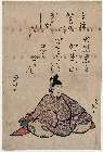
「大伴黒主」
Museum of Fine Arts, Boston
ARC Ukiyo-e Portal Database
Kūchū shashin yōzu Sanman Gosen bun no ichi Bisumaruku Guntō (sheet 1)
National Library of Australia
Trove: National Library of Australia
![[Carte du théâtre de la guerre en extrême orient] / [dressée par V. Adrianov]](https://api.europeana.eu/api/v2/thumbnail-by-url.json?uri=http%3A%2F%2Fgallica.bnf.fr%2Fark%3A%2F12148%2Fbtv1b53060752p.thumbnail.jpg&type=IMAGE)
[Carte du théâtre de la guerre en extrême orient] / [dressée par V. Adrianov]
Bibliothèque nationale de France
Europeana API

Map of Chosen (Korea)
Yale University Library
Yale University Library Digital Collections

Northwestern America Showing The Territory Ceded By Russia To The United States Compiled For The D...
Stanford University Libraries
Stanford Libraries SearchWorks

Japan, Hokushu _ West Coast. Iwanai Byochi and Approaches
Stanford University Libraries
Stanford Libraries SearchWorks
Last Updated:
Uploaded: 2021-07-27