


「駿州富士郡」「駿東郡三牧大絵図」
Kasei Biruma Gojūmanbun ichi zu (7 he 501)
分間江戸大絵図
「三番叟」
平等院壁扉画(模本)
片田景図(模本)

1963カレンダー入甲府市街図

日本之図
A new chart of the Indian and Pacific Oceans between the Cape of Good Hope, New Holland and Japan : comprehending New Zealand, New Caledonia, New Britain, New Ireland, New Guinea &c., also the New Caroline, Ladrone and Philippine Islands : with the tracks of the English, French, Spanish and Dutch discoverers

甲斐国全図
「三代目松本幸四郎」
Manshūkoku chizu / Minami Manshū Tetsudō Kabushiki Kaisha chosaku ken hakkō
Chūō Ajia no zu. Rokoku

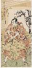
「山崎屋娘おてる 岩井半四郎」
□□
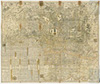
![[下図]「射水郡分間絵図」文政六年九月](https://adeac.jp/items/imizu-shinminato-mus/catalog/mp101660-15100/3-1-BII2v2.jpg)
[下図]「射水郡分間絵図」文政六年九月
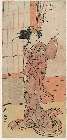
「二代小佐川常世(おさがわつねよ)」
Laurie and Whittle's new chart of the Indian and Pacific Oceans between the Cape of Good Hope, New Holland, and Japan, comprehending New Zealand, New Caledonia, New Britain, New Ireland, New Guinea,&c., Louisiade and New Georgia; also the Pelew, New Caroline, Ladrone, and Philippine Islands; &c. with the most remarkable tracks of the English, Spanish, French and Dutch navigators: and chiefly the track of the Walpole, Eastindiaman, Captn. Thos. Butler, 1794 from the Cape of Good Hope to Van Diemen's Land and, from thence to China, and the track of the Royal Admiral Captn. Henr. Bond in 1792 and 93, from the Cape to Port Jackson and China

福吉村廿五番字五本黒木全圖

「箱根七温泉図」
「九月(右)」

「〔箱根絵図〕」
Jūmanbun no ichi Ranryō Boruneo : Barikkupapan fukin: XXIX/62 (16)
登録日: 2026-02-25