


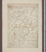


![[箱根温泉図]](https://da.dl.itc.u-tokyo.ac.jp/portal/sites/default/files/styles/large/public/images/assets/ishimoto/b576835f-9f68-4c92-b182-6bf971c3b289_1.jpg?itok=HwZE6oer)


.jpg)
.jpg)
.jpg)


「〔西京廿七番観世音略図〕」

「下総銚子之図」

「西国三十三所順拝地図」

「安芸厳島神社之図」
A new chart of the Indian and Pacific Oceans between the Cape of Good Hope, New Holland and Japan : comprehending New Zealand, New Caledonia, New Britain, New Ireland, New Guinea &c., also the New Caroline, Ladrone and Philippine Islands : with the tracks of the English, French, Spanish and Dutch discoverers

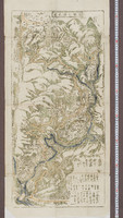
「〔箱根絵図〕」
![「[桃太郎]」 「〔疱瘡に関する絵〕」](https://archive.library.metro.tokyo.lg.jp/da/download/?id=0000000003-00224601&size=thumb&type=image&file=/浮世絵/778-C017.jpg)
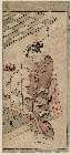
「[桃太郎]」 「〔疱瘡に関する絵〕」

「上州草津温泉之図」

「羽州庄内田川郡湯温泉村絵図」

「豊前国羅漢寺絵図」

「増補両面江戸図鑑」「分間江戸図」

山梨県管内図

「〔地図〕」

「秩父二十八番石竜山橋立寺奥院岩窟絵図」

「武州金沢擲筆山地蔵院能見堂八景之画図」

「上州草津温泉之全図」

「上州草津温泉之図」

「〔御用屋敷地図〕」

「〔鎌倉図〕」

「相州藤沢山遊行寺境内諸堂社略絵図」

Laurie and Whittle's New Chart of the Indian and Pacific Oceans Between the Cape of Good Hope, New...
「九月(右)」

「出羽国置賜郡米沢小野川温泉図」
Pas-caert van't Oostelyckste deel van Oost Indien : met alle de Eylanden daer onder gelegen, van Cabo Comorin tot aen Japan / by Hendrick Doncker Boekverkooper en Graadbooghmaacker Inde Nieuwbrughsteegh
Last Updated: 2019-07-07
Uploaded: 2023-04-03