![[Untitled Sea Chart of Australia, Indian Ocean, China, Japan, SE Asia, &c] (First Printed Map to S...](https://stacks.stanford.edu/image/iiif/cv359wv2441%2F22989/full/!200,200/0/default.jpg)
[Untitled Sea Chart of Australia, Indian Ocean, China, Japan, SE Asia, &c] (First Printed Map to S...
- People
- Time
- Owner Organization
![[Russian Map of Northeastern Asia, Japan, Korea, China, Alaska, etc.] ( Summary map of hydrographi...](https://stacks.stanford.edu/image/iiif/pj697kr2558%2F35405/full/!200,200/0/default.jpg)
[Russian Map of Northeastern Asia, Japan, Korea, China, Alaska, etc.] ( Summary map of hydrographi...

(Covers to) Rand McNally map of Eastern Asia and Western Pacific Ocean Mercator projection. Copyri...

Rand McNally map of Eastern Asia and Western Pacific Ocean. (Mercator projection). Copyright by Ra...

Rand McNally map of Eastern Asia and Western Pacific Ocean. Mercator projection. Copyright by Rand...

South China Sea. South East Asia - Selected Areas. Pergamon World Atlas. Pergamon Press, Ltd. & P....
Japanese Expansion in Asia, 1895-1941 -- Asia, China, U.S.S.R., Mongolia, Russia, India, Burma, Malaya, Sumatra, Dutch East Indies, Borneo, Thailand, French Indochina, Philippines, New Guinea, Australia, Macao, Korea, Japan, Celebes Map / Maps.com(CR)
.jpg)
First Echelon and AIF convoy in the Indian Ocean, January 1940. The ships are: Nearest line (from left), Otr...
Picture map of China. Designed by Frank Randolph Southard. Printed in United States of America. (C...

Picture map of China. Designed by Frank Randolph Southard. Printed in United States of America. (C...

(Covers to) Picture map of China. Designed by Frank Randolph Southard. Printed in United States of...

A new & correct chart of the Indian sea from Cabo Bonea Esperanca to Japan : according to Mr Edwar...
A new chart of the Pacific Ocean : exhibiting the western coast of America, from Cape Horn to Beerings Strait, the eastern shores of Asia including Japan, China and Australia and all the numerous islands and known dangers situated in Polynesia and Australasia / correctly drawn and regulated according to the most approved and modern surveys and astronomical observations by J.W. Norie
Laurie and Whittle's new chart of the Indian and Pacific Oceans between the Cape of Good Hope, New Holland, and Japan, comprehending New Zealand, New Caledonia, New Britain, New Ireland, New Guinea,&c., Louisiade and New Georgia; also the Pelew, New Caroline, Ladrone, and Philippine Islands; &c. with the most remarkable tracks of the English, Spanish, French and Dutch navigators: and chiefly the track of the Walpole, Eastindiaman, Captn. Thos. Butler, 1794 from the Cape of Good Hope to Van Diemen's Land and, from thence to China, and the track of the Royal Admiral Captn. Henr. Bond in 1792 and 93, from the Cape to Port Jackson and China
Laurie and Whittle's new chart of the Indian and Pacific Oceans between the Cape of Good Hope, New Holland and Japan : comprehending New Zealand, New Caledonia, New Britain, New Ireland, New Guinea &c., Louisiade and New Georgia; also The Pelew, New Caroline, Ladrone and Philippine Islands &c. with the most remarkable tracks of the English, Spanish, French and Dutch navigators and chiefly the track of the Walpole, EastIndiaman, Captn. Thos. Butler, 1794 from the Cape of Good Hope to Van Diemen's Land and from thence to China, and the track of the Royal Admiral Captn. Henr. Bond in 1792 and 93 from the Cape to Port Jackson and China
Itsuku-shima dzu-ye

Nouvelle Carte de la Mer Mediterranee Juscques au Cap S. Vincent et Cap Cantin
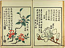
True Depictions of Bird and Flower Pictures : [volume 2]
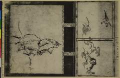
Random Sketches by Hokusai, Volume 6
Encyclopedia of Western Art : [volume 4]
A Diary of Travel from Edo to Nagasaki : [volume 5]

Part 4, Volume 9 of Picture book of the exploits of Toyotomi Hideyoshi (Ehon Toyotomi kunkōki yonhen kyū)
A Fashionable Representation of the Immortals of Poetry: Picture Book of Waka-no-ura : [volume 3]
Picture Album of the Floating World : [volume 3]
Suiseki Picture Album
Chats on Novelties of Foreign Lands : [volume 4]
Picture Book: Ogura Hill : [volume 1]

Shinnoshichiken

Sumō
meisugahu

L'Asie ou sont exactement decrites toutes les Costes de la Mer, suivant les dernieres navigations,...
Diary of Yokohama
Illustrated book : [volume 3 of three?]
Seiougyuu
Picture Book of the Eternal Pines : [volume 3]
True Depictions of Bird and Flower Pictures : [volume 3]
Picture Book: Thousand-Year Mountain? : [final volume]
A Diary of Travel from Edo to Nagasaki : [volume 4]

Asia Divisa nelle sue Parti secondo lo stato presente
Last Updated: 2020-04-17
Uploaded: 2021-09-21