

Military Map of South-Eastern Virginia

Geologic map of the eastern part of Hakone Volcano
Map showing Green Islands, to the north of Biika. Several of the Japanese bases marked on the map 1 have sin...
Map of Tokyo
![[Railroads in China, Manchuria, Korea, Japan and the eastern U.S.S.R.] [cartographic material]](https://stacks.stanford.edu/image/iiif/pf710vm7134%2Fpf710vm7134_00_0001/full/!200,200/0/default.jpg)
[Railroads in China, Manchuria, Korea, Japan and the eastern U.S.S.R.] [cartographic material]
Court Exh. No. 3157C: Map taken from Exhibit No. 2713, being maps of eastern part of U.S.S.R. and adjacent countries
Court Exh. No. 3157: Map taken from Exhibit No. 2713, being maps of eastern part of U.S.S.R. and adjacent countries
Court Exh. No. 3157: Map taken from Exhibit No. 2713, being maps of eastern part of U.S.S.R. and adjacent countries
Court Exh. No. 3157B: Map taken from Exhibit No. 2713, being maps of eastern part of U.S.S.R. and adjacent countries
Court Exh. No. 3157D: Map taken from Exhibit No. 2713, being maps of eastern part of U.S.S.R. and adjacent countries
Court Exh. No. 3157E: Map taken from Exhibit No. 2713, being maps of eastern part of U.S.S.R. and adjacent countries
Court Exh. No. 3157A: Map taken from Exhibit No. 2713, being maps of eastern part of U.S.S.R. and adjacent countries
![[Map of East Asia]](https://stacks.stanford.edu/image/iiif/kg150vx7689%2F41423/full/!200,200/0/default.jpg)
[Map of East Asia]

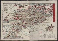
Map of Northern Japan. Map of Southern Japan
Keifu Testudō senro ryakuzu = Map of the Seoul-Pusan Railway ; Fu Tōyō Tetsudō senro ryakuzu = Map of the Eastern Railways

Map of Tokio

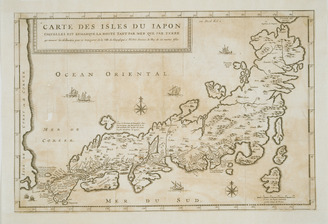
Map of Japan
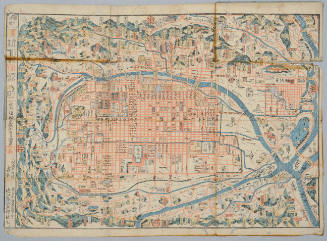
Map of Kyoto
[Map of Kyoto]
![[Map of Kyoto]](https://collections.library.yale.edu/iiif/2/15510884/full/!200,200/0/default.jpg)
[Map of Kyoto]

Map of Japan
Map of Niigate
![[Map of China]](https://collections.library.yale.edu/iiif/2/16189150/full/!200,200/0/default.jpg)
[Map of China]

Map of Kyoto
![Yokohama : [base map showing political divisions]](https://stacks.stanford.edu/image/iiif/hg765ms3579%2Fhg765ms3579_00_0001/full/!200,200/0/default.jpg)
Yokohama : [base map showing political divisions]
日本島図
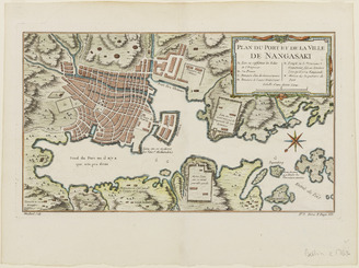
<i>Map of the Port and Town of Nagasaki</i>

Kannon reigen ki Saigoku Pilgrimage No. 9 : Nan'endoo, Nara, Washuu
![[英国文学地図]](https://rmda.kulib.kyoto-u.ac.jp/iiif/RB00023956/RB00023956_00001_0.ptif/full/200,/0/default.jpg)
[英国文学地図]

Kingdoms of the succesors of Alexander C.B.C. 300 : dominions of Ptolemy

Indische Oceaan >> Kaart van de Indische Zee, van de Kaap de Goede Hoop tot Japan

Dominions and Dependencies of Alexander C.B.C. 323

Garten des Tenryuzi-Tempels, Kyoto

Routes from "The Cruise of Her Majesty's Ship “Bacchante,” 1879-1882. Compiled from the private jo...

北海道の観光と交通

La Gran Tartaria divisa nelle sue parti prinicpali . . . conforme le relazioni, che s' hanno da gl...
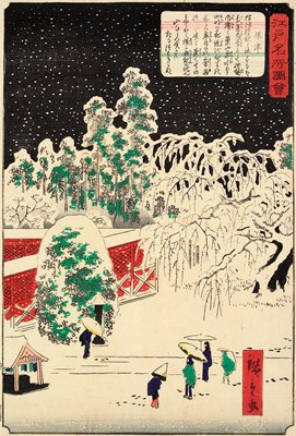
Nezu

Dioscorea opposita Thunb
改正攝津大坂圖
Nepeta glechoma Benth. subsp. grandis
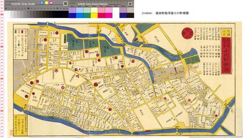
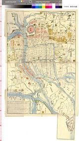
増補改正飯田町駿河臺小川町繪圖
![Suirobu Hi [Kaizu]](https://stacks.stanford.edu/image/iiif/nm634np1065%2Fnm634np1065_0001/full/!200,200/0/default.jpg)
Suirobu Hi [Kaizu]

徳島市街全図

NagasakiPlattegrond van de stad Nagasaki, vervaardigd in Japan in de 18e eeuw
Harry Potter

The occupations (Series)

Eastern Archipelago. Flores and Timor Seas

kachouzu
Last Updated: 2020-04-16
Uploaded: 2021-07-22