Map showing Green Islands, to the north of Biika. Several of the Japanese bases marked on the map 1 have sin...
- Time
- Owner Organization

Map of Eastern U.S.S.R. Missile Bases
Tate Gallery
The Tate Collection

Map - Japan, Trust Territory of the Pacific Islands
Museum of Transport and Technology Auckland
DigitalNZ New Zealand API
Map of North Africa showing the extent of operations undertaken by the Long Range Desert Group during World ...
Alexander Turnbull Library
DigitalNZ New Zealand API
Map showing Pelew Island, immediately north of Dutch New Guinea, and Dili, in Portuguese Timor, between whic...
National Library of New Zealand
DigitalNZ New Zealand API

Coal Resources of the World. Japan. Map No. 14. Plate I. Map Showing the Distribution of Coal in J...
Stanford University Libraries
Stanford Libraries SearchWorks
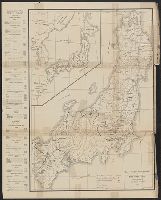
Map of Japan showing areas of jurisdiction of the several armies. Report No. 4g, USSBS Index Section 2
NDL Digital Collections
NDL Digital Collections
Map of the missionary districts of north Tokyo & Kyoto : under the jurisdiction of the Bishop of Tokyo 1895
Yale University Library
Yale University Library Digital Collections

What are the possibilities of attacking the Islands of Japan. Map by Charles Owens, Times Staff Ar...
Stanford University Libraries
Stanford Libraries SearchWorks
Scene showing New Zealand troops loading drums of benzine onto a truck from the water, Green Island, North S...
Alexander Turnbull Library
DigitalNZ New Zealand API
Court Exh. No. 2570: Map showing various sectors or divisions of the city of Hankow, and showing the various routes of entry of the several units and their disposition
NDL Digital Collections
NDL Digital Collections
Court Exh. No. 2570: Map showing various sectors or divisions of the city of Hankow, and showing the various routes of entry of the several units and their disposition
NDL Digital Collections
NDL Digital Collections

An accurate Map of the British Colonies in North Ameria bordering on the River Ohio (First Appeara...
Stanford University Libraries
Stanford Libraries SearchWorks
Map showing the lay-out of the. city of Shanghai, the centre of the present Sino-Japanese ivarfare. Even the...
National Library of New Zealand
DigitalNZ New Zealand API
WAR IN THE EAST This map shows Malaya and the Philippine Islands and the principal scenes of the Japanese of...
National Library of New Zealand
DigitalNZ New Zealand API

A Map of the Icy Sea in which the several Communications with the Land Waters and other new Discov...
Stanford University Libraries
Stanford Libraries SearchWorks

(Composite Map of) Map of the Island of Japan, Kurile &c. with the Adjacent Coasts of the Chinese ...
Stanford University Libraries
Stanford Libraries SearchWorks
Map of Manila Bay, showing Bataan Peninsula, on the west of the bay, where General Mac Arthur's American and...
National Library of New Zealand
DigitalNZ New Zealand API
This map of the Pacific shows the "pincers" strength of the United States from the Aleutian Islands in the n...
National Library of New Zealand
DigitalNZ New Zealand API

A New and Accurate Map of the Colony of Massachusets Bay, In North America from a Late Survey
Stanford University Libraries
Stanford Libraries SearchWorks

A New and Accurate Map of the Colony of Massachusets Bay, In North America from a Late Survey
Stanford University Libraries
Stanford Libraries SearchWorks

A New Map of North America, with the British, French, Spanish, Dutch & Danish Dominions on that gr...
Stanford University Libraries
Stanford Libraries SearchWorks

A cartograph of the major Philippine Islands. "The Riviera of the Orient". Cartograph by Ruth Tayl...
Stanford University Libraries
Stanford Libraries SearchWorks
To the north, the Japanese strongpoint of Pegu has fallen. In the west the Allies have entered the river por...
National Library of New Zealand
DigitalNZ New Zealand API

A Map of the Middle British Colonies In North America First Published By Mr. Lewis Evans of Philad...
Stanford University Libraries
Stanford Libraries SearchWorks
Last Updated:
Uploaded: 2020-12-17