![[Map of East Asia]](https://stacks.stanford.edu/image/iiif/kg150vx7689%2F41423/full/!200,200/0/default.jpg)
[Map of East Asia]
- People
- Time
- Owner Organization

(Pictorial map of Asia)
Stanford University Libraries
Stanford Libraries SearchWorks

9 Map manuscript Atlas of Asia with illustrations
Stanford University Libraries
Stanford Libraries SearchWorks
![[Russian Map of Northeastern Asia, Japan, Korea, China, Alaska, etc.] ( Summary map of hydrographi...](https://stacks.stanford.edu/image/iiif/pj697kr2558%2F35405/full/!200,200/0/default.jpg)
[Russian Map of Northeastern Asia, Japan, Korea, China, Alaska, etc.] ( Summary map of hydrographi...
Stanford University Libraries
Stanford Libraries SearchWorks

Political Map Asia Japan / Maps.com(CR)
National Library of Australia
Trove: National Library of Australia
USGS OFR 98-769: Geographic base map of northeast Asia
Stanford University Libraries
Stanford Libraries SearchWorks
![[Untitled Map of the Ancient World : Europe, Asia and Africa]](https://stacks.stanford.edu/image/iiif/ss295kf6573%2F37437/full/!200,200/0/default.jpg)
[Untitled Map of the Ancient World : Europe, Asia and Africa]
Stanford University Libraries
Stanford Libraries SearchWorks
.jpg)
SOUTH-EAST ASIA AND EAST INDIES ARCHIPELAGO
New Zealand Electronic Text Collection
DigitalNZ New Zealand API

India Extrema XIX Nova Tabula (1st Printed Map of Asia)
Stanford University Libraries
Stanford Libraries SearchWorks
JPRS report. East Asia. Japan
Stanford University Libraries
Stanford Libraries SearchWorks
Map - South East Asia and the Pcific Islands
NDL Digital Collections
NDL Digital Collections
Relief map of Japan and South East Asia from Camouflage Unit, AHQ, World War II
Alexander Turnbull Library
DigitalNZ New Zealand API
The fading productivity of schooling in East Asia
German National Library
Europeana API
Berg encyclopedia of world dress and fashion. East Asia
Stanford University Libraries
Stanford Libraries SearchWorks
![Sea fisheries of eastern Asia [cartographic material]](https://stacks.stanford.edu/image/iiif/mr870gt3467%2Fmr870gt3467_00_0001/full/!200,200/0/default.jpg)
Sea fisheries of eastern Asia [cartographic material]
Stanford University Libraries
Stanford Libraries SearchWorks
Business travel in East Asia. (includes list of East Asian tourist offices)(special advertising section)
Trove: National Library of Australia
Map of Japan
Univerzita Karlova. Mapová sbírka
Europeana API
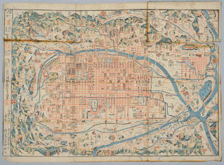
![[Map of Kyoto]](https://collections.library.yale.edu/iiif/2/15510884/full/!200,200/0/default.jpg)
[Map of Kyoto]
Yale University Library
Yale University Library Digital Collections
Map of Kyoto
Honolulu Museum of Art
Honolulu Museum of Art Collection
[Map of Kyoto]
National Library of Australia
Trove: National Library of Australia

Map of Japan
Boston Public Library
DPLA API

Map of Japan
Stanford University Libraries
Stanford Libraries SearchWorks
Map of Niigate
Yale University Library
Yale University Library Digital Collections
![[Map of China]](https://collections.library.yale.edu/iiif/2/16189150/full/!200,200/0/default.jpg)
[Map of China]
Yale University Library
Yale University Library Digital Collections

Map of Kyoto
Philadelphia Museum of Art
Philadelphia Museum of Art collection

Ōmi Kuni-ezu
Stanford University Libraries
Stanford Libraries SearchWorks
![Sekitan no seisan narabi ryūdō ryakuzu [cartographic material]](https://stacks.stanford.edu/image/iiif/dj862yn2265%2Fdj862yn2265_00_0001/full/!200,200/0/default.jpg)
Sekitan no seisan narabi ryūdō ryakuzu [cartographic material]
Stanford University Libraries
Stanford Libraries SearchWorks

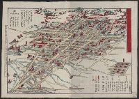
佐賀県管内全図
Saga Prefectual Library
IIIF Discovery in Japan

「清水寺随求堂」
C. V. Starr East Asian Library, University of California, Berkeley
ARC Ukiyo-e Portal Database
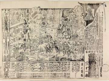
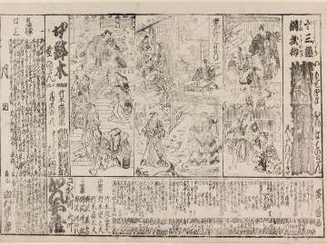
Azumakagamikaidanbanashi、nuretadoshisudanomichiyuki
Museum of Fine Arts, Boston
ARC Banzuke (Playbills) Portal Database
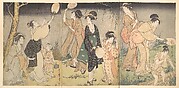
Catching fireflies (Hotaru gari)
Metropolitan Museum of Art
The Metropolitan Museum of Art Open Access CSV

Asiae Nova Descriptio
Stanford University Libraries
Stanford Libraries SearchWorks

Kaikoku zenzu
Yamanashi Prefectural Library
Yamanashi Digital Archive
Imoseyamaonnateikin、onnahachinoki
Museum of Fine Arts, Boston
ARC Banzuke (Playbills) Portal Database

(銅板近江八景) 「ひらのぼせつ」
Art Institute of Chicago
ARC Ukiyo-e Portal Database

Il Regno Della China detto presentamente Catay e Mangin . . . 1682
Stanford University Libraries
Stanford Libraries SearchWorks
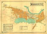
水戸市現勢地図
水戸市立中央図書館
ADEAC: A System of Digitalization and Exhibition for Archive Collections
Last Updated: 2020-04-17
Uploaded: 2021-09-21