
Map of Colorado Territory, Compiled from Government Maps & Actual Surveys. Made In 1861
- People
- Time
- Owner Organization

Map of Colorado Territory, Compiled from Government Maps & Actual Surveys. Made In 1861
Stanford University Libraries
Stanford Libraries SearchWorks

Map of Colorado Territory, Compiled from Government Maps & Actual Surveys. Made In 1861
Stanford University Libraries
Stanford Libraries SearchWorks

Lloyd's Official Map of the State of Tennessee Compiled From Actual Sureys and Official Documents ...
Stanford University Libraries
Stanford Libraries SearchWorks

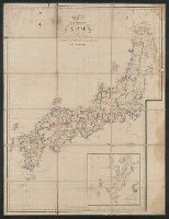
General map of the Government Railways in Japan
General Research Division. The New York Public Library
DPLA API

Japan, Gulf of Ösaka, Hiogo and Ösaka compiled from British and French surveys to 1878
Boston Public Library
DPLA API

map from "The Claims of Japan and Malaysia upon Christendom exhibited in notes of voyages made in ...
British Library
Europeana API

Japan : South coast of Honshu : Gulf of Tokyo or Yedo. Compiled from Japanese Government, and Brit...
Stanford University Libraries
Stanford Libraries SearchWorks

A New and Accurate Map of the Colony of Massachusets Bay, In North America from a Late Survey
Stanford University Libraries
Stanford Libraries SearchWorks

map from "Japan in Transition. A comparative study of the progress, policy, and methods of the Jap...
British Library
Europeana API
A new map of the empires, states, provinces &c of Asia : including also the Turkish & Russian dominions in Europe & New Holland / compiled from the most authentic observations by Robert Wilkinson ; Walsh script. ; W. Palmer sculpt
National Library of Australia
Trove: National Library of Australia
The Suma oriental of Tomé Pires : an account of the East from the Red Sea to Japan, written in Malacca and India in 1512-1515; and, The Book of Francisco Rodrigues, rutter of a voyage in the Red Sea, nautical rules, almanack and maps written and drawn in the East before 1515 (Map in pocket of vol.2: The east, from the Red Sea to Japan, as known to Francisco Rodrigques)
National Library of Australia
Trove: National Library of Australia
Map of Colorado Territory, Compiled from Government Maps & Actual Surveys. Made In 1861
Stanford University Libraries
Stanford Libraries SearchWorks

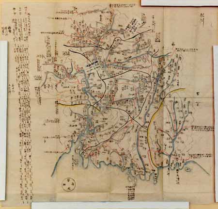
Kaetsunousanshuugunwakeryakuezu
Imizu City Shinminato Museum
ADEAC: A System of Digitalization and Exhibition for Archive Collections
Gōshū shūikizu : Roppyakumanbun no ichi
National Library of Australia
Trove: National Library of Australia
Carte de L'Empire du Japon ..
Yale University Library
Yale University Library Digital Collections

Laurie and Whittle's New Chart of the Indian and Pacific Oceans Between the Cape of Good Hope, New...
Stanford University Libraries
Stanford Libraries SearchWorks

A Chart of the Coast of China From Cambodia to Nanquam with Part of Japan
Stanford University Libraries
Stanford Libraries SearchWorks

伊勢海及三河湾附近沿岸 : 海軍海図日本総部図付海図目録
Iwase Bunko Libray
ADEAC: A System of Digitalization and Exhibition for Archive Collections
Picture Book: Chrysanthemum : [volumes 2-3]
Metropolitan Museum of Art
The Metropolitan Museum of Art Digital Collection
Tajimanokunizu
Geospatial Information Authority of Japan
FishPix
Map of Colorado Territory, Compiled from Government Maps & Actual Surveys. Made In 1861
Stanford University Libraries
Stanford Libraries SearchWorks

Iles Kouriles, Yeso et Sakhaline
Bibliothèque nationale de France
Europeana API
Last Updated: 2020-04-17
Uploaded: 2021-09-21